Jigsaw Puzzle > Animals > Mammals > Muridae > Water Mouse
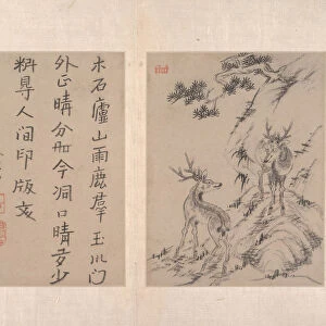
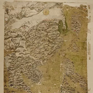
Jigsaw Puzzle : Map of the Grand Canal from Beijing to the Yangzi River, late 18th or early 19th century


![]()
Jigsaw Puzzles from Heritage Images
Map of the Grand Canal from Beijing to the Yangzi River, late 18th or early 19th century
Map of the Grand Canal from Beijing to the Yangzi River, late 18th or early 19th century. Qing dynasty (1644-1911)
Heritage Images features heritage image collections
Media ID 19847637
© Heritage Art/Heritage Images
Beijing Canal Grand Canal Handscrol Handscroll Ink And Color On Silk Qing Dynasty Quing Dynasty Republic Of China Scroll Settlement Yangzi River
Jigsaw Puzzle (520 Pieces)
Discover the rich history of China with our exquisite Jigsaw Puzzle from Media Storehouse. This intriguing puzzle features a captivating map of the Grand Canal from Beijing to the Yangzi River, dating back to the late 18th or early 19th century during the Qing Dynasty (1644-1911). Explore the intricate details of this Heritage Images reproduction, showcasing the historical waterway that once connected China's most significant cities. Engage in a captivating puzzle experience, bringing history to life piece by piece.
Made in the USA, 520-piece puzzles measure 16" x 20" (40.6 x 50.8 cm). Every puzzle is meticulously printed on glossy photo paper, which has a strong 1.33 mm thickness. Delivered in a black storage cardboard box, these puzzles are both stylish and practical. (Note: puzzles contain small parts and are not suitable for children under 3 years of age.)
Jigsaw Puzzles are an ideal gift for any occasion
Estimated Product Size is 50.8cm x 40.5cm (20" x 15.9")
These are individually made so all sizes are approximate
Artwork printed orientated as per the preview above, with landscape (horizontal) or portrait (vertical) orientation to match the source image.
FEATURES IN THESE COLLECTIONS
> Animals
> Mammals
> Muridae
> Water Mouse
> Arts
> Landscape paintings
> Waterfall and river artworks
> River artworks
> Asia
> China
> China Heritage Sites
> The Grand Canal
> Historic
> Ancient civilizations
> Chinese Dynasties
> Historic
> Chinese dynasties paintings
> Maps and Charts
> Early Maps
> Maps and Charts
> Related Images
EDITORS COMMENTS
This handscroll, titled "Map of the Grand Canal from Beijing to the Yangzi River" offers a glimpse into the intricate water transport system that connected Beijing and the Yangzi River during the late 18th or early 19th century. Created during China's Qing dynasty, this ink and color on silk masterpiece showcases both artistic skill and geographical accuracy. The map, displayed in vibrant colors on delicate fabric, highlights various towns, settlements, and geographical features along the canal route. As we follow its meandering path through bustling cities and serene countryside scenes, we are transported back in time to witness an essential mode of transportation in ancient China. The unknown artist masterfully captures not only the physical landscape but also conveys a sense of cultural heritage. This historical artifact serves as a testament to China's rich history and enduring legacy. Preserved within The Metropolitan Museum of Art's collection, this handscroll invites viewers to explore centuries-old trade routes while marveling at its meticulous details. It is a reminder of how transportation systems can shape societies by connecting distant regions economically and culturally. As we admire this remarkable piece of artistry, let us appreciate the ingenuity behind such an extensive canal network that facilitated trade between major Chinese cities for generations.
MADE IN THE USA
Safe Shipping with 30 Day Money Back Guarantee
FREE PERSONALISATION*
We are proud to offer a range of customisation features including Personalised Captions, Color Filters and Picture Zoom Tools
SECURE PAYMENTS
We happily accept a wide range of payment options so you can pay for the things you need in the way that is most convenient for you
* Options may vary by product and licensing agreement. Zoomed Pictures can be adjusted in the Cart.