Jigsaw Puzzle > Europe > United Kingdom > Scotland > Edinburgh > Edinburgh
Jigsaw Puzzle : Map of the Ancient World, (1902). Creator: Unknown
. Creator: Unknown")
. Creator: Unknown")


![]()
Jigsaw Puzzles From Heritage Images
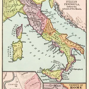
Map of the Ancient World, (1902). Creator: Unknown
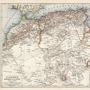
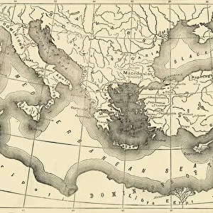
Map of the Ancient World, (1902). Showing Europe, North Africa and the Middle East during the Roman period. From The Century Atlas of the World. [John Walker & Co, Ltd. London, 1902]
Heritage Images features heritage image collections
Media ID 15512308
© The Print Collector / Heritage-Images
Edinburgh Geographical Institute Mediterranean Sea North Africa Roman Empire
Jigsaw Puzzle (520 Pieces)
Discover the mysteries of the ancient world with our exquisite jigsaw puzzle from Media Storehouse. This captivating puzzle showcases a vintage map, originally published in 1902 by John Walker & Co, Ltd. in The Century Atlas of the World. Featuring Europe, North Africa, and the Middle East during the Roman period, this intricate puzzle invites you to explore the rich history and intricate details of this fascinating era. Unravel the puzzle pieces and bring the ancient world to life in your living room. Perfect for history enthusiasts, puzzle lovers, or anyone seeking a challenging and rewarding pastime. Get ready to embark on an educational and enjoyable journey with our Media Storehouse Map of the Ancient World jigsaw puzzle.
Made in the USA, 520-piece puzzles measure 16" x 20" (40.6 x 50.8 cm). Every puzzle is meticulously printed on glossy photo paper, which has a strong 1.33 mm thickness. Delivered in a black storage cardboard box, these puzzles are both stylish and practical. (Note: puzzles contain small parts and are not suitable for children under 3 years of age.)
Jigsaw Puzzles are an ideal gift for any occasion
Estimated Product Size is 50.8cm x 40.5cm (20" x 15.9")
These are individually made so all sizes are approximate
Artwork printed orientated as per the preview above, with landscape (horizontal) or portrait (vertical) orientation to match the source image.
FEATURES IN THESE COLLECTIONS
> Arts
> Artists
> R
> Roman Roman
> Europe
> Italy
> Lazio
> Rome
> Europe
> United Kingdom
> Scotland
> Edinburgh
> Edinburgh
> Europe
> United Kingdom
> Scotland
> Lothian
> Edinburgh
> Historic
> Ancient civilizations
> Roman Empire
> Ancient Rome
> Historic
> Ancient civilizations
> Roman Empire
> Roman art
> Maps and Charts
> Early Maps
> Maps and Charts
> Italy
EDITORS COMMENTS
This print showcases a remarkable "Map of the Ancient World" dating back to 1902. The creator of this masterpiece remains unknown, adding an air of mystery and intrigue to its historical significance. The map vividly depicts Europe, North Africa, and the Middle East during the illustrious Roman period. From "The Century Atlas of the World" published by John Walker & Co in London, this mesmerizing piece offers a glimpse into ancient civilizations that once flourished across these lands. With meticulous attention to detail and vibrant colors, it transports us back in time. As we explore the map's intricate contours, we are transported through centuries-old countries and continents. Italy stands prominently at the heart of this ancient world while North Africa stretches along its southern shores. The Mediterranean Sea acts as a connecting thread between these regions, symbolizing trade routes and cultural exchange during Roman times. Expertly crafted by Edinburgh Geographical Institute, this print serves as both an educational tool for geography enthusiasts and a visual feast for history lovers alike. It encapsulates the grandeur of Rome's empire while highlighting significant locations throughout Europe and the Middle East. Preserved by The Print Collector with utmost care, this photograph captures not only a historical artifact but also our collective fascination with past civilizations. Its timeless appeal transcends commercial use or profit-making intentions; instead, it invites us on an immersive journey through time – reminding us how interconnected our world truly is across centuries gone by.
MADE IN THE USA
Safe Shipping with 30 Day Money Back Guarantee
FREE PERSONALISATION*
We are proud to offer a range of customisation features including Personalised Captions, Color Filters and Picture Zoom Tools
SECURE PAYMENTS
We happily accept a wide range of payment options so you can pay for the things you need in the way that is most convenient for you
* Options may vary by product and licensing agreement. Zoomed Pictures can be adjusted in the Basket.