Jigsaw Puzzle > Asia > Related Images
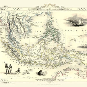
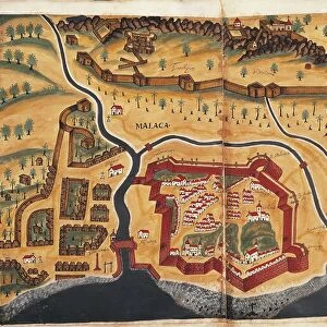
Jigsaw Puzzle : SOUTH ASIA MAP, 1662. Detail of a map of the East Indian archipelago from Johannes Blaeus Atlas Major published, 1662


![]()
Jigsaw Puzzles From Granger
SOUTH ASIA MAP, 1662. Detail of a map of the East Indian archipelago from Johannes Blaeus Atlas Major published, 1662
SOUTH ASIA MAP, 1662. Detail of a map of the East Indian archipelago from Johannes Blaeus " Atlas Major" published, 1662, at Amsterdam
Granger holds millions of images spanning more than 25,000 years of world history, from before the Stone Age to the dawn of the Space Age
Media ID 6617451
1662 Asian Atlas Blaeu Dutch India Johan Portolan Chart Atlas Maior
Jigsaw Puzzle (1014 Pieces)
Step back in time with our exquisite South Asia Map jigsaw puzzle from the Media Storehouse collection. This intriguing puzzle features a detailed map of the East Indian archipelago, taken from the renowned "Atlas Major" published by Johannes Blaeu in 1662. Delve into the rich history of the region as you piece together this stunningly accurate representation of the map, originally created over three centuries ago. A captivating addition to any home or office, this puzzle is perfect for history enthusiasts, geography buffs, or anyone seeking a challenging and rewarding puzzle experience. Immerse yourself in the past as you bring this piece of cartographic history back to life.
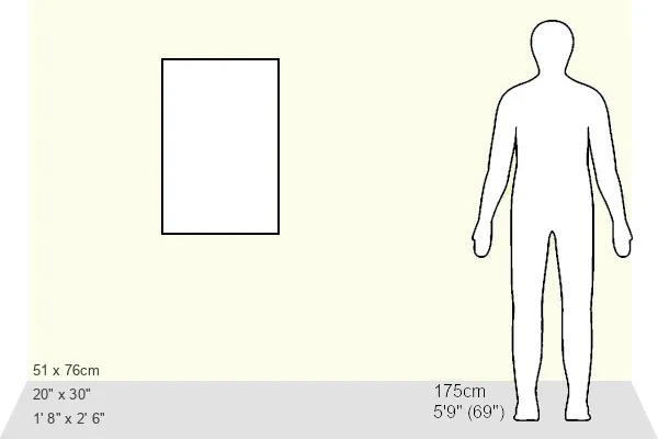
Made in the USA, 1014-piece puzzles measure 20" x 30" (50.8 x 76.2 cm). Every puzzle is meticulously printed on glossy photo paper, which has a strong 1.33 mm thickness. Delivered in a black storage cardboard box, these puzzles are both stylish and practical. (Note: puzzles contain small parts and are not suitable for children under 3 years of age.)
Jigsaw Puzzles are an ideal gift for any occasion
Estimated Product Size is 50.8cm x 76cm (20" x 29.9")
These are individually made so all sizes are approximate
Artwork printed orientated as per the preview above, with portrait (vertical) orientation to match the source image.
EDITORS COMMENTS
This print showcases a detailed map of South Asia from the year 1662. Taken from Johannes Blaeus' renowned "Atlas Major" this particular section focuses on the East Indian archipelago. The map, published in Amsterdam during that time, offers a fascinating glimpse into the geographical knowledge and cartographic skills of the era. The intricate details depicted on this map are truly remarkable. From the vast rivers snaking through the land to various ports dotting the coastline, every element is meticulously illustrated with precision and accuracy. It provides an invaluable historical perspective on how South Asia was perceived and understood over three centuries ago. Johannes Blaeu's "Atlas Major" was highly regarded as one of the most comprehensive atlases of its time, encompassing maps from all corners of the world. This specific detail captures his mastery in cartography while highlighting South Asia's significance within global trade routes during that period. As we delve into this photograph, we are transported back to a time when exploration and discovery were at their peak. It serves as a reminder of our ever-evolving understanding of geography and how it shapes our perception of different regions around the globe. This print by The Granger Collection not only celebrates Johannes Blaeu's artistic talent but also invites us to appreciate South Asia's rich history and cultural heritage through an ancient lens.
MADE IN THE USA
Safe Shipping with 30 Day Money Back Guarantee
FREE PERSONALISATION*
We are proud to offer a range of customisation features including Personalised Captions, Color Filters and Picture Zoom Tools
SECURE PAYMENTS
We happily accept a wide range of payment options so you can pay for the things you need in the way that is most convenient for you
* Options may vary by product and licensing agreement. Zoomed Pictures can be adjusted in the Basket.