Jigsaw Puzzle > Granger Art on Demand > Maps
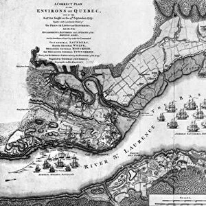
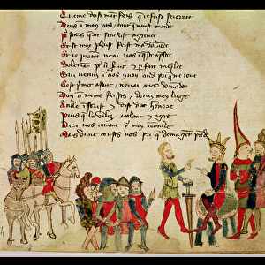
Jigsaw Puzzle : MAP OF NEW FRANCE, 1612. The westerly portion of Samuel de Champlains 1612 map


![]()
Jigsaw Puzzles from Granger
MAP OF NEW FRANCE, 1612. The westerly portion of Samuel de Champlains 1612 map
MAP OF NEW FRANCE, 1612.
The westerly portion of Samuel de Champlains 1612 map of New France
Granger holds millions of images spanning more than 25,000 years of world history, from before the Stone Age to the dawn of the Space Age
Media ID 12321104
1612 Canada Canadian Champlain Colony Detail New France Samuel
Jigsaw Puzzle (1014 Pieces)
Discover the rich history of New France with our captivating jigsaw puzzle from Media Storehouse. This intricately detailed puzzle features the westerly portion of Samuel de Champlains 1612 map of New France, showcasing the unexplored territories of North America as they were first mapped. Bring the past to life as you piece together this beautiful and historically significant image, reprinted from Granger Art on Demand. Engage your mind and transport yourself back in time with our high-quality jigsaw puzzles.
Made in the USA, 1014-piece puzzles measure 20" x 30" (50.8 x 76.2 cm). Every puzzle is meticulously printed on glossy photo paper, which has a strong 1.33 mm thickness. Delivered in a black storage cardboard box, these puzzles are both stylish and practical. (Note: puzzles contain small parts and are not suitable for children under 3 years of age.)
Jigsaw Puzzles are an ideal gift for any occasion
Estimated Product Size is 76cm x 50.8cm (29.9" x 20")
These are individually made so all sizes are approximate
Artwork printed orientated as per the preview above, with landscape (horizontal) orientation to match the source image.
EDITORS COMMENTS
This print showcases the historical significance of Samuel de Champlain's 1612 map of New France. The intricate details and expert craftsmanship of this map transport us back to a time when Canada was still in its early stages of colonization. With a focus on the westerly portion, we can see how Champlain meticulously charted the rivers and territories that would later become integral parts of Canadian history. The map itself is a testament to the French influence in North America during this period. It highlights the French colony's expansion into new territories, as well as their exploration along various river systems. This visual representation allows us to appreciate the immense effort put forth by explorers like Champlain in mapping out uncharted lands. As we gaze upon this remarkable piece, it serves as a reminder of our rich heritage and how far we have come since those early days. It sparks curiosity about what life must have been like for settlers navigating these vast landscapes centuries ago. Granger Art on Demand has beautifully captured this significant artifact, allowing us to bring home a piece of history that continues to shape our understanding of Canada's past. Whether displayed in an educational setting or cherished within your personal collection, this print is sure to spark conversations and ignite imaginations about our nation's fascinating origins.
MADE IN THE USA
Safe Shipping with 30 Day Money Back Guarantee
FREE PERSONALISATION*
We are proud to offer a range of customisation features including Personalised Captions, Color Filters and Picture Zoom Tools
SECURE PAYMENTS
We happily accept a wide range of payment options so you can pay for the things you need in the way that is most convenient for you
* Options may vary by product and licensing agreement. Zoomed Pictures can be adjusted in the Cart.