Jigsaw Puzzle > Granger Art on Demand > Maps
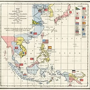
Jigsaw Puzzle : MAP: EUROPE IN ASIA. Map of Asia, English, c1935, emphasizing the territorial acquistitions of the Russian and British Empires up


![]()
Jigsaw Puzzles from Granger
MAP: EUROPE IN ASIA. Map of Asia, English, c1935, emphasizing the territorial acquistitions of the Russian and British Empires up
MAP: EUROPE IN ASIA. Map of Asia, English, c1935, emphasizing the territorial acquistitions of the Russian and British Empires up to 1914
Granger holds millions of images spanning more than 25,000 years of world history, from before the Stone Age to the dawn of the Space Age
Media ID 6617405
1914 Asia British Empire Colonialism Colony Russia Russian
Jigsaw Puzzle (520 Pieces)
Discover the historical intrigue of Europe's colonial past with our captivating jigsaw puzzle from Media Storehouse. Featuring an antique map of Asia from 1935, obtained from Granger Art on Demand, this intricately detailed puzzle showcases the territorial acquisitions of the Russian and British Empires up to 1914. Immerse yourself in the rich history of imperial expansion as you piece together this stunning representation of a bygone era. A perfect activity for history enthusiasts and puzzle lovers alike!
Made in the USA, 520-piece puzzles measure 16" x 20" (40.6 x 50.8 cm). Every puzzle is meticulously printed on glossy photo paper, which has a strong 1.33 mm thickness. Delivered in a black storage cardboard box, these puzzles are both stylish and practical. (Note: puzzles contain small parts and are not suitable for children under 3 years of age.)
Jigsaw Puzzles are an ideal gift for any occasion
Estimated Product Size is 50.8cm x 40.5cm (20" x 15.9")
These are individually made so all sizes are approximate
Artwork printed orientated as per the preview above, with landscape (horizontal) or portrait (vertical) orientation to match the source image.
EDITORS COMMENTS
This print titled "MAP: EUROPE IN ASIA" takes us back to the year 1935, showcasing a historically significant map of Asia. The focus of this English map is on the territorial acquisitions made by two powerful empires - Russia and Britain - leading up to the year 1914. The intricate details depicted in this print highlight the extent of Russian and British colonialism during that era. It serves as a visual reminder of how these empires expanded their influence across vast regions, leaving an indelible mark on Asian history. The map showcases not only political boundaries but also major rivers that played crucial roles in shaping these conquests. As we explore this image, we are transported back in time, witnessing the early stages of Russian expansion into Asia and the strategic moves made by the British Empire to establish colonies throughout the continent. Through this print from The Granger Collection, we gain insight into a pivotal period when global powers sought dominance over new territories. It sparks curiosity about how these imperialistic endeavors impacted both European nations and Asian societies alike. As we delve deeper into this historical artifact, it becomes evident that maps hold immense power in unraveling stories from our past. This particular piece invites us to reflect upon an era defined by exploration, conquests, and geopolitical shifts – ultimately reminding us of Europe's lasting presence within Asia's borders.
MADE IN THE USA
Safe Shipping with 30 Day Money Back Guarantee
FREE PERSONALISATION*
We are proud to offer a range of customisation features including Personalised Captions, Color Filters and Picture Zoom Tools
SECURE PAYMENTS
We happily accept a wide range of payment options so you can pay for the things you need in the way that is most convenient for you
* Options may vary by product and licensing agreement. Zoomed Pictures can be adjusted in the Cart.