Jigsaw Puzzle > Europe > United Kingdom > England > Related Images
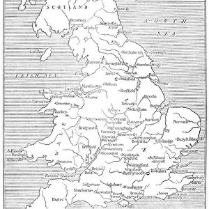
Jigsaw Puzzle : MAP: ENGLAND & WALES. Line engraving, 19th century


![]()
Jigsaw Puzzles From Granger
MAP: ENGLAND & WALES. Line engraving, 19th century
Granger holds millions of images spanning more than 25,000 years of world history, from before the Stone Age to the dawn of the Space Age
Media ID 7553135
Jigsaw Puzzle (520 Pieces)
Discover the beauty and history of England and Wales with our exquisite jigsaw puzzle from Media Storehouse. Featuring a captivating 19th century line engraving of the map by The Granger Collection from Granger Art on Demand, this puzzle invites you on a journey of exploration and learning. With intricate details and vibrant colors, this puzzle is not just a pastime, but an experience that transports you back in time. Immerse yourself in the rich history and culture of England and Wales, piece by piece.
Made in the USA, 520-piece puzzles measure 16" x 20" (40.6 x 50.8 cm). Every puzzle is meticulously printed on glossy photo paper, which has a strong 1.33 mm thickness. Delivered in a black storage cardboard box, these puzzles are both stylish and practical. (Note: puzzles contain small parts and are not suitable for children under 3 years of age.)
Jigsaw Puzzles are an ideal gift for any occasion
Estimated Product Size is 40.5cm x 50.8cm (15.9" x 20")
These are individually made so all sizes are approximate
Artwork printed orientated as per the preview above, with landscape (horizontal) or portrait (vertical) orientation to match the source image.
FEATURES IN THESE COLLECTIONS
> Granger Art on Demand
> Maps
> Europe
> United Kingdom
> England
> Related Images
> Europe
> United Kingdom
> Wales
> Related Images
EDITORS COMMENTS
This print showcases a remarkable piece of history, presenting a meticulously detailed map of England and Wales from the 19th century. The line engraving technique used to create this map adds an exquisite touch, highlighting the intricate craftsmanship that went into its creation. Every county is intricately outlined, allowing us to explore the diverse landscapes and regions that make up these two nations. As we delve into this enchanting depiction, we are transported back in time to an era when cartography was both an art form and a scientific endeavor. The delicate lines etched onto the paper reveal not only geographical features but also provide insight into the cultural and historical significance of each region. From rolling hills to winding rivers, every element on this map tells a story about England and Wales during this period. It invites us to imagine what life was like in bustling cities such as London or picturesque towns nestled amidst breathtaking natural beauty. The inclusion of Wales alongside England emphasizes their interconnectedness while celebrating their unique identities. This print serves as a testament to our shared heritage while honoring the distinctiveness of these two nations. With its timeless charm and attention to detail, "MAP: ENGLAND & WALES" offers viewers an opportunity for exploration and discovery within the rich tapestry of British history. Whether you have personal ties or simply appreciate fine craftsmanship, this print is sure to captivate your imagination with its blend of artistry and geography.
MADE IN THE USA
Safe Shipping with 30 Day Money Back Guarantee
FREE PERSONALISATION*
We are proud to offer a range of customisation features including Personalised Captions, Color Filters and Picture Zoom Tools
SECURE PAYMENTS
We happily accept a wide range of payment options so you can pay for the things you need in the way that is most convenient for you
* Options may vary by product and licensing agreement. Zoomed Pictures can be adjusted in the Basket.