Jigsaw Puzzle > Popular Themes > Politics
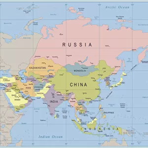
Jigsaw Puzzle : Political map of South East Asia


![]()
Jigsaw Puzzles From Fine Art Storehouse
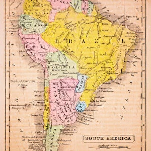
Political map of South East Asia
Vector illustration of the political map of South East Asia
Reference map was created by the US Central Intelligence Agency and is available as a public domain map at the University of Texas Libraries website
Unleash your creativity and transform your space into a visual masterpiece!
Media ID 15192872
Jigsaw Puzzle (520 Pieces)
Discover the intricacies of South East Asia with our captivating Political Jigsaw Puzzle from Media Storehouse, brought to you by the Fine Art Storehouse collection. This meticulously crafted puzzle features a detailed vector illustration of the political map of South East Asia, sourced from the US Central Intelligence Agency. Immerse yourself in the rich cultural diversity and geographical complexity of the region as you piece together this intellectually stimulating puzzle. A perfect addition to your home or office, this puzzle not only offers a fun and engaging activity but also serves as an educational tool for both children and adults alike. Bring South East Asia into your living space and ignite your curiosity with this captivating Political Jigsaw Puzzle from Media Storehouse.
Made in the USA, 520-piece puzzles measure 16" x 20" (40.6 x 50.8 cm). Every puzzle is meticulously printed on glossy photo paper, which has a strong 1.33 mm thickness. Delivered in a black storage cardboard box, these puzzles are both stylish and practical. (Note: puzzles contain small parts and are not suitable for children under 3 years of age.)
Jigsaw Puzzles are an ideal gift for any occasion
Estimated Product Size is 40.5cm x 50.8cm (15.9" x 20")
These are individually made so all sizes are approximate
Artwork printed orientated as per the preview above, with landscape (horizontal) or portrait (vertical) orientation to match the source image.
FEATURES IN THESE COLLECTIONS
> Maps and Charts
> Related Images
EDITORS COMMENTS
This print showcases a meticulously detailed political map of South East Asia, rendered in stunning vector illustration. Every intricate border and geographical feature is expertly depicted, offering an immersive visual experience for any admirer of cartography. The reference map used as the basis for this artwork was originally created by the US Central Intelligence Agency and is now available as a public domain resource at the esteemed University of Texas Libraries website. This ensures its accuracy and reliability, making it an invaluable tool for scholars, researchers, or anyone with a keen interest in exploring the diverse nations that comprise this vibrant region. From Indonesia's sprawling archipelago to Vietnam's elongated coastline; from Thailand's lush jungles to Malaysia's modern metropolises - all are beautifully represented on this print. The delicate balance between land and sea is artfully captured, showcasing not only national boundaries but also major rivers, mountain ranges, and other natural landmarks that shape these countries' identities. Whether displayed in a classroom setting or proudly hung on your own wall at home, this print serves as both an educational resource and a striking piece of art. It invites viewers to embark on their own mental journey through South East Asia - unraveling its rich history, cultural diversity, and geopolitical dynamics one glance at a time.
MADE IN THE USA
Safe Shipping with 30 Day Money Back Guarantee
FREE PERSONALISATION*
We are proud to offer a range of customisation features including Personalised Captions, Color Filters and Picture Zoom Tools
SECURE PAYMENTS
We happily accept a wide range of payment options so you can pay for the things you need in the way that is most convenient for you
* Options may vary by product and licensing agreement. Zoomed Pictures can be adjusted in the Basket.