Fraud Blocker Skip to main content

Home > South America > Brazil > Maps

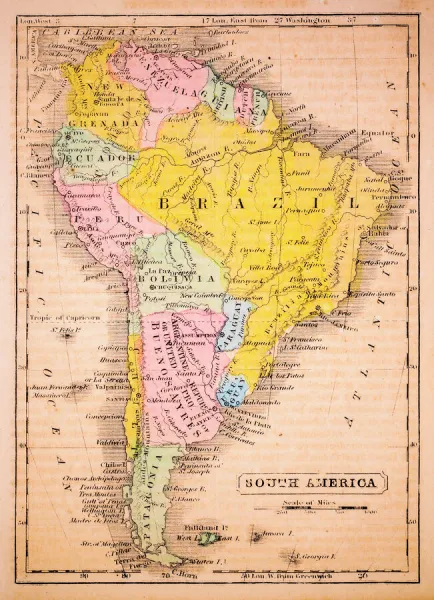
South America 1852 Map

 : South America 1852 Map
Sold 1
In Stock
We accept all major payment options so you can pay for the things you need in the way that is most convenient for you

Choose Your Product

Framed Photos
Buy from $79.99
Photo Prints
Buy from $9.99
Jigsaw Puzzles
Buy from $39.99
Poster Prints
Buy from $24.99
Canvas Prints
Buy from $99.99
Fine Art Prints
Buy from $60.90
Metal Prints
Buy from $169.99
Home Decor
Buy from $16.99

Fine Art Storehouse Photo Prints and Wall Art

South America 1852 Map

South America 1852 Map. Unleash your creativity and transform your space into a visual masterpiece. © benoitb

benoitb

Media ID 13666889

Argentina Atlantic Ocean Bolivia Brazil Caribbean Sea Chile Color Swatch Ecuador Geographic Map Grenada Line Art Pacific Ocean Paraguay Patagonia Argentina Patagonia Chile Peru Sketch South America The Americas Uruguay Venezuela Art And Craft Cartography Classical Style Drawing Art Product Guiana Highlands Retro Styled Victorian Style

FEATURES IN THESE COLLECTIONS

> Europe > United Kingdom > Scotland > Highlands > Related Images

> Fine Art Storehouse > Map > Historical Maps

> Fine Art Storehouse > Map

> Fine Art Storehouse > Travel Imagery > Travel Destinations > patagonia

> Maps and Charts > Americas

> North America > Grenada > Maps

> North America > Grenada > Related Images

> South America > Argentina > Maps

> South America > Argentina > Related Images

> South America > Bolivia > Maps

> South America > Bolivia > Related Images

> South America > Brazil > Maps

> South America > Brazil > Related Images

SECURE PAYMENTS
We accept all major payment options so you can pay for the things you need in the way that is most convenient for you

Made in USA
Safe Shipping, Easy Returns

FREE PERSONALISATION
We are proud to offer a range of customisation including Cropping, Captions, and Filters. Zoom Cropping can be adjusted in the basket


EDITORS COMMENTS

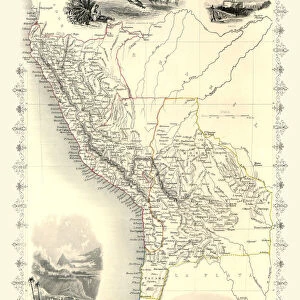
This print takes us back in time to the year 1852, offering a glimpse into the intricate cartography of South America during that era. With its retro-styled design and 19th-century aesthetic, this painted image transports us to a bygone era of exploration and discovery. The artist's skilled sketching and line art techniques bring this antique map to life, showcasing the physical geography of South America in stunning detail. From the majestic Guiana Highlands to the vibrant colors of Grenada, Venezuela, Uruguay, Peru, Paraguay, Chilean Patagonia, Brazil, Ecuador, Bolivia, Argentinean Patagonia; every corner of this diverse continent is beautifully illustrated. With its Victorian and classical influences evident in every stroke of ink-engraved lines and carefully chosen color swatches; this illustration exudes an air of history and elegance. The map showcases not only the vastness of South America but also highlights its geographical features such as rivers meandering through lush landscapes. As we admire this piece from Benoitb's collection at Fine Art Storehouse; it serves as a reminder that maps are not merely tools for navigation but works of art that encapsulate our understanding and appreciation for different regions. Whether you're a history enthusiast or an admirer of fine craftsmanship; this vertical drawing art product will surely transport you on a visual journey across South America's rich tapestry while evoking curiosity about its past.


Framed Prints of South America 1852 Map

Step back in time with our beautifully framed South America 1852 Map from Benoitb at Media Storehouse. This exquisite piece of historical cartography showcases the intricate details of South America as it appeared over 160 years ago. Meticulously preserved and presented in a durable frame, this framed print adds a touch of vintage charm and intellectual sophistication to any room in your home or office. Delve into the rich history of South America and transport yourself back in time with this captivating piece from our Fine Art Storehouse collection.


Photo Prints of South America 1852 Map

Step back in time with our exquisite 'South America 1852 Map' print from Benoitb's Fine Art Collection at Media Storehouse. This captivating piece transports you to an era of exploration and discovery, with intricate detailing of borders, geographical features, and historical annotations. Perfectly preserved, this print is not just a map, but a window to the past. Decorate your walls with a piece of history and ignite the wanderlust within you.


Poster Prints of South America 1852 Map

"Discover the wonders of South America's past with our exquisite poster print of the "South America 1852 Map" from Benoitb's Fine Art Storehouse collection. This captivating vintage map transports you back in time, showcasing the intricate details of South America's geography as it appeared over 160 years ago. Perfectly suited for history enthusiasts, world travelers, or anyone with a passion for antique cartography, this stunning poster print makes a unique and thoughtful addition to any room in your home or office. Bring a piece of history to life and embellish your space with this beautiful work of art."


Jigsaw Puzzles of South America 1852 Map

Discover the rich history of South America with our captivating jigsaw puzzle from Media Storehouse, featuring the intricately detailed 1852 Map of South America by benoitb from Fine Art Storehouse. Transport yourself back in time as you piece together this beautiful work of art, revealing the political boundaries and geographical features of the region as it existed over 160 years ago. A perfect activity for history buffs, puzzle enthusiasts, or anyone seeking an engaging and educational pastime.

diamond
Made With High Grade Materials
thumb_up
Professional Quality Finish
package_2
Carefully Packed To Aid Safe Arrival

You May Also Like


Political map of South AmericaPolitical map of South America
Add to Basket
Map of South America 1895Map of South America 1895
Add to Basket
South America Cartoon MapSouth America Cartoon Map
Add to Basket
Map of Middle East - illustrationMap of Middle East - illustration
Add to Basket
Political map of South East AsiaPolitical map of South East Asia
Add to Basket
Physical map of South AmericaPhysical map of South America
Add to Basket
Africa Political MapAfrica Political Map
Add to Basket
Asia Map - illustrationAsia Map - illustration
Add to Basket
Map Of South America, 1899Map Of South America, 1899
Add to Basket
Map of AustraliaMap of Australia
Add to Basket
South America map countries and citiesSouth America map countries and cities
Add to Basket
Australia and pacific islands map 1898Australia and pacific islands map 1898
Add to Basket

Gallery Wall Inspiration

Autumn view of Patagonia with Mount Fitzroy background
South America 1852 Map
Mount Fitz Roy, Patagonia, Argentina
Within the Marble Caves of Northern Patagonia
Argentina, Rio Pinturas, Cueva de los Manos, imprints of human hands on rock
Puyehue volcano in the evening light, Puyehue, Los Lagos Region, Chile
Sunset lenticular and cumulus clouds, Patagonia, AR
Osorno volcano, at the front a Chilean Firebush, also Notro or Ciruelillo -Embothrium coccineum-, Puerto Varas, Los Lagos Region, Chile
Dried seaweed, Puerto Montt, Los Lagos Region, Chile
Poplars, the Chilean Andes at the back, on the Rio Chacabuco river, Cochrane, Region de Aysen, Patagonia, Chile, South America, America
Torres del Paine National Park, Chile
Perito Moreno Glacier
Panorama of sunrise at Cerro Torre with ice floes
Sunrise in the Patagonian Andes Mountains
Milky way over Torres del paine national park at twilight, patagonia, Chile
Chile, Patagonia, Torres del Paine National Park
Torres del Paine National Park, Chilean Patagonia
Mountain peaks of North and South America, woodcut, published 1893
Argentina, Patagonia Los Glaciares National Park
Milky Way at Lago Pehoe, Torres del Paine National Park
Patagonia Mountain
Starry night over Cerro Torre. Patagonia, Argentina
Andean condor in Patagonia
Historical map of Argentina, wood engraving, published in 1893
Antique Map of the East Coast of Patagonia
Fitzroy and river curve
Mount Fitz Roy at dawn. Argentina, Patagonia

Discover Our Collections


MapMap
View Collection
Argentina Related ImagesArgentina Related Images
View Collection
Bolivia Related ImagesBolivia Related Images
View Collection
Brazil Related ImagesBrazil Related Images
View Collection
Grenada Related ImagesGrenada Related Images
View Collection
MapsMaps
View Collection
MapsMaps
View Collection
MapsMaps
View Collection
MapsMaps
View Collection
Highlands Related ImagesHighlands Related Images
View Collection
AmericasAmericas
View Collection
patagoniapatagonia
View Collection
Historical MapsHistorical Maps
View Collection


© Copyright Media Storehouse, All Rights Reserved 2003 - 2025
Facebook     Pinterest     100% Payment Secure     Reviews IO