Fine Art Print > Arts > Artists > O > Oceanic Oceanic
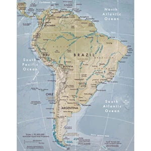
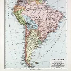
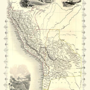
Fine Art Print : South America 1852 Map


![]()
Fine Art Prints from Fine Art Storehouse
South America 1852 Map
Unleash your creativity and transform your space into a visual masterpiece!
benoitb
Media ID 13666889
© benoitb
Argentina Atlantic Ocean Bolivia Brazil Caribbean Sea Chile Color Swatch Ecuador Geographic Map Line Art Pacific Ocean Paraguay Patagonia Argentina Patagonia Chile Peru Sketch South America The Americas Uruguay Venezuela Classical Style Drawing Art Product Grenada Guiana Highlands Painted Image Retro Styled Victorian Style
20"x16" (+3" Border) Fine Art Print
Discover the rich history of South America with our exquisite South America 1852 Map fine art print from Benoitb's collection at Media Storehouse. This stunning vintage map transports you back in time, capturing the essence of exploration and discovery. With intricate detail and beautiful cartography, this fine art print makes a captivating addition to any home or office space. Bring a piece of history into your world and elevate your decor with this timeless masterpiece.
20x16 image printed on 26x22 Fine Art Rag Paper with 3" (76mm) white border. Our Fine Art Prints are printed on 300gsm 100% acid free, PH neutral paper with archival properties. This printing method is used by museums and art collections to exhibit photographs and art reproductions.
Our fine art prints are high-quality prints made using a paper called Photo Rag. This 100% cotton rag fibre paper is known for its exceptional image sharpness, rich colors, and high level of detail, making it a popular choice for professional photographers and artists. Photo rag paper is our clear recommendation for a fine art paper print. If you can afford to spend more on a higher quality paper, then Photo Rag is our clear recommendation for a fine art paper print.
Estimated Image Size (if not cropped) is 36.7cm x 50.8cm (14.4" x 20")
Estimated Product Size is 55.9cm x 66cm (22" x 26")
These are individually made so all sizes are approximate
Artwork printed orientated as per the preview above, with portrait (vertical) orientation to match the source image.
FEATURES IN THESE COLLECTIONS
> Arts
> Artists
> O
> Oceanic Oceanic
> Arts
> Landscape paintings
> Waterfall and river artworks
> River artworks
> Europe
> United Kingdom
> Scotland
> Highlands
> Related Images
> Maps and Charts
> Related Images
> North America
> Grenada
> Maps
> North America
> Grenada
> Related Images
> South America
> Argentina
> Maps
> South America
> Argentina
> Related Images
> South America
> Bolivia
> Maps
> Fine Art Storehouse
> Map
> Historical Maps
> Fine Art Storehouse
> Travel Imagery
> Travel Destinations
> patagonia
EDITORS COMMENTS
This print takes us back in time to the year 1852, offering a glimpse into the intricate cartography of South America during that era. With its retro-styled design and 19th-century aesthetic, this painted image transports us to a bygone era of exploration and discovery. The artist's skilled sketching and line art techniques bring this antique map to life, showcasing the physical geography of South America in stunning detail. From the majestic Guiana Highlands to the vibrant colors of Grenada, Venezuela, Uruguay, Peru, Paraguay, Chilean Patagonia, Brazil, Ecuador, Bolivia, Argentinean Patagonia; every corner of this diverse continent is beautifully illustrated. With its Victorian and classical influences evident in every stroke of ink-engraved lines and carefully chosen color swatches; this illustration exudes an air of history and elegance. The map showcases not only the vastness of South America but also highlights its geographical features such as rivers meandering through lush landscapes. As we admire this piece from Benoitb's collection at Fine Art Storehouse; it serves as a reminder that maps are not merely tools for navigation but works of art that encapsulate our understanding and appreciation for different regions. Whether you're a history enthusiast or an admirer of fine craftsmanship; this vertical drawing art product will surely transport you on a visual journey across South America's rich tapestry while evoking curiosity about its past.
MADE IN THE USA
Safe Shipping with 30 Day Money Back Guarantee
FREE PERSONALISATION*
We are proud to offer a range of customisation features including Personalised Captions, Color Filters and Picture Zoom Tools
SECURE PAYMENTS
We happily accept a wide range of payment options so you can pay for the things you need in the way that is most convenient for you
* Options may vary by product and licensing agreement. Zoomed Pictures can be adjusted in the Cart.