Jigsaw Puzzle > Europe > Austria > Sports > Skiing
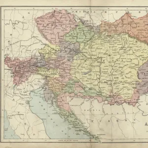
Jigsaw Puzzle : Tyrol map 1895


![]()
Jigsaw Puzzles From Fine Art Storehouse
Tyrol map 1895
Meyers Konversations-Lexikon. Ein Nachschlagewerk des allgemeinen Wissens, 5th edition 17 volumes Bibliographisches Institut - Leipzig 1895-1897
Unleash your creativity and transform your space into a visual masterpiece!
THEPALMER
Media ID 13609323
© This content is subject to copyright
Alps Austria European Alps Innsbruck Resorts Tirol Tyrol Tyrol State
Jigsaw Puzzle (520 Pieces)
Discover the captivating world of history with our Media Storehouse Jigsaw Puzzle featuring the intricately detailed "Tyrol Map 1895" by THEPALmer from the Fine Art Storehouse. This exquisite puzzle, inspired by the Meyers Konversations-Lexikon, 5th edition, transports you back in time to an era of exploration and cartography. With each piece, you'll uncover the intricacies of this historical map, meticulously recreated for your enjoyment. Puzzle assembly not only provides an engaging and rewarding experience, but it also offers a unique opportunity to connect with the past. Immerse yourself in the rich history of Tyrol in the late 19th century, piece by piece.
Made in the USA, 520-piece puzzles measure 16" x 20" (40.6 x 50.8 cm). Every puzzle is meticulously printed on glossy photo paper, which has a strong 1.33 mm thickness. Delivered in a black storage cardboard box, these puzzles are both stylish and practical. (Note: puzzles contain small parts and are not suitable for children under 3 years of age.)
Jigsaw Puzzles are an ideal gift for any occasion
Estimated Product Size is 50.8cm x 40.5cm (20" x 15.9")
These are individually made so all sizes are approximate
Artwork printed orientated as per the preview above, with landscape (horizontal) or portrait (vertical) orientation to match the source image.
FEATURES IN THESE COLLECTIONS
> Fine Art Storehouse
> Map
> Historical Maps
> Europe
> Austria
> Innsbruck
> Europe
> Austria
> Related Images
> Europe
> Austria
> Sports
> Skiing
> Maps and Charts
> Related Images
EDITORS COMMENTS
This print takes us back in time to the year 1895, showcasing a meticulously detailed map of Tyrol. Derived from Meyers Konversations-Lexikon, a renowned encyclopedia of general knowledge during that era, this antique piece offers a glimpse into the rich history and geography of the region. The Tyrol state, nestled amidst the majestic European Alps in Austria, is beautifully depicted with intricate engravings and etchings. The map serves as an invaluable resource for those intrigued by physical geography and cartography. It unveils not only the geographical features but also highlights various resorts and ski destinations scattered across Tyrol's picturesque landscape. Innsbruck, known for its stunning alpine scenery and vibrant culture, stands out prominently on this historical document. As we admire this horizontal artwork, it transports us to a time when technology had yet to shape our world. Its vintage charm evokes nostalgia while reminding us of how far we have come since then. This print by THEPALMER captures every minute detail with precision and showcases their passion for preserving historical artifacts. Whether you are an avid collector or simply fascinated by old-world charm, this exquisite illustration promises to be a cherished addition to any space it graces. Let your imagination wander through time as you explore the wonders of Tyrol through this remarkable piece of art.
MADE IN THE USA
Safe Shipping with 30 Day Money Back Guarantee
FREE PERSONALISATION*
We are proud to offer a range of customisation features including Personalised Captions, Color Filters and Picture Zoom Tools
SECURE PAYMENTS
We happily accept a wide range of payment options so you can pay for the things you need in the way that is most convenient for you
* Options may vary by product and licensing agreement. Zoomed Pictures can be adjusted in the Basket.