Home > Europe > Austria > Innsbruck
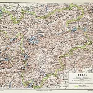
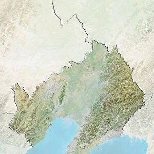
State of Tyrol, Austria, Relief Map

![]()
Wall Art and Photo Gifts from Universal Images Group (UIG)
State of Tyrol, Austria, Relief Map
Relief map of the State of Tyrol, Austria. This image was compiled from data acquired by LANDSAT 5 & 7 satellites combined with elevation data
Universal Images Group (UIG) manages distribution for many leading specialist agencies worldwide
Media ID 9613219
© Planet Observer/UIG
Alps Austria Innsbruck Mountain Mountain Range Relief Map State Tyrol Satellite View
FEATURES IN THESE COLLECTIONS
> Aerial Photography
> Austria
> Europe
> Austria
> Innsbruck
> Universal Images Group (UIG)
> Universal Images Group
> Satellite and Aerial
> Planet Observer 4
EDITORS COMMENTS
This print showcases the stunning State of Tyrol in Austria, as depicted through a relief map. Created by combining data acquired from LANDSAT 5 & 7 satellites with elevation information, this image offers a detailed and accurate representation of the region's topography. The majestic Alps dominate the landscape, forming an impressive mountain range that stretches across the state. Innsbruck, the capital city of Tyrol, can also be seen on this horizontal photograph. The vibrant colors bring life to this otherwise untouched natural beauty. With no people in sight, one can fully appreciate the unspoiled grandeur of Tyrol's physical geography. This satellite view allows us to explore every contour and peak with awe-inspiring precision. Cartography enthusiasts will find delight in studying this meticulously crafted relief map. It serves as both an educational tool and a work of art, showcasing the intricate details that make up Tyrol's diverse terrain. As we gaze upon this image, we are transported to Europe's heartland where nature reigns supreme. Whether you're planning your next adventure or simply appreciating Earth's wonders from afar, let this print immerse you in the breathtaking landscapes that define Tyrol—an enchanting destination for any lover of mountains and outdoor exploration.
MADE IN THE USA
Safe Shipping with 30 Day Money Back Guarantee
FREE PERSONALISATION*
We are proud to offer a range of customisation features including Personalised Captions, Color Filters and Picture Zoom Tools
SECURE PAYMENTS
We happily accept a wide range of payment options so you can pay for the things you need in the way that is most convenient for you
* Options may vary by product and licensing agreement. Zoomed Pictures can be adjusted in the Cart.