Jigsaw Puzzle > Europe > France > Canton > Landes
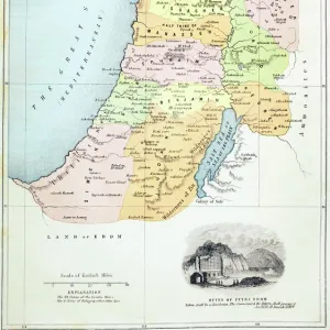
Jigsaw Puzzle : Antique map of Israel


![]()
Jigsaw Puzzles from Fine Art Storehouse
Antique map of Israel
Unleash your creativity and transform your space into a visual masterpiece!
Hemera Technologies
Media ID 13609415
© Getty Images
Border Coordinates Data Direction Document Geography Holy Land Israel Legend Location Mediterranean Sea Middle East Place Positioning Scale Scene Text Words
Jigsaw Puzzle (520 Pieces)
Discover the rich history of Israel with our captivating Antique Map of Israel jigsaw puzzle from the Media Storehouse collection, brought to you by Fine Art Storehouse and Hemera Technologies. This intricately detailed puzzle features an authentic antique map depicting the historical lands and borders of Israel. Immerse yourself in the intrigue of piecing together this beautiful and educational puzzle, perfect for all ages and skill levels. Transport yourself back in time as you connect the past with the present, creating a unique and engaging experience for you and your family. Engage your mind, stimulate your creativity, and add a touch of history to your home with the Antique Map of Israel jigsaw puzzle from Media Storehouse.
Made in the USA, 520-piece puzzles measure 16" x 20" (40.6 x 50.8 cm). Every puzzle is meticulously printed on glossy photo paper, which has a strong 1.33 mm thickness. Delivered in a black storage cardboard box, these puzzles are both stylish and practical. (Note: puzzles contain small parts and are not suitable for children under 3 years of age.)
Jigsaw Puzzles are an ideal gift for any occasion
Estimated Product Size is 50.8cm x 40.5cm (20" x 15.9")
These are individually made so all sizes are approximate
Artwork printed orientated as per the preview above, with landscape (horizontal) or portrait (vertical) orientation to match the source image.
FEATURES IN THESE COLLECTIONS
> Fine Art Storehouse
> Map
> Historical Maps
> Asia
> Israel
> Related Images
> Europe
> France
> Canton
> Landes
> Maps and Charts
> Early Maps
> Maps and Charts
> Related Images
EDITORS COMMENTS
This antique map of Israel takes us on a journey back in time, offering a glimpse into the rich history and geography of this holy land. The print, created by Hemera Technologies, showcases intricate details that transport us to another era. The warm hues and delicate engravings evoke a sense of nostalgia as we explore the borders, coordinates, and legends carefully inscribed on this archival document. With its horizontal orientation, the map effortlessly guides our eyes across its vast Mediterranean Sea coastline and Middle Eastern surroundings. As we study each word meticulously placed on this vintage piece, we uncover not only physical geography but also historical significance. The key provides essential information for deciphering the symbols scattered throughout the scene while allowing us to understand the positioning of various landmarks. Through this mesmerizing artwork, we embark on an educational voyage through time. It serves as a reminder of how maps were once vital tools for navigation and exploration. This particular map invites contemplation about ancient civilizations that thrived in these lands centuries ago. While no people are present within this color image captured by Hemera Technologies' skilled photography, it is impossible not to feel connected with those who have walked these historic grounds before us. This print is more than just a decorative piece; it is an invitation to immerse ourselves in Israel's past and appreciate its cultural heritage from afar.
MADE IN THE USA
Safe Shipping with 30 Day Money Back Guarantee
FREE PERSONALISATION*
We are proud to offer a range of customisation features including Personalised Captions, Color Filters and Picture Zoom Tools
SECURE PAYMENTS
We happily accept a wide range of payment options so you can pay for the things you need in the way that is most convenient for you
* Options may vary by product and licensing agreement. Zoomed Pictures can be adjusted in the Cart.