Jigsaw Puzzle > Fine Art Storehouse > Map
Jigsaw Puzzle : Antique damaged map of Holland & Belgium 19th Century


![]()
Jigsaw Puzzles from Fine Art Storehouse
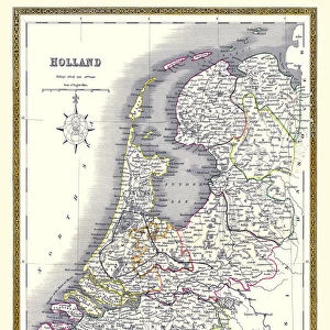
Antique damaged map of Holland & Belgium 19th Century
Vintage engraving of a Antique damaged map of Holland & Belgium in the 19th Century, 1873
Unleash your creativity and transform your space into a visual masterpiece!
duncan1890
Media ID 13609235
© This content is subject to copyright
1870 1879 Bad Condition Belgium Benelux Colour Colours Condition Damaged Equipment Faded Holland Image Created 1870 1879 Navigational Equipment Netherlands Northern Europe Retro Styles Supplies Victorian Retro Styled Victorian Style
Jigsaw Puzzle (520 Pieces)
Discover the charm of the past with our Antique damaged map of Holland & Belgium 19th Century jigsaw puzzle from the Media Storehouse collection. This intricately detailed puzzle, inspired by a vintage engraving from the Fine Art Storehouse by duncan1890, dates back to 1873. Immerse yourself in history as you piece together this beautiful and damaged map of Holland and Belgium from the 19th century. With each completed section, the story of the past comes to life. Perfect for puzzle enthusiasts, history buffs, or anyone looking for a captivating and educational activity. Bring the rich history of this region into your home with our Antique damaged map of Holland & Belgium 19th Century jigsaw puzzle.
Made in the USA, 520-piece puzzles measure 16" x 20" (40.6 x 50.8 cm). Every puzzle is meticulously printed on glossy photo paper, which has a strong 1.33 mm thickness. Delivered in a black storage cardboard box, these puzzles are both stylish and practical. (Note: puzzles contain small parts and are not suitable for children under 3 years of age.)
Jigsaw Puzzles are an ideal gift for any occasion
Estimated Product Size is 40.5cm x 50.8cm (15.9" x 20")
These are individually made so all sizes are approximate
Artwork printed orientated as per the preview above, with landscape (horizontal) or portrait (vertical) orientation to match the source image.
FEATURES IN THESE COLLECTIONS
> Fine Art Storehouse
> Map
> Historical Maps
EDITORS COMMENTS
This print showcases an antique damaged map of Holland & Belgium from the 19th century. The vintage engraving, created in 1873, exudes a sense of history and nostalgia. Despite its bad condition, this map tells a tale of European cartography and navigational equipment used during that era. The faded colors and worn-out appearance add to its charm, transporting us back to a time when old-fashioned styles prevailed. This vertical image captures the essence of the past with its Victorian-style illustration and painting techniques. As we gaze upon this archival piece, we are reminded of the rich history embedded within these lands. From Belgium's vibrant cities to Holland's picturesque landscapes, every detail on this map holds significance. Although damaged by time, it serves as a testament to human curiosity and exploration throughout Northern Europe. Its presence evokes feelings of wonderment as we ponder how our ancestors relied on such supplies for their journeys. Duncan1890 has masterfully captured this vintage gem through his lens, preserving not only the physicality but also the emotions associated with it. This print is perfect for those who appreciate historical artifacts and seek to bring a touch of retro elegance into their space.
MADE IN THE USA
Safe Shipping with 30 Day Money Back Guarantee
FREE PERSONALISATION*
We are proud to offer a range of customisation features including Personalised Captions, Color Filters and Picture Zoom Tools
SECURE PAYMENTS
We happily accept a wide range of payment options so you can pay for the things you need in the way that is most convenient for you
* Options may vary by product and licensing agreement. Zoomed Pictures can be adjusted in the Cart.