Jigsaw Puzzle > North America > Canada > Maps
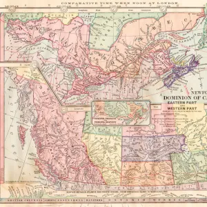
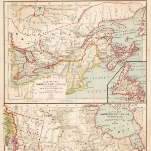
Jigsaw Puzzle : 1883 Dominion Of Canada Map


![]()
Jigsaw Puzzles from Fine Art Storehouse
1883 Dominion Of Canada Map
1883 Dominion Of Canada Map/ British America
Unleash your creativity and transform your space into a visual masterpiece!
benoitb
Media ID 19332769
© benoitb
Jigsaw Puzzle (520 Pieces)
Discover the historical charm of the past with our 1883 Dominion of Canada Map jigsaw puzzle from Benoitb at Media Storehouse. This intricately detailed puzzle features a vintage map of British North America from the year 1883, showcasing the Dominion of Canada in its early stages. Transport yourself back in time as you piece together this captivating puzzle, perfect for history enthusiasts, puzzle collectors, or anyone looking for a challenging and rewarding activity. Bring this piece of Canadian history to life in your home, one puzzle piece at a time.
Made in the USA, 520-piece puzzles measure 16" x 20" (40.6 x 50.8 cm). Every puzzle is meticulously printed on glossy photo paper, which has a strong 1.33 mm thickness. Delivered in a black storage cardboard box, these puzzles are both stylish and practical. (Note: puzzles contain small parts and are not suitable for children under 3 years of age.)
Jigsaw Puzzles are an ideal gift for any occasion
Estimated Product Size is 50.8cm x 40.5cm (20" x 15.9")
These are individually made so all sizes are approximate
Artwork printed orientated as per the preview above, with landscape (horizontal) or portrait (vertical) orientation to match the source image.
FEATURES IN THESE COLLECTIONS
> Fine Art Storehouse
> Map
> Historical Maps
> Maps and Charts
> Related Images
> North America
> Canada
> Maps
> North America
> Canada
> Related Images
EDITORS COMMENTS
This print showcases the intricate details of the 1883 Dominion of Canada Map, a true masterpiece in cartography. With its retro revival aesthetic, this piece takes us back to an era when map-making was both an art form and a scientific endeavor. The artist, Benoitb, has skillfully captured every contour and boundary line with precision and finesse. The map itself is a fascinating glimpse into the past, depicting British America during that time period. From the majestic Mt Athabasca to the vast expanses of Labrador and the Gulf of St Lawrence, this map offers a comprehensive view of Canada's geographical landscape over a century ago. As we gaze upon this print, we are transported to an age where exploration and discovery were at their peak. It serves as a reminder of our rich history and how far we have come as a nation. The attention to detail in this artwork is truly remarkable; each stroke tells a story about our country's heritage. Whether you're an avid collector or simply appreciate fine art, this print is sure to captivate your imagination. Hang it proudly on your wall or gift it to someone who shares your passion for history and geography. Let this stunning piece be a conversation starter that sparks curiosity about our past while adding timeless beauty to any space it graces.
MADE IN THE USA
Safe Shipping with 30 Day Money Back Guarantee
FREE PERSONALISATION*
We are proud to offer a range of customisation features including Personalised Captions, Color Filters and Picture Zoom Tools
SECURE PAYMENTS
We happily accept a wide range of payment options so you can pay for the things you need in the way that is most convenient for you
* Options may vary by product and licensing agreement. Zoomed Pictures can be adjusted in the Cart.