Jigsaw Puzzle > North America > United States of America > New York > New York > Maps
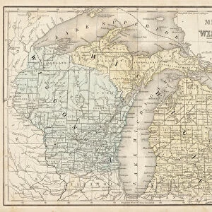
Jigsaw Puzzle : Wisconsin Michigan map 1881


![]()
Jigsaw Puzzles from Fine Art Storehouse
Wisconsin Michigan map 1881
Coltons Common School Geography 1881 New York Sheldon and Co
Unleash your creativity and transform your space into a visual masterpiece!
THEPALMER
Media ID 13669253
© This content is subject to copyright
American Culture Globe Navigational Equipment Michigan North America Paper Planet Earth Wisconsin World Map
Jigsaw Puzzle (520 Pieces)
Discover the rich history of American geography with our exquisite Wisconsin Michigan map jigsaw puzzle from ThePalmer's Fine Art Storehouse. This intriguing puzzle, inspired by Colton's Common School Geography published by Sheldon and Co in 1881, invites you on a captivating journey back in time. With intricate details and vibrant colors, each piece of this jigsaw puzzle brings the historical map to life, allowing you to explore the landscapes and borders of Wisconsin and Michigan as they appeared over a century ago. Ideal for puzzle enthusiasts, history buffs, or anyone looking for a stimulating and rewarding pastime, this Wisconsin Michigan map puzzle is a must-have addition to your collection.
Made in the USA, 520-piece puzzles measure 16" x 20" (40.6 x 50.8 cm). Every puzzle is meticulously printed on glossy photo paper, which has a strong 1.33 mm thickness. Delivered in a black storage cardboard box, these puzzles are both stylish and practical. (Note: puzzles contain small parts and are not suitable for children under 3 years of age.)
Jigsaw Puzzles are an ideal gift for any occasion
Estimated Product Size is 40.5cm x 50.8cm (15.9" x 20")
These are individually made so all sizes are approximate
Artwork printed orientated as per the preview above, with landscape (horizontal) or portrait (vertical) orientation to match the source image.
FEATURES IN THESE COLLECTIONS
> Fine Art Storehouse
> The Magical World of Illustration
> Palmer Illustrated Collection
> Fine Art Storehouse
> Map
> Historical Maps
> Fine Art Storehouse
> Map
> USA Maps
> Maps and Charts
> Related Images
> Maps and Charts
> World
> North America
> Related Images
> North America
> United States of America
> Maps
> North America
> United States of America
> Michigan
> Related Images
> North America
> United States of America
> New York
> New York
> Maps
> North America
> United States of America
> New York
> Related Images
> North America
> United States of America
> Wisconsin
> Related Images
> Science
> Space Exploration
> Planets
> Earth
EDITORS COMMENTS
This print titled "Wisconsin Michigan map 1881" takes us back in time to the late 19th century, when cartography was a meticulous art form. The image showcases an intricately detailed map from Coltons Common School Geography of 1881, published by Sheldon and Co in New York. The vintage charm of this piece is evident through its aged paper texture and engraved illustration style. The artist skillfully captures the physical geography of both Wisconsin and Michigan, two states nestled within the vast continent of North America. As we gaze upon this antique map, we are reminded of the rich history and cultural significance that these regions hold. The presence of globe navigational equipment adds an extra layer of intrigue to the composition, symbolizing exploration and discovery during a time when our understanding of planet Earth was expanding rapidly. This particular print serves as a testament to American culture at that era - one deeply rooted in curiosity about our surroundings. Whether you're a history enthusiast or simply appreciate fine art with historical context, "Wisconsin Michigan map 1881" offers a unique glimpse into the past while showcasing the beauty found within old maps' intricate details. THEPALMER's expert capture ensures that this piece will be cherished for years to come as it transports us back to an era where cartography reigned supreme.
MADE IN THE USA
Safe Shipping with 30 Day Money Back Guarantee
FREE PERSONALISATION*
We are proud to offer a range of customisation features including Personalised Captions, Color Filters and Picture Zoom Tools
SECURE PAYMENTS
We happily accept a wide range of payment options so you can pay for the things you need in the way that is most convenient for you
* Options may vary by product and licensing agreement. Zoomed Pictures can be adjusted in the Cart.