Fine Art Print > North America > United States of America > New York > New York > Maps
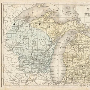
Fine Art Print : Wisconsin Michigan map 1881


![]()
Fine Art Prints from Fine Art Storehouse
Wisconsin Michigan map 1881
Coltons Common School Geography 1881 New York Sheldon and Co
Unleash your creativity and transform your space into a visual masterpiece!
THEPALMER
Media ID 13669253
© This content is subject to copyright
American Culture Globe Navigational Equipment Michigan North America Paper Planet Earth Wisconsin World Map
20"x16" (+3" Border) Fine Art Print
Step back in time with this exquisite Fine Art Print of the Wisconsin-Michigan Map from ThePalmer, published by Colton's Common School Geography in 1881. This vintage map, originally printed by Sheldon and Co. in New York, showcases intricate detail and historical accuracy. Bring a touch of nostalgia and elegance to your home or office with this beautiful piece of cartographic history.
20x16 image printed on 26x22 Fine Art Rag Paper with 3" (76mm) white border. Our Fine Art Prints are printed on 300gsm 100% acid free, PH neutral paper with archival properties. This printing method is used by museums and art collections to exhibit photographs and art reproductions.
Our fine art prints are high-quality prints made using a paper called Photo Rag. This 100% cotton rag fibre paper is known for its exceptional image sharpness, rich colors, and high level of detail, making it a popular choice for professional photographers and artists. Photo rag paper is our clear recommendation for a fine art paper print. If you can afford to spend more on a higher quality paper, then Photo Rag is our clear recommendation for a fine art paper print.
Estimated Image Size (if not cropped) is 40.6cm x 47.4cm (16" x 18.7")
Estimated Product Size is 55.9cm x 66cm (22" x 26")
These are individually made so all sizes are approximate
Artwork printed orientated as per the preview above, with portrait (vertical) orientation to match the source image.
FEATURES IN THESE COLLECTIONS
> Maps and Charts
> Related Images
> Maps and Charts
> World
> North America
> Related Images
> North America
> United States of America
> Maps
> North America
> United States of America
> Michigan
> Related Images
> North America
> United States of America
> New York
> New York
> Maps
> North America
> United States of America
> New York
> Related Images
> North America
> United States of America
> Wisconsin
> Related Images
> Science
> Space Exploration
> Planets
> Earth
> Fine Art Storehouse
> The Magical World of Illustration
> Palmer Illustrated Collection
> Fine Art Storehouse
> Map
> Historical Maps
> Fine Art Storehouse
> Map
> USA Maps
EDITORS COMMENTS
This print titled "Wisconsin Michigan map 1881" takes us back in time to the late 19th century, when cartography was a meticulous art form. The image showcases an intricately detailed map from Coltons Common School Geography of 1881, published by Sheldon and Co in New York. The vintage charm of this piece is evident through its aged paper texture and engraved illustration style. The artist skillfully captures the physical geography of both Wisconsin and Michigan, two states nestled within the vast continent of North America. As we gaze upon this antique map, we are reminded of the rich history and cultural significance that these regions hold. The presence of globe navigational equipment adds an extra layer of intrigue to the composition, symbolizing exploration and discovery during a time when our understanding of planet Earth was expanding rapidly. This particular print serves as a testament to American culture at that era - one deeply rooted in curiosity about our surroundings. Whether you're a history enthusiast or simply appreciate fine art with historical context, "Wisconsin Michigan map 1881" offers a unique glimpse into the past while showcasing the beauty found within old maps' intricate details. THEPALMER's expert capture ensures that this piece will be cherished for years to come as it transports us back to an era where cartography reigned supreme.
MADE IN THE USA
Safe Shipping with 30 Day Money Back Guarantee
FREE PERSONALISATION*
We are proud to offer a range of customisation features including Personalised Captions, Color Filters and Picture Zoom Tools
SECURE PAYMENTS
We happily accept a wide range of payment options so you can pay for the things you need in the way that is most convenient for you
* Options may vary by product and licensing agreement. Zoomed Pictures can be adjusted in the Cart.