Jigsaw Puzzle > Europe > Spain > Related Images
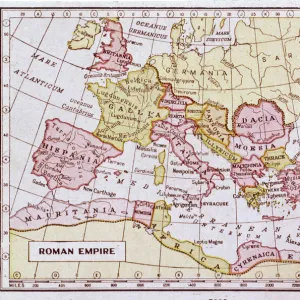
Jigsaw Puzzle : Roman empire map 1875


![]()
Jigsaw Puzzles From Fine Art Storehouse
Roman empire map 1875
The Independent Course Comprehensive Geography by James Monteith, A.S. Barnes & Co, New York & Chicago 1875
Unleash your creativity and transform your space into a visual masterpiece!
THEPALMER
Media ID 13612221
© This content is subject to copyright
Britannia Byzantine Egypt Empire Middle East Roman Rome Byzantium Dacia Drawing Art Product
Jigsaw Puzzle (1014 Pieces)
Discover the rich history of the Roman Empire with our captivating jigsaw puzzle from Media Storehouse, featuring the intricately detailed map 'Roman empire map 1875' by THEPALMER from Fine Art Storehouse. Originally published in James Monteith's The Independent Course in Comprehensive Geography by A.S. Barnes & Co, New York & Chicago in 1875, this historical puzzle invites you to piece together the vast territories and borders of the ancient Roman Empire. Immerse yourself in the past as you connect the lands and waterways, uncovering stories of power, conquest, and cultural influence. A perfect addition to any home or classroom, this challenging and rewarding puzzle is a must-have for history enthusiasts and puzzle lovers alike.
Made in the USA, 1014-piece puzzles measure 20" x 30" (50.8 x 76.2 cm). Every puzzle is meticulously printed on glossy photo paper, which has a strong 1.33 mm thickness. Delivered in a black storage cardboard box, these puzzles are both stylish and practical. (Note: puzzles contain small parts and are not suitable for children under 3 years of age.)
Jigsaw Puzzles are an ideal gift for any occasion
Estimated Product Size is 76cm x 50.8cm (29.9" x 20")
These are individually made so all sizes are approximate
Artwork printed orientated as per the preview above, with landscape (horizontal) orientation to match the source image.
FEATURES IN THESE COLLECTIONS
> Europe
> Spain
> Related Images
> North America
> United States of America
> New York
> Related Images
EDITORS COMMENTS
This print showcases a historical gem, the "Roman Empire Map 1875" taken from James Monteith's renowned work, "The Independent Course Comprehensive Geography". Published in New York and Chicago by A. S. Barnes & Co. , this exquisite piece of art takes us on a visual journey through the vast territories once ruled by the mighty Roman Empire. With meticulous detail and precision, this horizontal illustration beautifully captures Britannia, Byzantium, Dacia, Egypt, Spain, and other significant regions that were part of this ancient empire. The intricate etching and engraving techniques used to create this masterpiece add depth and texture to every stroke. As we gaze upon this remarkable drawing art product by THEPALMER from Fine Art Storehouse, we are transported back in time to an era filled with grandeur and power. The map not only serves as a geographical representation but also provides valuable insights into the political boundaries of that period. From the Middle East to USA's eastern coastlines lies evidence of Rome's influence on civilization. This artwork is a testament to their expansionist ambitions and enduring legacy. It reminds us of how nature shaped these landscapes while simultaneously being transformed by human hands. Whether you're an avid history enthusiast or simply appreciate fine craftsmanship, this Roman Empire Map 1875 print is sure to captivate your imagination and transport you back in time to one of history's most influential empires - truly a treasure for any art collector or lover of antiquity.
MADE IN THE USA
Safe Shipping with 30 Day Money Back Guarantee
FREE PERSONALISATION*
We are proud to offer a range of customisation features including Personalised Captions, Color Filters and Picture Zoom Tools
SECURE PAYMENTS
We happily accept a wide range of payment options so you can pay for the things you need in the way that is most convenient for you
* Options may vary by product and licensing agreement. Zoomed Pictures can be adjusted in the Basket.