Jigsaw Puzzle > Europe > Spain > Related Images
Jigsaw Puzzle : Political outline map of Europe


![]()
Jigsaw Puzzles From Fine Art Storehouse
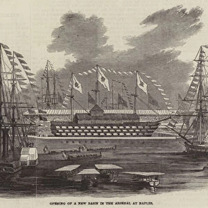
Political outline map of Europe
Political outline map of Europe from 1898
Unleash your creativity and transform your space into a visual masterpiece!
Nastasic
Media ID 13593125
© Nikola Nastasic
62990 Earth Globe Man Made Object Globe Navigational Equipment Portugal Portuguese Culture World Map Obsolete Retro Styled
Jigsaw Puzzle (520 Pieces)
"Discover the history and geography of Europe with our captivating jigsaw puzzle from the Media Storehouse collection. This intriguing puzzle features an authentic political outline map of Europe, inspired by the Fine Art Storehouse's timeless piece by Nastasic from 1898. Engage in a fun and educational experience as you piece together the intricate borders and territories of Europe's historic political landscape. Perfect for puzzle enthusiasts, history buffs, or anyone seeking a challenging and rewarding activity."
Made in the USA, 520-piece puzzles measure 16" x 20" (40.6 x 50.8 cm). Every puzzle is meticulously printed on glossy photo paper, which has a strong 1.33 mm thickness. Delivered in a black storage cardboard box, these puzzles are both stylish and practical. (Note: puzzles contain small parts and are not suitable for children under 3 years of age.)
Jigsaw Puzzles are an ideal gift for any occasion
Estimated Product Size is 50.8cm x 40.5cm (20" x 15.9")
These are individually made so all sizes are approximate
Artwork printed orientated as per the preview above, with landscape (horizontal) or portrait (vertical) orientation to match the source image.
FEATURES IN THESE COLLECTIONS
> Europe
> Italy
> Related Images
> Europe
> Spain
> Related Images
EDITORS COMMENTS
This print takes us back in time to the year 1898, presenting a political outline map of Europe. The retro-styled image showcases the intricate artistry of cartography from that era, with an antique and engraved aesthetic. A testament to its historical significance, this map is now considered obsolete but serves as a window into the past. The Portuguese culture shines through in this piece, reflecting their influence on navigation and exploration during that period. The detailed engraving highlights not only the physical geography of Europe but also includes neighboring countries such as Spain, Italy, Germany, France, and the United Kingdom. As we gaze upon this old-world charm captured by Nastasic's skilled illustration technique, we are reminded of how man-made objects like globes were once essential navigational tools for explorers and scholars alike. This horizontal composition invites us to explore every corner of Europe through its meticulously crafted lines and borders. While appreciating this artwork from Fine Art Storehouse, it is impossible not to marvel at how our understanding of the world has evolved since 1898. This print serves as a visual reminder of our ever-changing planet while honoring the rich history embedded within each stroke of Nastasic's work.
MADE IN THE USA
Safe Shipping with 30 Day Money Back Guarantee
FREE PERSONALISATION*
We are proud to offer a range of customisation features including Personalised Captions, Color Filters and Picture Zoom Tools
SECURE PAYMENTS
We happily accept a wide range of payment options so you can pay for the things you need in the way that is most convenient for you
* Options may vary by product and licensing agreement. Zoomed Pictures can be adjusted in the Basket.