Jigsaw Puzzle > Europe > United Kingdom > England > Plymouth
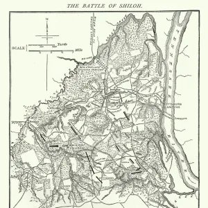
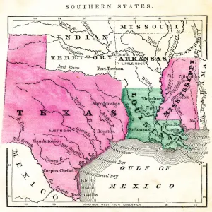
Jigsaw Puzzle : Map of Pamlico and Albemarle Sounds


![]()
Jigsaw Puzzles From Fine Art Storehouse
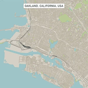
Map of Pamlico and Albemarle Sounds
Vintage engraving from 1863 of a map of Map of Pamlico and Albemarle Sounds at the time of the American Civil War
Unleash your creativity and transform your space into a visual masterpiece!
duncan1890
Media ID 13666639
© duncan1890
American Civil War American Culture Atlantic Ocean Chart Civil War Coastal Feature Document Eastern Usa Equipment Historical War Event Illustrations And Vector Art Information Equipment Land Land Feature Major Ocean Manufactured Object Massachusetts Mid Atlantic Usa Natural Phenomenon Navigational Equipment New England New England Usa North Carolina North Carolina Us State Objects Equipment Past Plan Printed Media Southern Usa Styles The Americas Traditional Culture Travel Locations Virginia Virginia Us State Image Created 19th Century Obsolete
Jigsaw Puzzle (1014 Pieces)
Discover the rich history of the American Civil War with our captivating jigsaw puzzle from Media Storehouse. Featuring a vintage engraving of the "Map of Pamlico and Albemarle Sounds" by duncan1890 from Fine Art Storehouse, this intriguing puzzle takes you back in time to 1863. Immerse yourself in the details of this beautifully preserved map, and enjoy the therapeutic process of piecing together history. A perfect addition to any home or classroom, this challenging yet rewarding puzzle is sure to provide hours of entertainment and education.
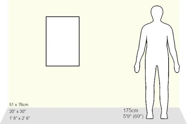
Made in the USA, 1014-piece puzzles measure 20" x 30" (50.8 x 76.2 cm). Every puzzle is meticulously printed on glossy photo paper, which has a strong 1.33 mm thickness. Delivered in a black storage cardboard box, these puzzles are both stylish and practical. (Note: puzzles contain small parts and are not suitable for children under 3 years of age.)
Jigsaw Puzzles are an ideal gift for any occasion
Estimated Product Size is 50.8cm x 76cm (20" x 29.9")
These are individually made so all sizes are approximate
Artwork printed orientated as per the preview above, with portrait (vertical) orientation to match the source image.
FEATURES IN THESE COLLECTIONS
> Fine Art Storehouse
> History
> Battles & Wars
> American Civil War (1860-1865)
> Fine Art Storehouse
> History
> Battles & Wars
> Historcal Battle Maps and Plans
> Fine Art Storehouse
> Map
> Historical Maps
> Fine Art Storehouse
> Map
> USA Maps
> USA Southern States Historical Maps
> Fine Art Storehouse
> Map
> USA Maps
> Arts
> Artists
> O
> Oceanic Oceanic
> Europe
> France
> Canton
> Landes
> Europe
> United Kingdom
> England
> Maps
> Europe
> United Kingdom
> England
> Plymouth
> Maps and Charts
> Early Maps
> Maps and Charts
> Related Images
> North America
> United States of America
> Maps
> North America
> United States of America
> Massachusetts
> Related Images
> North America
> United States of America
> North Carolina
> Related Images
EDITORS COMMENTS
This vintage engraving from 1863 showcases a captivating map of Pamlico and Albemarle Sounds during the tumultuous era of the American Civil War. With its intricate details and 19th-century style, this print offers a fascinating glimpse into the past. The image, created through an engraved woodcut technique, exudes an antique charm that transports us back to a time when cartography was both an art form and essential navigational equipment. The map encompasses the eastern coast of the United States, stretching from Plymouth, Massachusetts to Virginia in the Mid-Atlantic region. It highlights significant coastal features and land formations along with major bodies of water such as Pamlico Sound and Albemarle Sound which connect to the vast Atlantic Ocean. As we explore this historical document, we are reminded of how it served as a vital tool during one of America's most defining conflicts. Its presence evokes images of strategizing military leaders studying its lines and contours while planning their next moves on Southern soil. Beyond its practical use during war times, this print also represents American culture and traditional values deeply rooted in history. It symbolizes our fascination with exploration, travel locations, and preserving information through printed media. Duncan1890's expertly captured photograph immortalizes this remarkable piece of artistry for all to appreciate – reminding us that even in today's fast-paced world dominated by digital technology; there is still immense beauty found within objects crafted centuries ago.
MADE IN THE USA
Safe Shipping with 30 Day Money Back Guarantee
FREE PERSONALISATION*
We are proud to offer a range of customisation features including Personalised Captions, Color Filters and Picture Zoom Tools
SECURE PAYMENTS
We happily accept a wide range of payment options so you can pay for the things you need in the way that is most convenient for you
* Options may vary by product and licensing agreement. Zoomed Pictures can be adjusted in the Basket.