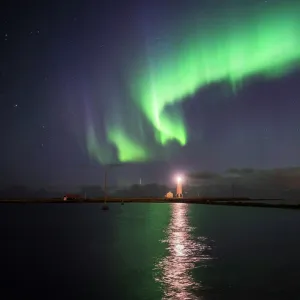
Jigsaw Puzzle > Europe > Iceland > Paintings
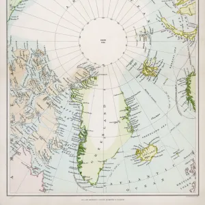
Jigsaw Puzzle : Map of Denmark, c.1900 (engraving)
")
")


![]()
Jigsaw Puzzles From Fine Art Finder
Map of Denmark, c.1900 (engraving)
532967 Map of Denmark, c.1900 (engraving); (add.info.: Map of Denmark, with insets of Iceland, Copenhagen, and the Faeroe Islands, circa 1902, from the 10th edition of Encyclopaedia Britannica.); Encyclopaedia Britannica/UIG
Media ID 38309832
© Encyclopaedia Britannica/UIG / Bridgeman Images
1902 19th Century Style Boundary Copenhagen Danish Denmark Geographical Border Guidance Iceland Illustration Technique Meridian Navigational Equipment Old Fashioned Physical Geography The Past Western Script
Jigsaw Puzzle (520 Pieces)
Discover the beauty of vintage cartography with our Map of Denmark jigsaw puzzle. Featuring intricate details and historical charm, this puzzle is perfect for history buffs and geography enthusiasts alike. Piece together a piece of Danish history with this captivating design from Fine Art Finder.
Made in the USA, 520-piece puzzles measure 16" x 20" (40.6 x 50.8 cm). Every puzzle is meticulously printed on glossy photo paper, which has a strong 1.33 mm thickness. Delivered in a black storage cardboard box, these puzzles are both stylish and practical. (Note: puzzles contain small parts and are not suitable for children under 3 years of age.)
Jigsaw Puzzles are an ideal gift for any occasion
Estimated Product Size is 50.8cm x 40.5cm (20" x 15.9")
These are individually made so all sizes are approximate
Artwork printed orientated as per the preview above, with landscape (horizontal) or portrait (vertical) orientation to match the source image.
FEATURES IN THESE COLLECTIONS
> Fine Art Finder
> Temp Classification
> Europe
> Denmark
> Copenhagen
> Europe
> Denmark
> Paintings
> Europe
> Denmark
> Related Images
> Europe
> Iceland
> Paintings
> Europe
> Iceland
> Related Images
EDITORS COMMENTS
This stunning engraving of a Map of Denmark, circa 1900, is a true masterpiece of cartography. The intricate details and precise lines showcase the artistry and skill that went into creating maps in the 19th century. With insets of Iceland, Copenhagen, and the Faeroe Islands, this map provides a comprehensive view of the region at that time.
The old-fashioned style of this map transports us back to an era of exploration and discovery. It serves as a reminder of how far we have come in terms of navigational equipment and geographical knowledge. The boundaries and coastlines are clearly defined, giving us a sense of the physical geography of Denmark.
As we gaze upon this historical artifact, we can't help but marvel at the craftsmanship involved in its creation. Each meridian and sea route is meticulously drawn with precision and care. This map was not just a tool for navigation but also a work of art in its own right.
Whether you are a history buff or simply appreciate fine illustration techniques, this Map of Denmark from c.1900 is sure to captivate your imagination. It offers a glimpse into the past while reminding us of the importance of understanding our world through maps and exploration.
MADE IN THE USA
Safe Shipping with 30 Day Money Back Guarantee
FREE PERSONALISATION*
We are proud to offer a range of customisation features including Personalised Captions, Color Filters and Picture Zoom Tools
SECURE PAYMENTS
We happily accept a wide range of payment options so you can pay for the things you need in the way that is most convenient for you
* Options may vary by product and licensing agreement. Zoomed Pictures can be adjusted in the Basket.