Fraud Blocker Skip to main content

Meridian Collection

"Exploring the Ancient Pathways: Unveiling the Meridians of Acupuncture" In Stanstead Abbotts

Background imageMeridian Collection: Stanstead Abbotts - The Bridge

Stanstead Abbotts - The Bridge
The village of Stanstead Abbott in Hertfordshire lies on the Greenwich Meridian. Date: 1907

Background imageMeridian Collection: Male dummy showing acupuncture meridians & points

Male dummy showing acupuncture meridians & points
Acupuncture dummy. Front view of a male acupuncture dummy showing meridians and acupuncture points. There are twelve main meridians (coloured lines)

Background imageMeridian Collection: Chinese acupuncture model

Chinese acupuncture model. Foot of a Chinese acupuncture model, with marking and numbers and labels to show the acupuncture points and lines (meridians)

Background imageMeridian Collection: Acupuncture

Acupuncture
ACUPUNCTURE The Meridian of the Large Intestine

Background imageMeridian Collection: Acupuncture

Acupuncture
ACUPUNCTURE The Meridian of the Heart

Background imageMeridian Collection: Acupuncture chart

Acupuncture chart

Background imageMeridian Collection: Caraway, Carum carvi

Caraway, Carum carvi
5856015 Caraway, Carum carvi; (add.info.: Caraway, Carum carvi. Chromolithograph from Carl Lindman's "Bilder ur Nordens Flora" (Pictures of Northern Flora), Stockholm

Background imageMeridian Collection: Map of Azores Islands, c.1900 (engraving)

Map of Azores Islands, c.1900 (engraving)
533297 Map of Azores Islands, c.1900 (engraving); (add.info.: Map of Azores Islands (Portuguese), circa 1900, from the 10th edition of Encyclopaedia Britannica.); Encyclopaedia Britannica/UIG.

Background imageMeridian Collection: Map of Italy, c.1900 (engraving)

Map of Italy, c.1900 (engraving)
532986 Map of Italy, c.1900 (engraving); (add.info.: Map of northern Italy, circa 1902, from the 10th edition of Encyclopaedia Britannica.); Encyclopaedia Britannica/UIG.

Background imageMeridian Collection: Map of Switzerland and Liechtenstein, c.1900 (engraving)

Map of Switzerland and Liechtenstein, c.1900 (engraving)
532974 Map of Switzerland and Liechtenstein, c.1900 (engraving); (add.info.: Map showing historical boundaries of Switzerland and Liechtenstein, circa 1902)

Background imageMeridian Collection: Map of England, c.1900 (engraving)

Map of England, c.1900 (engraving)
532917 Map of England, c.1900 (engraving); (add.info.: Map of England, with Oxford, Buckingham, Hertford, Essex, Middlesex, Berkshire, Hampshire, parts of Bedford and Wiltshire, circa 1902)

Background imageMeridian Collection: Map of North America and Central America, c.1900 (engraving)

Map of North America and Central America, c.1900 (engraving)
533069 Map of North America and Central America, c.1900 (engraving); (add.info.: Map of North America and Central America, circa 1902)

Background imageMeridian Collection: Map of Southern Africa, c.1900 (engraving)

Map of Southern Africa, c.1900 (engraving)
533065 Map of Southern Africa, c.1900 (engraving); (add.info.: Map of colonial southern Africa, with insets of Cape Town, Johannesburg, and Ladysmith, circa 1902)

Background imageMeridian Collection: Map of Trinidad and Martin Vas, c.1900 (engraving)

Map of Trinidad and Martin Vas, c.1900 (engraving)
533494 Map of Trinidad and Martin Vas, c.1900 (engraving); (add.info.: Map of Trinidad and Martin Vas, circa 1902, from the 10th edition of Encyclopaedia Britannica.); Encyclopaedia Britannica/UIG.

Background imageMeridian Collection: Map of Barbados, c.1900 (engraving)

Map of Barbados, c.1900 (engraving)
533469 Map of Barbados, c.1900 (engraving); (add.info.: Map showing the parish boundaries of Barbados, circa 1902, from the 10th edition of Encyclopaedia Britannica.); Encyclopaedia Britannica/UIG.

Background imageMeridian Collection: Map of the Bermudas, c.1900 (engraving)

Map of the Bermudas, c.1900 (engraving)
533466 Map of the Bermudas, c.1900 (engraving); (add.info.: Map of the Bermudas, circa 1902, from the 10th edition of Encyclopaedia Britannica.); Encyclopaedia Britannica/UIG.

Background imageMeridian Collection: Map of Saint Helena Island, c.1900 (engraving)

Map of Saint Helena Island, c.1900 (engraving)
533393 Map of Saint Helena Island, c.1900 (engraving); (add.info.: Map of Saint Helena Island, circa 1902, from the 10th edition of Encyclopaedia Britannica.); Encyclopaedia Britannica/UIG.

Background imageMeridian Collection: Map of Solomon Islands, c.1900 (engraving)

Map of Solomon Islands, c.1900 (engraving)
533372 Map of Solomon Islands, c.1900 (engraving); (add.info.: Map of Solomon Islands, Bougainville, South Pacific, circa 1902)

Background imageMeridian Collection: Map of islands in the South Pacific, c.1900 (engraving)

Map of islands in the South Pacific, c.1900 (engraving)
533367 Map of islands in the South Pacific, c.1900 (engraving); (add.info.: Map of New Hebrides Islands, Santa Cruz Islands, Loyalty Islands, and New Caledonia, circa 1902)

Background imageMeridian Collection: Map of Guam, c.1900 (engraving)

Map of Guam, c.1900 (engraving)
533357 Map of Guam, c.1900 (engraving); (add.info.: Map of Guam or Guajan Island (U.S.), circa 1902, from the 10th edition of Encyclopaedia Britannica.); Encyclopaedia Britannica/UIG.

Background imageMeridian Collection: Map of the north extension of Kurile Islands, c.1900 (engraving)

Map of the north extension of Kurile Islands, c.1900 (engraving)
533332 Map of the north extension of Kurile Islands, c.1900 (engraving); (add.info.: Map of the north extension of Kurile Islands (then part of Japan), circa 1902

Background imageMeridian Collection: Map of Sicily, c.1900 (engraving)

Map of Sicily, c.1900 (engraving)
533317 Map of Sicily, c.1900 (engraving); (add.info.: Map of Sicily, Italy, circa 1902, from the 10th edition of Encyclopaedia Britannica.); Encyclopaedia Britannica/UIG.

Background imageMeridian Collection: Map of East India Islands with New Guinea, c.1900 (engraving)

Map of East India Islands with New Guinea, c.1900 (engraving)
533036 Map of East India Islands with New Guinea, c.1900 (engraving); (add.info.: Map of East India Islands, with an inset of New Guinea, circa 1902)

Background imageMeridian Collection: Map of China, c.1900 (engraving)

Map of China, c.1900 (engraving)
533028 Map of China, c.1900 (engraving); (add.info.: Map of China, circa 1902, from the 10th edition of Encyclopaedia Britannica.); Encyclopaedia Britannica/UIG.

Background imageMeridian Collection: Map of Arabia with part of Turkey and Oman, c.1900 (engraving)

Map of Arabia with part of Turkey and Oman, c.1900 (engraving)
533009 Map of Arabia with part of Turkey and Oman, c.1900 (engraving); (add.info.: Map of Arabia, Turkey, Oman, Aden, with insets map of Jerusalem and Palestine, circa 1902)

Background imageMeridian Collection: Map of Turkey, c.1900 (engraving)

Map of Turkey, c.1900 (engraving)
533006 Map of Turkey, c.1900 (engraving); (add.info.: Map showing the historical boundaries of Turkey in Asia, circa 1902)

Background imageMeridian Collection: Map of Russia with inset of St. Petersburg, c.1900 (engraving)

Map of Russia with inset of St. Petersburg, c.1900 (engraving)
532995 Map of Russia with inset of St. Petersburg, c.1900 (engraving); (add.info.: Map of Russia, with an inset of St. Petersburg, circa 1902)

Background imageMeridian Collection: Map of Channel Islands, c.1900 (engraving)

Map of Channel Islands, c.1900 (engraving)
533278 Map of Channel Islands, c.1900 (engraving); (add.info.: Map of Channel Islands, United Kingdom, circa 1902, from the 10th edition of Encyclopaedia Britannica.); Encyclopaedia Britannica/UIG.

Background imageMeridian Collection: Map of Mexico, c.1900 (engraving)

Map of Mexico, c.1900 (engraving)
533250 Map of Mexico, c.1900 (engraving); (add.info.: Map of Mexico, circa 1902, from the 10th edition of Encyclopaedia Britannica.); Encyclopaedia Britannica/UIG.

Background imageMeridian Collection: Map of Peking, c.1900 (engraving)

Map of Peking, c.1900 (engraving)
532822 Map of Peking, c.1900 (engraving); (add.info.: Map of Peking (Beijing), China, circa 1900, from the 10th edition of Encyclopaedia Britannica.); Encyclopaedia Britannica/UIG.

Background imageMeridian Collection: Map of Milwaukee, c.1900 (engraving)

Map of Milwaukee, c.1900 (engraving)
532798 Map of Milwaukee, c.1900 (engraving); (add.info.: Map of Milwaukee, Wisconsin, circa 1900, from the 10th edition of Encyclopaedia Britannica.); Encyclopaedia Britannica/UIG.

Background imageMeridian Collection: USA History: A station in the meadow: the hundredth meridian

USA History: A station in the meadow: the hundredth meridian
5313532 USA History: A station in the meadow: the hundredth meridian.; SeM Studio/UIG.

Background imageMeridian Collection: Map of Japan and Korea, c.1900 (engraving)

Map of Japan and Korea, c.1900 (engraving)
533031 Map of Japan and Korea, c.1900 (engraving); (add.info.: Map of Japan and Korea, with insets of Kurile Islands, Liu-Kiu Islands and Formosa, circa 1902)

Background imageMeridian Collection: Map of southern India with Bombay, c.1900 (engraving)

Map of southern India with Bombay, c.1900 (engraving)
533019 Map of southern India with Bombay, c.1900 (engraving); (add.info.: Map showing historical boundaries of Southern India with inset map of Bombay (now Mumbai) and the Malay Peninsula

Background imageMeridian Collection: Map of Italy, c.1900 (engraving)

Map of Italy, c.1900 (engraving)
532983 Map of Italy, c.1900 (engraving); (add.info.: Map of Italy, with insets of Rome and Venice, circa 1902, from the 10th edition of Encyclopaedia Britannica.); Encyclopaedia Britannica/UIG.

Background imageMeridian Collection: Map of the Empire of Austria-Hungary, c.1900 (engraving)

Map of the Empire of Austria-Hungary, c.1900 (engraving)
532977 Map of the Empire of Austria-Hungary, c.1900 (engraving); (add.info.: Map of Empire of Austria-Hungary and inset of Budapest and Vicinity, circa 1902)

Background imageMeridian Collection: Map of Netherlands and Belgium, c.1900 (engraving)

Map of Netherlands and Belgium, c.1900 (engraving)
532956 Map of Netherlands and Belgium, c.1900 (engraving); (add.info.: Map showing the historical boundaries of Netherlands, Belgium, Luxemburg, with insets of Amsterdam and Brussels, circa 1902)

Background imageMeridian Collection: Map of Spain with Portugal and Andorra, c.1900 (engraving)

Map of Spain with Portugal and Andorra, c.1900 (engraving)
532952 Map of Spain with Portugal and Andorra, c.1900 (engraving); (add.info.: Map of Spain with Portugal and Andorra, with insets of the Azores Islands, Canary Islands, and Madeira Island)

Background imageMeridian Collection: Map of France, c.1900 (engraving)

Map of France, c.1900 (engraving)
532942 Map of France, c.1900 (engraving); (add.info.: Map of northern France with insets showing the provinces of France and Paris and Vicinity, circa 1902)

Background imageMeridian Collection: Map of England and Wales, c.1900 (engraving)

Map of England and Wales, c.1900 (engraving)
532924 Map of England and Wales, c.1900 (engraving); (add.info.: Map of England and Wales, with Hereford, Monmouth, Gloucester, Somerset, and parts of Worchester and Wiltshire, circa 1902)

Background imageMeridian Collection: Map of London, England, c.1900 (engraving)

Map of London, England, c.1900 (engraving)
532921 Map of London, England, c.1900 (engraving); (add.info.: Map of London, England, and vicinity, circa 1902, from the 10th edition of Encyclopaedia Britannica.); Encyclopaedia Britannica/UIG.

Background imageMeridian Collection: Map of England and Wales, c.1900 (engraving)

Map of England and Wales, c.1900 (engraving)
532903 Map of England and Wales, c.1900 (engraving); (add.info.: Map showing the historical boundaries of northern England and Wales, including insets of Liverpool, Manchester and Vicinity)

Background imageMeridian Collection: Map of Iceland, c.1900 (engraving)

Map of Iceland, c.1900 (engraving)
533307 Map of Iceland, c.1900 (engraving); (add.info.: Map of Iceland showing glaciers (Jokull), fjords and other geographical features, circa 1902

Background imageMeridian Collection: Map of South America, c.1900 (engraving)

Map of South America, c.1900 (engraving)
533256 Map of South America, c.1900 (engraving); (add.info.: Map of South America with inset maps of Isthmus of Panama, Galapagos Islands and Trinidad, circa 1902)

Background imageMeridian Collection: Map of Melbourne, c.1900 (engraving)

Map of Melbourne, c.1900 (engraving)
532791 Map of Melbourne, c.1900 (engraving); (add.info.: Map of Melbourne, Australia, circa 1900, from the 10th edition of Encyclopaedia Britannica.); Encyclopaedia Britannica/UIG.

Background imageMeridian Collection: Map of the colonial powers, 1902, c.1900 (engraving)

Map of the colonial powers, 1902, c.1900 (engraving)
532894 Map of the colonial powers, 1902, c.1900 (engraving); (add.info.: Map of the world showing "the Chief Countries and their Colonies," circa 1902)

Background imageMeridian Collection: Map of Canada, c.1900 (engraving)

Map of Canada, c.1900 (engraving)
533072 Map of Canada, c.1900 (engraving); (add.info.: Map showing historical boundaries of Canada and Newfoundland, circa 1902)

Background imageMeridian Collection: Map of colonial Africa, c.1900 (engraving)

Map of colonial Africa, c.1900 (engraving)
533053 Map of colonial Africa, c.1900 (engraving); (add.info.: Map of colonial Africa, with insets of Ascension Island, St)


All Professionally Made to Order for Quick Shipping

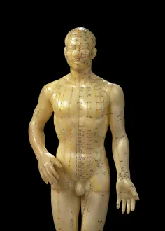
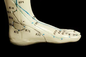
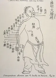
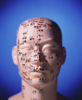
"Exploring the Ancient Pathways: Unveiling the Meridians of Acupuncture" In Stanstead Abbotts, a fascinating sight awaits as a male dummy showcases acupuncture meridians and points. The Bridge becomes a gateway to understanding this ancient healing art. A Chinese acupuncture model stands tall, embodying centuries of wisdom and knowledge. Its intricate design reveals the interconnectedness of our bodies' energy pathways. Acupuncture, an age-old practice rooted in traditional Chinese medicine, finds its place in modern times. As needles delicately pierce through specific points along these meridians, balance is sought within. An acupuncture chart serves as a guide on this journey towards holistic well-being. It maps out the body's energetic network with precision and clarity, offering insights into potential imbalances that can be addressed through treatment. Even on a cast of a head and neck, an acupuncture chart leaves no stone unturned. Every inch is meticulously studied to identify areas where harmony may have been disrupted. The Chinese acupuncture model reappears once more – an embodiment of timeless wisdom passed down through generations. It reminds us that our bodies are intricately connected systems deserving attention and care. As we delve deeper into this ancient practice, we realize its relevance transcends borders. Just like how Earth revolves around Africa and Europe in 3D rendering imagery; so too does the concept of meridians weave throughout cultures worldwide. Amidst all these captivating visuals lies another unexpected element - Douglas TA-4J Skyhawk 158520 aircraft. A reminder that even amidst technological advancements, there remains value in exploring alternative approaches to health and wellness. So let us embark on this enlightening journey together - unraveling the mysteries held within our own bodies' energetic pathways known as meridians.