Jigsaw Puzzle > North America > Cuba > Cuba Heritage Sites > Old Havana and its Fortification System
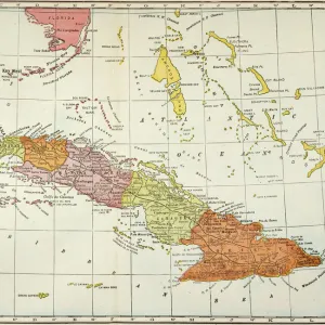
Jigsaw Puzzle : Geography Atlas: representation of the Caribbean Sea region, the Caribbean (Cuba, Jamaica, Hispaniola, Jamaica), the Bahamas Islands, the Lesser Antilles, the northern coasts of South America and the southern coasts of the United States
, the Bahamas Islands, the Lesser Antilles, the northern coasts of South America and the southern coasts of the United States")
, the Bahamas Islands, the Lesser Antilles, the northern coasts of South America and the southern coasts of the United States")


![]()
Jigsaw Puzzles From Fine Art Finder
Geography Atlas: representation of the Caribbean Sea region, the Caribbean (Cuba, Jamaica, Hispaniola, Jamaica), the Bahamas Islands, the Lesser Antilles, the northern coasts of South America and the southern coasts of the United States
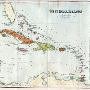
VEN5030043 Geography Atlas: representation of the Caribbean Sea region, the Caribbean (Cuba, Jamaica, Hispaniola, Jamaica), the Bahamas Islands, the Lesser Antilles, the northern coasts of South America and the southern coasts of the United States. Map from an Atlas by John Cary (1754-1835), 1803. Biblioteca Jose Marti, Havana, Cuba.; (add.info.: Geography Atlas: representation of the Caribbean Sea region, the Caribbean (Cuba, Jamaica, Hispaniola, Jamaica), the Bahamas Islands, the Lesser Antilles, the northern coasts of South America and the southern coasts of the United States. Map from an Atlas by John Cary (1754-1835), 1803. Biblioteca Jose Marti, Havana, Cuba.); © Marage Photos
Media ID 38478618
© © Marage Photos / Bridgeman Images
Amerique Centrale Amerique Du Nord Caraïbes Caribbean Caribbean Island Carte Geographique Central America Cuba Cuba Cubain Cubaine Cubains Cubaines Cuban Etats Unis Geographie Jamaica Jamaican Stockravenna Geographical Map
Jigsaw Puzzle (520 Pieces)
Explore the beauty and diversity of the Caribbean with our stunning jigsaw puzzle featuring a detailed map of the region. Perfect for geography enthusiasts and puzzle lovers alike, this captivating image from Bridgeman Images will provide hours of entertainment and challenge. Dive into the vibrant colors and intricate details of this unique piece of art as you piece together each section to reveal a breathtaking representation of the Caribbean Sea region.
Made in the USA, 520-piece puzzles measure 16" x 20" (40.6 x 50.8 cm). Every puzzle is meticulously printed on glossy photo paper, which has a strong 1.33 mm thickness. Delivered in a black storage cardboard box, these puzzles are both stylish and practical. (Note: puzzles contain small parts and are not suitable for children under 3 years of age.)
Jigsaw Puzzles are an ideal gift for any occasion
Estimated Product Size is 50.8cm x 40.5cm (20" x 15.9")
These are individually made so all sizes are approximate
Artwork printed orientated as per the preview above, with landscape (horizontal) or portrait (vertical) orientation to match the source image.
FEATURES IN THESE COLLECTIONS
> Maps and Charts
> Early Maps
> Maps and Charts
> Related Images
> North America
> The Bahamas
> Maps
> North America
> The Bahamas
> Related Images
> North America
> Cuba
> Cuba Heritage Sites
> Old Havana and its Fortification System
> North America
> Cuba
> Havana
> North America
> Cuba
> Maps
> North America
> Cuba
> Related Images
> North America
> Jamaica
> Maps
EDITORS COMMENTS
This stunning print from the Geography Atlas showcases the intricate details of the Caribbean Sea region, including Cuba, Jamaica, Hispaniola, and the Bahamas Islands. Created by John Cary in 1803, this map offers a glimpse into the geographical landscape of the area during that time period.
The representation of the Lesser Antilles and the northern coasts of South America adds to the richness of this historical piece. The southern coasts of the United States are also included in this comprehensive atlas, providing a holistic view of these interconnected regions.
Displayed at Biblioteca Jose Marti in Havana, Cuba, this map serves as a valuable resource for understanding the complex geography and topography of Central America and North America during the 19th century. The detailed engravings capture not only physical features but also cultural nuances that define each location.
As you study this print closely, you can appreciate how it reflects centuries-old cartographic techniques and artistic craftsmanship. Whether you're a history buff or simply intrigued by maps, this Geography Atlas print is sure to captivate your imagination with its wealth of information about these diverse landscapes.
MADE IN THE USA
Safe Shipping with 30 Day Money Back Guarantee
FREE PERSONALISATION*
We are proud to offer a range of customisation features including Personalised Captions, Color Filters and Picture Zoom Tools
SECURE PAYMENTS
We happily accept a wide range of payment options so you can pay for the things you need in the way that is most convenient for you
* Options may vary by product and licensing agreement. Zoomed Pictures can be adjusted in the Basket.