Jigsaw Puzzle > Europe > United Kingdom > England > London > Museums > National Maritime Museum
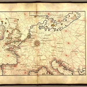
Jigsaw Puzzle : Map of Creta 1554, 1554 (vellum)
")
")


![]()
Jigsaw Puzzles From Fine Art Finder
Map of Creta 1554, 1554 (vellum)
7339647 Map of Creta 1554, 1554 (vellum) by Agnese, Battista (c.1500-64); 26x40 cm; National Maritime Museum, London, UK; (add.info.: Creator: Battista Agnese
Bound sheet. Scale: [circa 1:3 000 000]. Cartographic Note: North at 180 degrees. Additional Places: Crete. Contents Note: Iconography: towns and cities; one ship (galley). Bound in an atlas of twenty-four cartographic items titled: Seekarten von Battista Agnese Anno MDLIV.d.IV.May. The atlas also includes astronomical tables and diagrams. Text in Latin, titles and place names in German outside borders.); © National Maritime Museum, Greenwich, London
Media ID 38509990
© © National Maritime Museum, Greenwich, London / Bridgeman Images
Creta Crete Krete C16h Geographer Greece Greek
Jigsaw Puzzle (1014 Pieces)
Embark on a journey through history with our captivating Map of Creta 1554 jigsaw puzzle, featuring intricate details and vibrant colors. Perfect for art enthusiasts and history buffs alike!
Made in the USA, 1014-piece puzzles measure 20" x 30" (50.8 x 76.2 cm). Every puzzle is meticulously printed on glossy photo paper, which has a strong 1.33 mm thickness. Delivered in a black storage cardboard box, these puzzles are both stylish and practical. (Note: puzzles contain small parts and are not suitable for children under 3 years of age.)
Jigsaw Puzzles are an ideal gift for any occasion
Estimated Product Size is 76cm x 50.8cm (29.9" x 20")
These are individually made so all sizes are approximate
Artwork printed orientated as per the preview above, with landscape (horizontal) orientation to match the source image.
FEATURES IN THESE COLLECTIONS
> Fine Art Finder
> Artists
> Battista Agnese
> Arts
> Artists
> A
> Battista Agnese
> Europe
> Greece
> Related Images
> Europe
> United Kingdom
> England
> London
> Boroughs
> Greenwich
> Europe
> United Kingdom
> England
> London
> Museums
> Greenwich Heritage Centre
> Europe
> United Kingdom
> England
> London
> Museums
> National Maritime Museum
> Europe
> United Kingdom
> England
> London
> Towns
> Greenwich
EDITORS COMMENTS
This stunning print captures the intricate details of a Map of Creta from 1554, created by Battista Agnese. The map, measuring 26x40 cm, is displayed on vellum and showcases the island of Crete in all its glory.
Battista Agnese's meticulous craftsmanship is evident in this cartographic masterpiece, with towns and cities meticulously depicted along with a single ship sailing through the waters. The scale of the map is approximately 1:3,000,000 with North oriented at 180 degrees.
Bound within an atlas containing twenty-four cartographic items titled 'Seekarten von Battista Agnese Anno MDLIV.d.IV.May,' this piece also includes astronomical tables and diagrams. Text in Latin accompanies titles and place names in German outside the borders.
The vibrant colors used to bring this map to life add depth and dimension to the historical representation of Crete during the sixteenth century. This work of art not only serves as a geographical reference but also stands as a testament to Agnese's skill as a geographer and artist.
Displayed at the National Maritime Museum in London, UK, this print allows viewers to appreciate the beauty and complexity of cartography from centuries past.
MADE IN THE USA
Safe Shipping with 30 Day Money Back Guarantee
FREE PERSONALISATION*
We are proud to offer a range of customisation features including Personalised Captions, Color Filters and Picture Zoom Tools
SECURE PAYMENTS
We happily accept a wide range of payment options so you can pay for the things you need in the way that is most convenient for you
* Options may vary by product and licensing agreement. Zoomed Pictures can be adjusted in the Basket.