Home > Maps and Charts > Americas
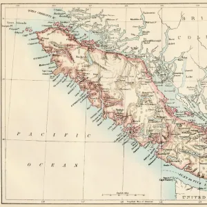
The route of the Alaska excursion steamers, 1891. Creator: Charles Sumner Fee

![]()
Wall Art and Photo Gifts from Heritage Images
The route of the Alaska excursion steamers, 1891. Creator: Charles Sumner Fee
The route of the Alaska excursion steamers, 1891. This map, published in 1891, shows the excursion steamship routes from Seattle, which took the inland waterway east of Vancouver Island and on to Alaska, as well as the interconnecting railroad routes from Chicago on the Great Northern and Northern Pacific Lines. Includes ancillary maps of the Northwestern States and Alaska
Heritage Images features heritage image collections
Media ID 35127757
© Heritage Art/Heritage Images
Alaska United States Of America Cartographic Cartography Excursion Great Northern Railway Map Making Mapmaking North America North American Railroad Railways Route Steam Boat Steam Ship Steamboat Steamer Boat Steamship Waterway Waterways Meeting Of Frontiers Northern Pacific Railway
FEATURES IN THESE COLLECTIONS
> Maps and Charts
> Early Maps
> North America
> Canada
> Maps
> North America
> Canada
> Related Images
> North America
> Canada
> Vancouver
> North America
> United States of America
> Alaska
> Related Images
> North America
> United States of America
> Illinois
> Chicago
> North America
> United States of America
> Illinois
> Related Images
> North America
> United States of America
> Maps
> North America
> United States of America
> Washington
> Related Images
EDITORS COMMENTS
This map, titled "The route of the Alaska excursion steamers, 1891," is an intriguing glimpse into the past of American travel and transportation during the late 19th century. Created by Charles Sumner Fee and published in 1891, this map offers a detailed representation of the excursion steamship routes from Seattle that traversed the inland waterway east of Vancouver Island and continued on to Alaska. The map also illustrates the interconnecting railroad routes from Chicago on the Great Northern and Northern Pacific Lines. The map serves as a testament to the meeting of frontiers during this era, as it connects the Northwestern States of the United States with Alaska. The North American landscape comes alive in vibrant colors and intricate detail, with ancillary maps of the Northwestern States and Alaska adding depth to the overall composition. Charles Sumner Fee's masterful cartographic skills are on full display in this map, which showcases the steamship routes that played a significant role in the transportation of people and goods between the United States and Alaska during this period. The map's historical significance lies in its ability to transport us back to a time when the spirit of exploration and adventure was at its peak. The map's rich heritage art style, reminiscent of the 19th century, is a feast for the eyes, with its intricate details and accurate depictions of the North American landscape. The map is a valuable addition to any collection of historical maps or Americana, and a must-have for anyone interested in the history of travel, transportation, or the United States during the late 1800s.
MADE IN THE USA
Safe Shipping with 30 Day Money Back Guarantee
FREE PERSONALISATION*
We are proud to offer a range of customisation features including Personalised Captions, Color Filters and Picture Zoom Tools
SECURE PAYMENTS
We happily accept a wide range of payment options so you can pay for the things you need in the way that is most convenient for you
* Options may vary by product and licensing agreement. Zoomed Pictures can be adjusted in the Cart.