Home > Europe > United Kingdom > England > London > Transport > Railway
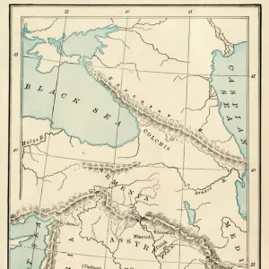
Map of Syria, 1851. Artist: John Tallis

![]()
Wall Art and Photo Gifts from Heritage Images
Map of Syria, 1851. Artist: John Tallis
Map of Syria, 1851. From The Illustrated Atlas, And Modern History Of The World Geographical, Political, Commercial & Statistical edited by R. Montgomery Martin, Esq. [J & F. Tallis, London, Edinburgh & Dublin, 1851]
Heritage Images features heritage image collections
Media ID 14978272
© The Print Collector
Atlas Border Boundary Camel Camel Train Camels Cartography Hillside Map Making Martin Syria Tallis John Tallis
FEATURES IN THESE COLLECTIONS
> Arts
> Artists
> T
> John Tallis
> Europe
> United Kingdom
> England
> London
> Transport
> Railway
> Europe
> United Kingdom
> Scotland
> Edinburgh
> Edinburgh
> Europe
> United Kingdom
> Scotland
> Lothian
> Edinburgh
> Europe
> United Kingdom
> Wales
> Powys
> Montgomery
EDITORS COMMENTS
This print, titled "Map of Syria, 1851" takes us back to the enchanting world of cartography in the 19th century. Created by the talented artist John Tallis, this illustration was featured in The Illustrated Atlas, And Modern History Of The World Geographical, Political, Commercial & Statistical edited by R. Montgomery Martin. The intricate details of this map transport us to a time when transportation relied heavily on animals and nature's terrain. A close-up view reveals a hillside landscape dotted with people and animals alike. Among them are majestic camels forming a camel train, symbolizing the vital role they played in Syrian trade routes during that era. As we explore further into this monochrome masterpiece, we discover political boundaries meticulously depicted through precise engraving techniques. This historical publication serves as an invaluable resource for understanding Syria's geographical layout and its place within global politics at that time. The print collector who preserved this artwork has allowed us to glimpse into an era where map-making was both an art form and a scientific endeavor. Through John Tallis' skillful craftsmanship and R. Montgomery Martin's editorial vision, this illustrated atlas continues to captivate modern audiences seeking insight into our rich historical past.
MADE IN THE USA
Safe Shipping with 30 Day Money Back Guarantee
FREE PERSONALISATION*
We are proud to offer a range of customisation features including Personalised Captions, Color Filters and Picture Zoom Tools
SECURE PAYMENTS
We happily accept a wide range of payment options so you can pay for the things you need in the way that is most convenient for you
* Options may vary by product and licensing agreement. Zoomed Pictures can be adjusted in the Cart.