Home > North America > United States of America > Mississippi > Jackson
Map showing the lands assigned to emigrant Indians west of Arkansas and Missouri, 1836. Creator: Topographical Bureau

![]()
Wall Art and Photo Gifts from Heritage Images
Map showing the lands assigned to emigrant Indians west of Arkansas and Missouri, 1836. Creator: Topographical Bureau
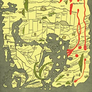
Map showing the lands assigned to emigrant Indians west of Arkansas and Missouri, 1836. Following passage of the Indian Removal Act in 1830, President Andrew Jackson implemented a policy of land exchanges and forced expulsion of the eastern Native Americans to regions west of the Mississippi River. It shows the approximate boundaries of the lands assigned to the relocated tribes in territories west of the Mississippi by 1836. Different shades of color are used to indicate the various tribes. The map also shows the southwestern border of the United States with Mexico, which at that time included the territory that was soon to become the independent Republic of Texas. Forced cession of land by tribes indigenous to the American West, such as the Sioux, is also shown. Approximate geographical boundaries are indicated by rivers, trails, and forts, as territories and states had yet to form in this area. The number of Indians who "emigrated" is listed in the lower right margin, as well as the number of "resident" Indians already living in these regions and the number of Indian tribes remaining east of the Mississippi. Included as well is the total acreage of lands granted by the federal government to the new immigrants according to each tribe
Heritage Images features heritage image collections
Media ID 35130315
© Heritage Art/Heritage Images
1830s Arkansas Boundary Cartographic Cartography Cherokee Choctaw Creek Delaware Emigrant Expulsion Immigrant Immigration Indians Land Map Making Mapmaking Mississippi Mississippi River Missouri North America North American Omaha Osage Otoe Ottoe Pawnee Pawnees Plains Indian Ponca Removal River Mississippi Sac And Fox Sauk And Fox Shawano Shawnee Sioux Territorial Territory Tribe Ioway Kansa Meeting Of Frontiers Tribes
FEATURES IN THESE COLLECTIONS
> Animals
> Mammals
> Muridae
> Plains Mouse
> Asia
> East Timor
> Maps
> Asia
> East Timor
> Related Images
> Maps and Charts
> Early Maps
> North America
> Mexico
> Related Images
> North America
> United States of America
> Arkansas
> Related Images
> North America
> United States of America
> Delaware
> Related Images
> North America
> United States of America
> Maps
> North America
> United States of America
> Mississippi
> Jackson
EDITORS COMMENTS
This historic print captures a significant moment in American history, depicting a map showing the lands assigned to emigrant Indians west of Arkansas and Missouri in 1836. The creation of this map was prompted by the Indian Removal Act of 1830, which was implemented by President Andrew Jackson. This policy aimed to forcefully relocate Native Americans from their ancestral lands east of the Mississippi River to territories further west.
The map showcases the approximate boundaries designated for relocated tribes, using different shades of color to represent each tribe. It also highlights the southwestern border of the United States with Mexico, including territory that would soon become Texas. Additionally, it reveals forced cessions of land by indigenous tribes such as the Sioux.
Geographical features like rivers, trails, and forts are used to indicate approximate boundaries since states and territories had yet to be formed in this area at that time. In the lower right margin, important details are listed: the number of Indians who "emigrated," along with those already residing in these regions and remaining east of the Mississippi River. Furthermore, it includes information on total acreage granted by the federal government according to each tribe.
This print serves as a valuable historical document shedding light on America's complex relationship with its indigenous peoples during this period marked by forced relocation and land exchanges. It is an important reminder of our nation's past actions towards Native Americans and provides insight into how tribal lands were allocated during this tumultuous era.
MADE IN THE USA
Safe Shipping with 30 Day Money Back Guarantee
FREE PERSONALISATION*
We are proud to offer a range of customisation features including Personalised Captions, Color Filters and Picture Zoom Tools
SECURE PAYMENTS
We happily accept a wide range of payment options so you can pay for the things you need in the way that is most convenient for you
* Options may vary by product and licensing agreement. Zoomed Pictures can be adjusted in the Cart.