sudo bash cd /www/dmc Map illustrating the Closing Phases of the East African Skip to main content

Home > Africa > Democratic Republic of the Congo > Lakes > Related Images

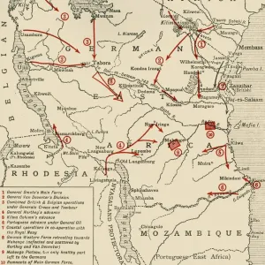
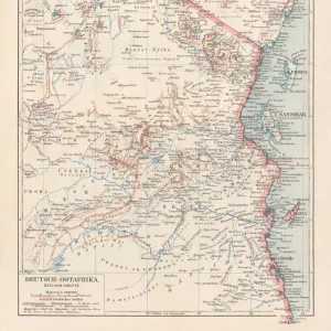
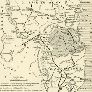
Map illustrating the Closing Phases of the East African Campaign, 1917-18, (c1920)

Map illustrating the Closing Phases of the East African Campaign, 1917-18, (c1920)
In Stock
We accept all major payment options so you can pay for the things you need in the way that is most convenient for you

Choose Your Product

Framed Photos
Buy from $79.99
Photo Prints
Buy from $9.99
Jigsaw Puzzles
Buy from $39.99
Poster Prints
Buy from $24.99
Canvas Prints
Buy from $99.99
Fine Art Prints
Buy from $60.90
Metal Prints
Buy from $169.99
Home Decor
Buy from $16.99

Heritage Images Photo Prints and Wall Art

Map illustrating the Closing Phases of the East African Campaign, 1917-18, (c1920)

Map illustrating the Closing Phases of the East African Campaign, 1917-18, (c1920). European powers in Africa during the First World War: Shaded area showing Territory still held by the enemy in German East Africa at the beginning of 1917; Coastal areas held by British troops; General von Lettow-Vorbecks track from December 1916 to his surrender on November 14, 1918; Colonel Tafels line of retreat from the Mohenge district until his surrender on November 27, 1918; Track of the Wintgens-Naumann raiding force, February-October 1917. From " The Great World War: A History", Volume IX, edited by Frank A Mumby. [The Gresham Publishing Company Ltd, London, c1920]. Heritage Images features heritage image collections. © The Print Collector/Heritage Images

Media ID 19666065

Belgian Congo British East Africa Coastline Colonies Colony Congo East Africa East African Campaign Frank A Frank A Mumby Frank Arthur Frank Arthur Mumby Front Line Frontline German East Africa German East African Campaign Gresham Publishing Co Ltd Gresham Publishing Company Imperialism Indian Ocean Keystone Archives Lines Mozambique Mumby Mumby Frank A Mumby Frank Arthur Nyasaland Position Positions Rhodesia Rhodesia Africa The Great World War A History Theatre Of War Battlefield Lake Malawi Lake Nyasa

FEATURES IN THESE COLLECTIONS

> Africa > Democratic Republic of the Congo > Lakes > Related Images

> Africa > Malawi > Lakes > Lake Nyasa

> Africa > Malawi > Lakes > Related Images

> Africa > Malawi > Maps

> Africa > Malawi > Related Images

> Africa > Mozambique > Lakes > Lake Nyasa

> Africa > Mozambique > Lakes > Related Images

> Africa > Mozambique > Maps

> Africa > Mozambique > Related Images

> Africa > Related Images

SECURE PAYMENTS
We accept all major payment options so you can pay for the things you need in the way that is most convenient for you

Made in USA
Safe Shipping, Easy Returns

FREE PERSONALISATION
We are proud to offer a range of customisation including Cropping, Captions, and Filters. Zoom Cropping can be adjusted in the basket


EDITORS COMMENTS

This print showcases a detailed map illustrating the closing phases of the East African Campaign during 1917-18. The map, taken from "The Great World War: A History" provides a comprehensive overview of the European powers' presence in Africa during World War I. It highlights various significant locations and tracks related to this campaign. The shaded area represents the territory still held by the enemy in German East Africa at the beginning of 1917, while coastal areas are shown as being under British control. The map also traces General von Lettow-Vorbeck's track from December 1916 until his surrender on November 14,1918. Additionally, it depicts Colonel Tafel's line of retreat from the Mohenge district until his surrender on November 27,1918. Another notable feature is the track of the Wintgens-Naumann raiding force between February and October 1917. This image offers insights into key military movements and positions during this period. With its historical significance, this print serves as a valuable resource for understanding colonialism, imperialism, and warfare in early twentieth-century Africa. It sheds light on how European powers vied for control over territories such as German East Africa (present-day Tanzania) and their impact on local populations. Preserved by Heritage Images, this photograph captures an important chapter in world history that shaped not only Africa but also global geopolitics during that time.


Framed Prints of Map illustrating the Closing Phases of the East African Campaign, 1917-18, (c1920)

Step back in time with our vintage Framed Print from the Media Storehouse collection. This intriguing piece showcases an historic map illustrating the Closing Phases of the East African Campaign during the First World War, dating back to approximately 1920. The map provides a fascinating glimpse into European powers' territories in Africa during this era, offering a captivating display of historical geography. Add this unique and educational print to your home or office decor, and let the stories of the past unfold before your eyes.


Photo Prints of Map illustrating the Closing Phases of the East African Campaign, 1917-18, (c1920)

Step back in time with our vintage photographic print from the Media Storehouse collection. This captivating image, sourced from Heritage Images, depicts a map illustrating the closing phases of the East African Campaign during the First World War, circa 1920. European powers' territorial holdings in Africa are clearly marked, providing a unique insight into the geopolitical landscape of the time. Add this historical piece to your collection and bring a piece of the past into your home or office.


Poster Prints of Map illustrating the Closing Phases of the East African Campaign, 1917-18, (c1920)

Step back in time with our vintage Map Print from the Media Storehouse collection, showcasing the Closing Phases of the East African Campaign during the First World War (1917-18). This captivating illustration, sourced from Heritage Images and dated circa 1920, offers a unique perspective on European powers' territorial holdings in Africa. Add an air of historical intrigue to your space with this striking and authentic poster print.


Jigsaw Puzzles of Map illustrating the Closing Phases of the East African Campaign, 1917-18, (c1920)

Step back in time with our intricately detailed Jigsaw Puzzle from Media Storehouse, featuring a captivating map illustrating the Closing Phases of the East African Campaign during the First World War (1917-18). This vintage puzzle, sourced from Heritage Images, showcases the European powers' territories in Africa during this pivotal period in history. Engage your mind and immerse yourself in the rich tapestry of the past as you piece together this historical puzzle. A perfect addition to any home or office, this puzzle is not only a fun and engaging activity but also a beautiful conversation starter. Bring history to life with Media Storehouse Jigsaw Puzzles.

diamond
Made With High Grade Materials
thumb_up
Professional Quality Finish
package_2
Carefully Packed To Aid Safe Arrival

You May Also Like


Colonial possessions in East Africa during the First World War, c1916, (c1920). Creator: UnknownColonial possessions in East Africa during the First World War, c1916, (c1920). Creator: Unknown
Add to Basket
Manuel Almunia (Arsenal) celebrates saving Doncasters 2nd penalty during the penalty shoot outManuel Almunia (Arsenal) celebrates saving Doncasters 2nd penalty during the penalty shoot out
Add to Basket
The Pavilion at Wrest Park J020164The Pavilion at Wrest Park J020164
Add to Basket
Madame ButterflyMadame Butterfly
Add to Basket
Mozart & Aloysia WeberMozart & Aloysia Weber
Add to Basket
Canary Dog - also know as Perro de Presa Canario - 3 puppiesCanary Dog - also know as Perro de Presa Canario - 3 puppies
Add to Basket
Poodle a054086Poodle a054086
Add to Basket
Rhea Darwinii J970109Rhea Darwinii J970109
Add to Basket
Postcard from Charles Darwin to A R Wallace K960212Postcard from Charles Darwin to A R Wallace K960212
Add to Basket
Easter eggsEaster eggs
Add to Basket
Gnomes, Port Stanley, Falkland Islands, South AmericaGnomes, Port Stanley, Falkland Islands, South America
Add to Basket
Caledonian Canal, Inverness, 2007Caledonian Canal, Inverness, 2007
Add to Basket

Gallery Wall Inspiration

My Fair Lady, Adelphi Theatre, 1980 DD004008
Noel Gallagher Singer September 1998 Oasis band member talking to supermodel Kate
Holland House library after an air raid BB83_04456
Piccadilly Circus, LNER poster, 1923-1947
Programme design, Gilbert & Sullivan, Princess Ida
Retro poster, Gilbert & Sullivan, D Oyly Carte
The Dolly Sisters and Laddie Cliff in Jig-saw at Hippodrome
Edmund Kean as Sir Giles Overreach in A New Way to Pay Old Debts, c. 1816 (oil on canvas)
Supper Scene at the Savoy (colour litho)
Gilbert & Sullivan Operas, D Oyly Carte Souvenir
Southport, For a Holiday In Wintertime, LMS poster, 1925
Priscilla, Queen of the Desert musical
Ballet dancers Rudolf Nureyev and Margot Fonteyn rehearsing Marguerite
Beggars Opera Poster
Map of Cornwall from the Theatre of the Empire of Great Britain, pub
Four ballerinas on a music sheet
Globe Performance
Metropolitan Music Hall, Edgware Road
Sherlock Holmes theatre poster
The London Palladium
Battle of the Somme, First World War, July 1916, (c1920). Creator: Unknown
The Theatre-Zoo shop window DD003928
The Farce by William Barribal
Theatre Crowd in Shaftesbury Avenue, London
Elizabethan London
Portrait of Marie-Adeline Plunkett, 1854. Creator: Richard Buckner
Globe Theatre J060052

Discover Our Collections


Africa Related ImagesAfrica Related Images
View Collection
Malawi Related ImagesMalawi Related Images
View Collection
Mozambique Related ImagesMozambique Related Images
View Collection
MapsMaps
View Collection
MapsMaps
View Collection
Lakes Related ImagesLakes Related Images
View Collection
Lakes Related ImagesLakes Related Images
View Collection
Lake NyasaLake Nyasa
View Collection
Lakes Related ImagesLakes Related Images
View Collection
Lake NyasaLake Nyasa
View Collection


© Copyright Media Storehouse, All Rights Reserved 2003 - 2024
Facebook     Pinterest     100% Payment Secure     Reviews IO