Home > Europe > France > Canton > Nord
'Les oasis de Libye; Le Nord-Est Africain, 1914. Creator: Unknown

![]()
Wall Art and Photo Gifts from Heritage Images
'Les oasis de Libye; Le Nord-Est Africain, 1914. Creator: Unknown
'Les oasis de Libye; Le Nord-Est Africain, 1914. From "Grande Geographie Bong Illustree", 1914
Heritage Images features heritage image collections
Media ID 36296363
© The Print Collector/Heritage Images
Cartography Libya Map Making Mapmaking
FEATURES IN THESE COLLECTIONS
> Africa
> Libya
> Related Images
> Europe
> France
> Canton
> Nord
EDITORS COMMENTS
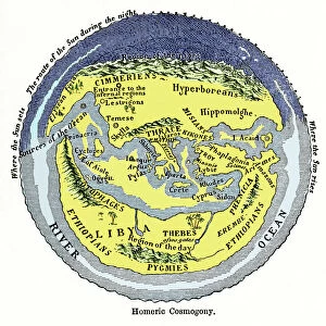
Les Oasis de Libye; Le Nord-Est Africain," translated to "The Oases of Libya; The Northeastern African Region," is a captivating and intriguing map print from the early 20th century. The map, created in 1914, is an exquisite example of cartography from the era, showcasing the Northeastern region of Africa, with a particular focus on Libya. The map is a vibrant and detailed representation of the geography of the region, with various shades of brown and beige, interspersed with patches of green, representing the vast expanses of the Sahara Desert and the lush oases scattered throughout. The map is adorned with annotations and labels in French, reflecting its origins in France during the height of European exploration and colonization. The map is a fascinating window into the past, providing insights into the geographical knowledge of the time, as well as the political and cultural context of the early 20th century. The map's title, "Les Oasis de Libye; Le Nord-Est Africain," highlights the focus on the oases, which were crucial sources of water and sustenance for travelers and settlers in the arid region. The map's creator remains unknown, but it was published in the renowned French geography magazine "Grande Geographie Bong Illustree" in 1914. The map's inclusion in the magazine underscores its significance as an important historical document, providing valuable information about the geography and exploration of a region that was still largely unknown to the Western world at the time. Today, this map is a precious addition to any collection of historical cartography or African studies, offering a glimpse into the past and the rich history of exploration and discovery that shaped our understanding of the world.
MADE IN THE USA
Safe Shipping with 30 Day Money Back Guarantee
FREE PERSONALISATION*
We are proud to offer a range of customisation features including Personalised Captions, Color Filters and Picture Zoom Tools
SECURE PAYMENTS
We happily accept a wide range of payment options so you can pay for the things you need in the way that is most convenient for you
* Options may vary by product and licensing agreement. Zoomed Pictures can be adjusted in the Cart.