Home > Arts > Photorealistic artworks > Detailed art pieces > Masterful detailing in art
General Map of Kursk Province: Showing Postal and Major Roads, Stations and the... 1822. Creators: Vasilii Petrovich Piadyshev, Ieremin

![]()
Wall Art and Photo Gifts from Heritage Images
General Map of Kursk Province: Showing Postal and Major Roads, Stations and the... 1822. Creators: Vasilii Petrovich Piadyshev, Ieremin
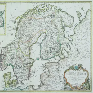
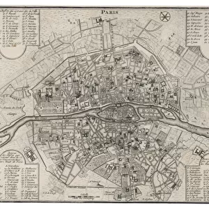
General Map of Kursk Province: Showing Postal and Major Roads, Stations and the Distance in Versts between Them, 1822. This 1822 map of Kursk Provinceis from a larger work, Geograficheskii atlas Rossiiskoi imperii, tsarstva Pol'skogo i velikogo kniazhestva Finliandskogo(Geographical atlas of the Russian Empire, the Kingdom of Poland, and the Grand Duchy of Finland), containing 60 maps of the Russian Empire. Compiled and engraved by Colonel V.P. Piadyshev, it reflects the detailed mapping carried out by Russian military cartographers in the first quarter of the 19th century. The map shows population centers (seven gradations by size), postal stations, roads (four types), provincial and district borders, forts, monasteries, and factories. Distances are shown in versts, a Russian measure, now no longer used, equal to 1.07 kilometers.Legends and place-names are in Russian and French
Heritage Images features heritage image collections
Media ID 35128981
© Heritage Art/Heritage Images
1820s Atlas Border Borders Cartographic Cartography Communication Cyrillic Factories Fort Forts Legend Legendary Map Making Mapmaking Military Topographical Depot Monasteries Monastery Piadyshev Vasilii Petrovich Postal Station Roads Russian Empire Russian Federation Thoroughfare Vasilii Petrovich Piadyshev Vp Piadyshev Fortifications Meeting Of Frontiers Postal Service
FEATURES IN THESE COLLECTIONS
> Arts
> Photorealistic artworks
> Detailed art pieces
> Masterful detailing in art
> Europe
> Finland
> Related Images
> Europe
> Poland
> Related Images
EDITORS COMMENTS
This historic map print, titled "General Map of Kursk Province: Showing Postal and Major Roads, Stations and the Distance in Versts between Them," dates back to 1822. It is an extract from the larger work, "Geograficheskii atlas Rossiiskoi imperii, tsarstva Pol'skogo i velikogo kniazhestva Finliandskogo" (Geographical atlas of the Russian Empire, the Kingdom of Poland, and the Grand Duchy of Finland), which consisted of 60 maps of the Russian Empire. The map was compiled and engraved by Colonel Vasilii Petrovich Piadyshev and Ieremin. The map provides an intricate depiction of Kursk Province during the early 19th century. It reflects the meticulous mapping efforts carried out by Russian military cartographers during this period. The map includes population centers, graded by size, postal stations, roads (with four distinct types), provincial and district borders, forts, monasteries, and factories. Distances are indicated in versts, a Russian measurement now obsolete, equivalent to approximately 1.07 kilometers. The map's legends and place-names are in both Russian and French, reflecting the multilingual nature of the Russian Empire during this time. This detailed and accurate representation of Kursk Province offers a fascinating glimpse into the geography and infrastructure of Russia during the early 19th century. The map's historical significance lies in its meticulous compilation and the extensive information it provides on the region's topography, transportation networks, and settlements.
MADE IN THE USA
Safe Shipping with 30 Day Money Back Guarantee
FREE PERSONALISATION*
We are proud to offer a range of customisation features including Personalised Captions, Color Filters and Picture Zoom Tools
SECURE PAYMENTS
We happily accept a wide range of payment options so you can pay for the things you need in the way that is most convenient for you
* Options may vary by product and licensing agreement. Zoomed Pictures can be adjusted in the Cart.