Home > Europe > Bulgaria > Maps
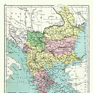
Central Europe and the Mediterranean, 1919. Creator: London Geographical Institute

![]()
Wall Art and Photo Gifts from Heritage Images
Central Europe and the Mediterranean, 1919. Creator: London Geographical Institute
Central Europe and the Mediterranean, 1919. Showing naval dockyards, fortified coastal towns, and forts. From " The History of the Great European War: its causes and effects", Vol. III, by W. Stanley Macbean Knight. [Caxton Pulishing Company, Limited, London, 1919]
Heritage Images features heritage image collections
Media ID 19048079
© The Print Collector/Heritage Images
Austria Hungary Austro Hungarian Black Sea Bulgaria Caxton Publishing Company Caxton Pulishing Company Caxton Pulishing Company Lim Caxton Pulishing Company Limited Caxton Pulishing Company Ltd Great Britain Knight Limited London Geographical Institute Mediterranean Mediterranean Sea North Africa Portugal Romania Serbia Stanley Macbean Stanley Macbean Knight Tunisia Turkey Turkish W Stanley Macbean W Stanley Macbean Knight William Stanley Macbean William Stanley Macbean Knight 1st World War
FEATURES IN THESE COLLECTIONS
> Asia
> Turkey
> Related Images
EDITORS COMMENTS
This print from 1919, created by the London Geographical Institute, offers a detailed glimpse into Central Europe and the Mediterranean during a pivotal moment in history. The image showcases naval dockyards, fortified coastal towns, and forts that played significant roles in World War I. Extracted from "The History of the Great European War: its causes and effects" by W. Stanley Macbean Knight, this print provides invaluable insights into the geopolitical landscape of the time. With vibrant colors bringing life to this century-old map, viewers can trace their eyes across continents and countries such as Austria-Hungary, Belgium, France, Germany, Greece, Italy, Portugal, Romania Russia Serbia Spain Tunisia Turkey and more. Notably capturing North Africa's presence along with the Black Sea region adds depth to our understanding of global dynamics during this era. As we delve deeper into each intricate detail on this map – meticulously crafted by William Stanley Macbean Knight – it becomes evident that every line represents a story waiting to be explored. This historical artifact not only serves as an educational resource but also ignites curiosity about how these locations have evolved over time. Preserved by The Print Collector for generations to come; it is a testament to human resilience amidst conflict and change. Let us cherish this remarkable piece of history as we reflect upon the impact of World War I on Central Europe and the Mediterranean region.
MADE IN THE USA
Safe Shipping with 30 Day Money Back Guarantee
FREE PERSONALISATION*
We are proud to offer a range of customisation features including Personalised Captions, Color Filters and Picture Zoom Tools
SECURE PAYMENTS
We happily accept a wide range of payment options so you can pay for the things you need in the way that is most convenient for you
* Options may vary by product and licensing agreement. Zoomed Pictures can be adjusted in the Cart.