Home > North America > United States of America > New York > New York > Maps
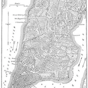
The Commissoners map of the city of New York, 1807. Wood engraving, American, 19th century

![]()
Wall Art and Photo Gifts from Granger
The Commissoners map of the city of New York, 1807. Wood engraving, American, 19th century
NEW YORK CITY MAP, 1807.
The Commissoners map of the city of New York, 1807. Wood engraving, American, 19th century
Granger holds millions of images spanning more than 25,000 years of world history, from before the Stone Age to the dawn of the Space Age
Media ID 10411286
1807 Manhattan Plan Topography United States
FEATURES IN THESE COLLECTIONS
> Arts
> Portraits
> Pop art gallery
> Street art portraits
> Granger Art on Demand
> Plans and Diagrams
> Maps and Charts
> Early Maps
> North America
> United States of America
> New York
> New York
> Manhattan
> Related Images
> North America
> United States of America
> New York
> New York
> Maps
The Commissioners Map of the City of New York, 1807 - A Glimpse into Early American Urban Planning
EDITORS COMMENTS
. This wood engraving from the 19th century takes us back to a pivotal moment in the history of New York City. Known as "The Commissioners Map" this meticulously detailed print offers a unique perspective on the city's topography and layout during its early years. As we gaze upon this remarkable piece, we are transported to a time when Manhattan was still evolving into the bustling metropolis it is today. The streets depicted here are far quieter than what we see now, with horse-drawn carriages traversing cobblestone roads lined by quaint buildings. What makes this map truly fascinating is its role in urban planning. Created by commissioners tasked with organizing and expanding the growing city, it provides insight into their vision for New York's future development. Every street and block has been carefully plotted, revealing an intricate network that would shape the cityscape for generations to come. Beyond its historical significance, this wood engraving showcases America's spirit of progress during the early 19th century. It serves as a testament to our nation's determination to build thriving cities that would become beacons of opportunity and innovation. Whether you're an avid historian or simply captivated by vintage maps, "The Commissioners Map" transports you back in time—a window into an era when New York City was just beginning its ascent towards becoming one of North America's most iconic urban landscapes.
MADE IN THE USA
Safe Shipping with 30 Day Money Back Guarantee
FREE PERSONALISATION*
We are proud to offer a range of customisation features including Personalised Captions, Color Filters and Picture Zoom Tools
FREE COLORIZATION SERVICE
You can choose advanced AI Colorization for this picture at no extra charge!
SECURE PAYMENTS
We happily accept a wide range of payment options so you can pay for the things you need in the way that is most convenient for you
* Options may vary by product and licensing agreement. Zoomed Pictures can be adjusted in the Cart.