Home > Europe > United Kingdom > England > Maps
COLONIAL CAROLINA MAP. The earliest map of Carolina

![]()
Wall Art and Photo Gifts from Granger
COLONIAL CAROLINA MAP. The earliest map of Carolina
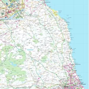
COLONIAL CAROLINA MAP.
The earliest map of Carolina. From A Brief Description of the Province of Carolina, London, England, 1666
Granger holds millions of images spanning more than 25,000 years of world history, from before the Stone Age to the dawn of the Space Age
Media ID 12225914
1666 Cartouche Coast Colony East New World North Carolina Province South Carolina Southeastern United States
FEATURES IN THESE COLLECTIONS
> Arts
> Landscape paintings
> Waterfall and river artworks
> River artworks
> Europe
> United Kingdom
> England
> London
> Related Images
> Europe
> United Kingdom
> England
> Maps
> Europe
> United Kingdom
> England
> Rivers
> Granger Art on Demand
> American History
> Maps and Charts
> World
EDITORS COMMENTS
This print showcases the "Colonial Carolina Map" which is hailed as the earliest depiction of Carolina. Published in London, England in 1666, this historic map offers a fascinating glimpse into the New World during colonial times. The intricate details and exquisite craftsmanship of this map are truly remarkable. It features a cartouche that adds an artistic touch to its overall composition, while accurately depicting the coastlines, rivers, and provinces of both North and South Carolina. The map also highlights the middle and southeastern regions of what would later become the United States. As we delve into this piece of history, we can't help but marvel at how it provides valuable insights into America's colonial past. It serves as a testament to the explorers who ventured across uncharted territories and laid claim to new lands. This print from Granger Art on Demand allows us to appreciate not only the historical significance but also the aesthetic beauty of this early representation of Colonial Carolina. Whether you're an American history enthusiast or simply captivated by maps, this artwork transports you back in time to an era when these lands were still being discovered.
MADE IN THE USA
Safe Shipping with 30 Day Money Back Guarantee
FREE PERSONALISATION*
We are proud to offer a range of customisation features including Personalised Captions, Color Filters and Picture Zoom Tools
SECURE PAYMENTS
We happily accept a wide range of payment options so you can pay for the things you need in the way that is most convenient for you
* Options may vary by product and licensing agreement. Zoomed Pictures can be adjusted in the Cart.