Framed Print > Universal Images Group (UIG) > Art > Painting, Sculpture & Prints > Cartography
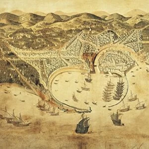
Framed Print : Genoa Signoria, Nice County and Northern Corsica, Map by Claude Jollain from the Tresor des Cartes Geographiques des Principaux Estats de l Univers, Copper engraving, 1667


![]()
Framed Photos from Universal Images Group (UIG)
Genoa Signoria, Nice County and Northern Corsica, Map by Claude Jollain from the Tresor des Cartes Geographiques des Principaux Estats de l Univers, Copper engraving, 1667
Cartography, 17th century. Genoa Signoria, Nice County and Northern Corsica. Map by Claude Jollain from the Tresor des Cartes Geographiques des Principaux Estats de l Univers, 1667. Copper engraving
Universal Images Group (UIG) manages distribution for many leading specialist agencies worldwide
Media ID 9572433
© DEA PICTURE LIBRARY
12"x10" Modern Frame
Discover the rich history of Europe with our stunning Framed Prints from Media Storehouse. This exquisite map, created by Claude Jollain in 1667, showcases the Genoa Signoria, Nice County, and Northern Corsica. Part of the Tresor des Cartes Geographiques des Principaux Estats de l Univers collection, this copper engraving transports you back in time to the 17th century. The intricate details and vibrant colors bring the regions to life, making this a beautiful addition to any home or office. Our Framed Prints are made with museum-quality materials, ensuring your new treasure will last for generations to come.
10x8 Print in an MDF Wooden Frame with 180 gsm Satin Finish Paper. Glazed using shatter proof thin plexi glass. Frame thickness is 1 inch and depth 0.75 inch. Fluted cardboard backing held with clips. Supplied ready to hang with sawtooth hanger and rubber bumpers. Spot clean with a damp cloth. Packaged foam wrapped in a card.
Contemporary Framed and Mounted Prints - Professionally Made and Ready to Hang
Estimated Image Size (if not cropped) is 25.4cm x 25.4cm (10" x 10")
Estimated Product Size is 30.5cm x 25.4cm (12" x 10")
These are individually made so all sizes are approximate
Artwork printed orientated as per the preview above, with landscape (horizontal) or portrait (vertical) orientation to match the source image.
EDITORS COMMENTS
This 17th-century map, created by Claude Jollain and printed in 1667, offers a glimpse into the historical geography of Genoa Signoria, Nice County, and Northern Corsica. Crafted through the meticulous art of copper engraving, this antique piece showcases the intricate details that were characteristic of cartography during this era. The map is part of the renowned Tresor des Cartes Geographiques des Principaux Estats de l Univers collection, which translates to "Treasury of Geographical Maps of the Principal States of the Universe". It serves as a testament to Jollain's skill as an illustrator and painter in capturing geographical nuances with precision. With its horizontal orientation and absence of people, this illustration transports us back in time to explore these regions untouched by modern development. The map not only provides valuable insights into historical boundaries but also acts as a visual representation of how these areas were perceived centuries ago. As we delve into history through this remarkable piece, we can appreciate its significance beyond commercial use. Its presence reminds us that maps are not just tools for navigation; they hold stories about our past and shed light on how societies have evolved over time. This print from Universal Images Group (UIG) invites us to embark on a journey through time and immerse ourselves in the rich history embedded within its delicate engravings.
MADE IN THE USA
Safe Shipping with 30 Day Money Back Guarantee
FREE PERSONALISATION*
We are proud to offer a range of customisation features including Personalised Captions, Color Filters and Picture Zoom Tools
SECURE PAYMENTS
We happily accept a wide range of payment options so you can pay for the things you need in the way that is most convenient for you
* Options may vary by product and licensing agreement. Zoomed Pictures can be adjusted in the Cart.