Framed Print > Europe > Spain > Related Images
Framed Print : An Ottoman map of the Iberian Peninsula


![]()
Framed Photos From Mary Evans Picture Library
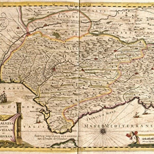
An Ottoman map of the Iberian Peninsula
An Ottoman map of the Iberian Peninsula Date: circa 1890s
Mary Evans Picture Library makes available wonderful images created for people to enjoy over the centuries
Media ID 14376928
© Mary Evans / Grenville Collins Postcard Collection
Chart Dec15 Gibraltar Iberia Iberian Peninsula Plan Portugal Portuguese Scale Script Ottoman
12"x10" Modern Frame
Discover the rich history of the Iberian Peninsula with our exquisite Framed Prints from Media Storehouse. This captivating piece showcases an Ottoman map of the Iberian Peninsula, dated circa 1890s, sourced from Mary Evans Prints Online. The intricate details of this antique map reveal the political landscape of the region during the Ottoman Empire's expansion. Each print is meticulously framed in a style that complements the historical significance of the image, making it a stunning addition to your home or office. Bring a piece of the past into your present with our Framed Prints collection.
10x8 Print in an MDF Wooden Frame with 180 gsm Satin Finish Paper. Glazed using shatter proof thin plexi glass. Frame thickness is 1 inch and depth 0.75 inch. Fluted cardboard backing held with clips. Supplied ready to hang with sawtooth hanger and rubber bumpers. Spot clean with a damp cloth. Packaged foam wrapped in a card.
Contemporary Framed and Mounted Prints - Professionally Made and Ready to Hang
Estimated Image Size (if not cropped) is 25.4cm x 18.1cm (10" x 7.1")
Estimated Product Size is 30.5cm x 25.4cm (12" x 10")
These are individually made so all sizes are approximate
Artwork printed orientated as per the preview above, with landscape (horizontal) orientation to match the source image.
MADE IN THE USA
Safe Shipping with 30 Day Money Back Guarantee
FREE PERSONALISATION*
We are proud to offer a range of customisation features including Personalised Captions, Color Filters and Picture Zoom Tools
SECURE PAYMENTS
We happily accept a wide range of payment options so you can pay for the things you need in the way that is most convenient for you
* Options may vary by product and licensing agreement. Zoomed Pictures can be adjusted in the Basket.