Framed Print > Maps and Charts > Related Images
Framed Print : Map - Trinidad


![]()
Framed Photos from Mary Evans Picture Library
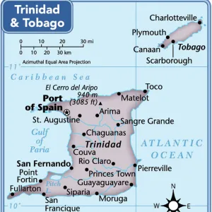
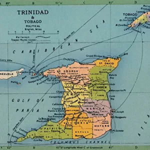
Map - Trinidad
Map - Trinidad - West Indies - Caribbean Sea. Date: circa 1860
Mary Evans Picture Library makes available wonderful images created for people to enjoy over the centuries
Media ID 20147625
© Bubblepunk
18"x14" Modern Frame
Step back in time with our exquisite Framed Prints from Media Storehouse, featuring this captivating map of Trinidad from Mary Evans Prints Online. Dating back to circa 1860, this vintage map showcases the intricate details of the West Indies and the Caribbean Sea, with Trinidad prominently displayed. Add a touch of history and character to your décor with this beautifully framed, collectible piece. Perfect for the office, living room, or as a thoughtful gift, this Framed Print is a must-have for any history or cartography enthusiast. Embrace the charm of the past with Media Storehouse.
16x12 Print in an MDF Wooden Frame with 180 gsm Satin Finish Paper. Glazed using shatter proof thin plexiglass. Frame thickness is 1 inch and depth 0.75 inch. Fluted cardboard backing held with clips. Supplied ready to hang with sawtooth hanger and rubber bumpers. Spot clean with a damp cloth. Packaged foam wrapped in a card.
Contemporary Framed and Mounted Prints - Professionally Made and Ready to Hang
Estimated Image Size (if not cropped) is 40.6cm x 35.6cm (16" x 14")
Estimated Product Size is 45.7cm x 35.6cm (18" x 14")
These are individually made so all sizes are approximate
Artwork printed orientated as per the preview above, with landscape (horizontal) orientation to match the source image.
FEATURES IN THESE COLLECTIONS
> Maps and Charts
> Related Images
> Mary Evans Prints Online
> New Images July 2020
EDITORS COMMENTS
This antique map print, titled 'Trinidad,' dates back to circa 1860 and offers a fascinating glimpse into the geography and cartography of the West Indies during that era. The map, available from Mary Evans Prints Online, features the island of Trinidad and its surrounding waters in the Caribbean Sea. At the heart of the map lies the island of Trinidad, depicted with intricate detail, showcasing its various bays, inlets, and peninsulas. The island's topography is rendered in meticulous detail, with mountains, rivers, and forests all clearly marked. The coastline is dotted with settlements and towns, some of which are named, offering a glimpse into the human presence on the island. The waters surrounding Trinidad are also depicted with care, with various islands and reefs marked, as well as shipping lanes and other navigational features. The map also includes a small inset map of the Gulf of Paria, located to the north of Trinidad, which further illustrates the complex geography of the region. The map's cartouche, located in the bottom right corner, includes an elegant illustration of a native West Indian woman, dressed in traditional attire, holding a fruit and a fan. The map's title, 'Trinidad,' is written in elegant script above her head, while the date, 'Circa 1860,' is inscribed below. This beautiful antique map print not only serves as a valuable historical document, but also as a stunning work of art, showcasing the intricate detail and craftsmanship of mapmaking during the 19th century. Whether for personal collection or as a decorative addition to a room, this map of Trinidad is sure to captivate and inspire.
MADE IN THE USA
Safe Shipping with 30 Day Money Back Guarantee
FREE PERSONALISATION*
We are proud to offer a range of customisation features including Personalised Captions, Color Filters and Picture Zoom Tools
SECURE PAYMENTS
We happily accept a wide range of payment options so you can pay for the things you need in the way that is most convenient for you
* Options may vary by product and licensing agreement. Zoomed Pictures can be adjusted in the Cart.