Framed Print > Maps and Charts > Early Maps
Framed Print : Napoleon / St Helena Map


![]()
Framed Photos from Mary Evans Picture Library
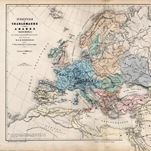
Napoleon / St Helena Map
NAPOLEON I Map of the island of Saint Helena during his captivity
Mary Evans Picture Library makes available wonderful images created for people to enjoy over the centuries
Media ID 584860
© Mary Evans Picture Library 2015 - https://copyrighthub.org/s0/hub1/creation/maryevans/MaryEvansPictureID/10038155
1815 1821 Captivity Helena Napoleon Places
18"x14" Modern Frame
Introducing the Napoleon/St Helena Map Framed Print from the Media Storehouse collection, brought to you in collaboration with Mary Evans Picture Library. This captivating piece of historical art showcases an intriguing moment in time, depicting the island of Saint Helena during Napoleon Bonaparte's exile. The map offers a fascinating glimpse into the details of the remote location where the legendary French military and political leader spent the final years of his life. The high-quality print is beautifully framed, adding an elegant touch to any room while providing a captivating conversation starter. Delve into history and bring this significant moment to life with the Napoleon/St Helena Map Framed Print.
16x12 Print in an MDF Wooden Frame with 180 gsm Satin Finish Paper. Glazed using shatter proof thin plexiglass. Frame thickness is 1 inch and depth 0.75 inch. Fluted cardboard backing held with clips. Supplied ready to hang with sawtooth hanger and rubber bumpers. Spot clean with a damp cloth. Packaged foam wrapped in a card.
Contemporary Framed and Mounted Prints - Professionally Made and Ready to Hang
Estimated Image Size (if not cropped) is 40.6cm x 35.6cm (16" x 14")
Estimated Product Size is 45.7cm x 35.6cm (18" x 14")
These are individually made so all sizes are approximate
Artwork printed orientated as per the preview above, with landscape (horizontal) orientation to match the source image.
FEATURES IN THESE COLLECTIONS
> Maps and Charts
> Early Maps
> Maps and Charts
> Related Images
EDITORS COMMENTS
This fascinating historical print depicts a map of the island of Saint Helena during Napoleon Bonaparte's captivity in 1815. The detailed map showcases the various locations on the remote island where Napoleon was exiled after his defeat at the Battle of Waterloo. From Longwood House, where he resided during his time on the island, to Deadwood Plain where he would often take walks, this map provides a glimpse into Napoleon's daily life during his final years.
The intricate details and accuracy of this map offer a unique perspective on one of history's most iconic figures. It allows us to visualize the confines within which Napoleon lived out his days far from the grandeur and power he once held as Emperor of France.
As we study this map, we can't help but feel a sense of intrigue and curiosity about Napoleon's thoughts and emotions as he navigated through his confinement on Saint Helena. It serves as a reminder of both the heights of ambition and glory that Napoleon achieved, as well as the depths of despair and isolation that marked his later years.
Overall, this print is not just a geographical representation but also a window into an important chapter in world history - making it a valuable addition to any collection or display showcasing significant moments from the past.
MADE IN THE USA
Safe Shipping with 30 Day Money Back Guarantee
FREE PERSONALISATION*
We are proud to offer a range of customisation features including Personalised Captions, Color Filters and Picture Zoom Tools
SECURE PAYMENTS
We happily accept a wide range of payment options so you can pay for the things you need in the way that is most convenient for you
* Options may vary by product and licensing agreement. Zoomed Pictures can be adjusted in the Cart.