Home > Africa > Related Images
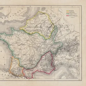
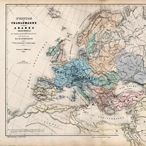
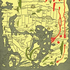
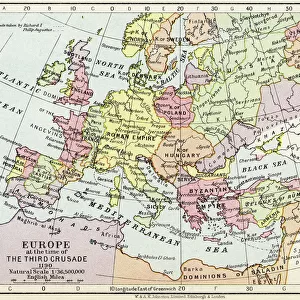
Sketch of the great empires in the time of Charlemagne (engraving)
")
![]()
Wall Art and Photo Gifts from Fine Art Finder
Sketch of the great empires in the time of Charlemagne (engraving)
974073 Sketch of the great empires in the time of Charlemagne (engraving) by English School, (19th century); Private Collection; (add.info.: Sketch of the great empires in the time of Charlemagne. Illustration from The History of the Decline and Fall of the Roman Empire (Volume II) by Edward Gibbon (G Virtue, London and New York). Digitally cleaned image.); © Look and Learn
Media ID 23517078
© Look and Learn / Bridgeman Images
8 8th Viii Viiith Century 8 Century 8th Century 9 9th 9th 9th Century 9 9th Ix Ixth Century 9 Century 9th Century C8th C9th Charlemagne Eighth Century Empires Ix Century Ixth Century Viii Century Viiith Century
FEATURES IN THESE COLLECTIONS
> Africa
> Related Images
> Arts
> Artists
> R
> Roman Roman
> Arts
> Street art graffiti
> Digital art
> Digital paintings
> Asia
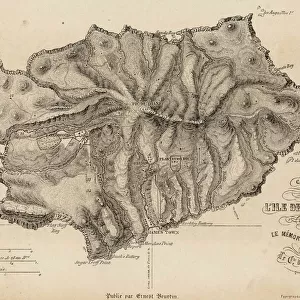
> East Timor
> Maps
> Asia
> East Timor
> Related Images
> Asia
> Related Images
> Fine Art Finder
> Artists
> English School
> Fine Art Finder
> Artists
> French School
> Fine Art Finder
> Temp Classification
> Historic
> Ancient civilizations
> Roman Empire
> Roman art
> Maps and Charts
> Related Images
EDITORS COMMENTS
This engraving, titled "Sketch of the great empires in the time of Charlemagne" takes us on a journey back to the 8th and 9th centuries. Created by an English School artist in the 19th century, this print offers a glimpse into a pivotal era in European history. The intricate map showcases the vast territories ruled by various empires during Charlemagne's reign. From Europe to Asia, Africa to the Middle East, it vividly illustrates how power was distributed across these regions at that time. The attention to detail is remarkable as each empire is meticulously labeled and delineated. Originally featured in Edward Gibbon's renowned work "The History of the Decline and Fall of the Roman Empire" this engraving has been digitally cleaned for enhanced clarity. Its inclusion in Gibbon's historical masterpiece speaks volumes about its significance as a visual representation of past civilizations. As we explore this artwork, we are transported back through centuries, witnessing how different cultures thrived and interacted during Charlemagne's rule. It serves as a reminder of our shared human history and highlights how geopolitical landscapes have evolved over time. With its rich historical context and meticulous craftsmanship, this print from Fine Art Finder allows us to appreciate both artistry and knowledge simultaneously. It invites us to delve deeper into our collective past while marveling at the beauty captured within this intricately detailed sketch.
MADE IN THE USA
Safe Shipping with 30 Day Money Back Guarantee
FREE PERSONALISATION*
We are proud to offer a range of customisation features including Personalised Captions, Color Filters and Picture Zoom Tools
SECURE PAYMENTS
We happily accept a wide range of payment options so you can pay for the things you need in the way that is most convenient for you
* Options may vary by product and licensing agreement. Zoomed Pictures can be adjusted in the Cart.