Framed Print > Europe > United Kingdom > England > London > Towns > Paddington
Framed Print : Map of the St Marylebone area, London


![]()
Framed Photos From Mary Evans Picture Library
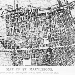
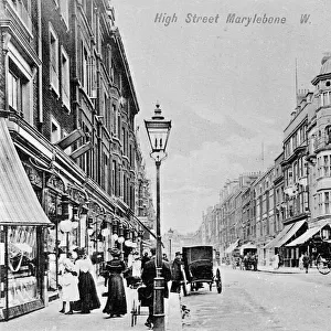
Map of the St Marylebone area, London
Map of the St Marylebone area, London. Date: circa 1900
Mary Evans Picture Library makes available wonderful images created for people to enjoy over the centuries
Media ID 14262928
© Mary Evans / Pharcide
Area Burial Cemetery Edgware Hyde Maps Marylebone Paddington Squares Stations Tyburn
12"x10" Modern Frame
Discover the rich history of London's St Marylebone neighborhood with our exquisite framed print from Media Storehouse. This beautifully detailed map, dated circa 1900, showcases the area's historic streets and landmarks, sourced from the extensive collection at Mary Evans Prints Online. Bring a piece of London's past into your home or office with this rights managed, high-quality framed print. A perfect addition to any room, this framed map is sure to ignite conversation and inspire a deeper appreciation for the history and character of St Marylebone.
10x8 Print in an MDF Wooden Frame with 180 gsm Satin Finish Paper. Glazed using shatter proof thin plexi glass. Frame thickness is 1 inch and depth 0.75 inch. Fluted cardboard backing held with clips. Supplied ready to hang with sawtooth hanger and rubber bumpers. Spot clean with a damp cloth. Packaged foam wrapped in a card.
Contemporary Framed and Mounted Prints - Professionally Made and Ready to Hang
Estimated Image Size (if not cropped) is 25.4cm x 25.4cm (10" x 10")
Estimated Product Size is 30.5cm x 25.4cm (12" x 10")
These are individually made so all sizes are approximate
Artwork printed orientated as per the preview above, with landscape (horizontal) or portrait (vertical) orientation to match the source image.
FEATURES IN THESE COLLECTIONS
> Arts
> Portraits
> Pop art gallery
> Street art portraits
> Europe
> United Kingdom
> England
> London
> Sights
> Hyde Park
> Europe
> United Kingdom
> England
> London
> Towns
> The Hyde
> Europe
> United Kingdom
> England
> London
> Towns
> Marylebone
> Europe
> United Kingdom
> England
> London
> Towns
> Paddington
> Europe
> United Kingdom
> England
> Maps
> Europe
> United Kingdom
> England
> Posters
> Maps and Charts
> Related Images
EDITORS COMMENTS
Step back in time with this map print of the St Marylebone area in London, circa 1900. This intricately detailed map transports us back to the Victorian and Edwardian eras, showcasing the intricate network of streets and roads that crisscrossed this historic district. The map reveals the heart of St Marylebone, with its bustling commercial areas around Oxford Street and Regent Street, as well as the tranquil squares and gardens, including the renowned Regent's Park and Hyde Park. The map also highlights the various stations of the Metropolitan and District Railways, including Paddington and Edgware Road, which were essential hubs of transportation during this period. One cannot discuss St Marylebone without mentioning its rich history. The map reveals the location of Tyburn Convent and Cemetery, a significant part of the area's past. Tyburn, also known as the "Gibbet Field," was once the site of public executions and a burial ground. The area's name derives from the Old English word "typing," meaning a gallows. As we explore this map, we are transported back to an era of horse-drawn carriages, grand Victorian houses, and the bustling energy of London's streets. A must-have for history enthusiasts, this map print is a beautiful addition to any home or office, providing a glimpse into the past and a reminder of the rich history that lies within the heart of London.
MADE IN THE USA
Safe Shipping with 30 Day Money Back Guarantee
FREE PERSONALISATION*
We are proud to offer a range of customisation features including Personalised Captions, Color Filters and Picture Zoom Tools
SECURE PAYMENTS
We happily accept a wide range of payment options so you can pay for the things you need in the way that is most convenient for you
* Options may vary by product and licensing agreement. Zoomed Pictures can be adjusted in the Basket.