Framed Print > Arts > Artists > M > Thomas Moule
Framed Print : Old Map of the City of Bath 1836 by Thomas Moule


![]()
Framed Photos From MapSeeker
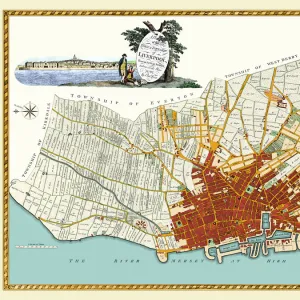
Old Map of the City of Bath 1836 by Thomas Moule
This is a fine decorative reproduction Map of The City of Bath from the First Edition series of Thomas Moule Maps, originally Published in 1836
Welcome to the Mapseeker Image library and enter an historic gateway to one of the largest on-line collections of Historic Maps, Nostalgic Views, Vista's and Panorama's from a World gone by.
Media ID 20348239
Historic Map Moule Map Old Town Plan Thomas Moule Thomas Moule Map Town Plan Bath City
12"x10" Modern Frame
Introduce a touch of historical charm to your space with the Media Storehouse Framed Print of the Old Map of The City of Bath by Thomas Moule. This exquisite reproduction is taken from the First Edition series of Thomas Moule Maps, originally published in 1836. The intricate details and vibrant colors of this Old Map showcase the beauty and character of Bath as it was over 180 years ago. Each print is carefully framed with a elegant and timeless design, making it a perfect addition to any room in your home or office. Bring history into your world with the Media Storehouse Framed Print of the Old Map of The City of Bath by Thomas Moule.
10x8 Print in an MDF Wooden Frame with 180 gsm Satin Finish Paper. Glazed using shatter proof thin plexi glass. Frame thickness is 1 inch and depth 0.75 inch. Fluted cardboard backing held with clips. Supplied ready to hang with sawtooth hanger and rubber bumpers. Spot clean with a damp cloth. Packaged foam wrapped in a card.
Contemporary Framed and Mounted Prints - Professionally Made and Ready to Hang
Estimated Image Size (if not cropped) is 25.4cm x 25.4cm (10" x 10")
Estimated Product Size is 25.4cm x 30.5cm (10" x 12")
These are individually made so all sizes are approximate
Artwork printed orientated as per the preview above, with landscape (horizontal) or portrait (vertical) orientation to match the source image.
FEATURES IN THESE COLLECTIONS
> Arts
> Artists
> M
> Thomas Moule
> MapSeeker
> British Town And City Plans
> English & Welsh PORTFOLIO
EDITORS COMMENTS
This stunning print showcases the "Old Map of the City of Bath 1836" by Thomas Moule, a renowned cartographer from the early 19th century. This fine decorative reproduction is part of the First Edition series of Thomas Moule Maps, originally published in 1836. The map offers a captivating glimpse into the historic city of Bath, capturing its intricate layout and architectural beauty during that era. With meticulous detail, it presents an invaluable resource for historians, urban planners, and enthusiasts alike. Thomas Moule's expertise shines through as he masterfully depicts every street, square, and landmark within this vibrant city. The town plan provides a fascinating insight into how Bath has evolved over time while retaining its timeless charm. This particular print serves as a testament to both Moule's skill as a cartographer and his passion for preserving history through maps. It allows us to appreciate Bath's rich heritage and invites us to explore its streets with our imagination. Whether you are an avid collector or simply captivated by historical maps, this print is sure to be a cherished addition to any space. Its elegant design and attention to detail make it an exquisite piece that celebrates not only Bath but also the artistry behind creating these remarkable historical documents.
MADE IN THE USA
Safe Shipping with 30 Day Money Back Guarantee
FREE PERSONALISATION*
We are proud to offer a range of customisation features including Personalised Captions, Color Filters and Picture Zoom Tools
SECURE PAYMENTS
We happily accept a wide range of payment options so you can pay for the things you need in the way that is most convenient for you
* Options may vary by product and licensing agreement. Zoomed Pictures can be adjusted in the Basket.