Framed Print > Europe > United Kingdom > Scotland > Fife > St Andrews
Framed Print : Spelthorne TW19 5 Map


![]()
Framed Photos from Map Marketing
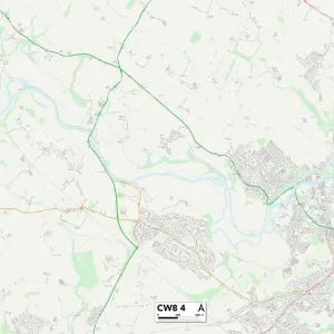
Spelthorne TW19 5 Map
Postcode Sector Map of Spelthorne TW19 5
Media ID 19982236
Acacia Avenue Brookside Avenue Coppice Drive Fairfield Road Friary Road Grange Close High Street Hill View Road Nursery Way Old School Court Park Avenue Riverside Spelthorne St Andrews Close Staines Road Station Road The Avenue The Drive The Embankment The Green Vicarage Lane Wharf Road Whitehall Lane Windsor Road Harcourt
12"x10" Modern Frame
10x8 Print in an MDF Wooden Frame with 180 gsm Satin Finish Paper. Glazed using shatter proof thin plexi glass. Frame thickness is 1 inch and depth 0.75 inch. Fluted cardboard backing held with clips. Supplied ready to hang with sawtooth hanger and rubber bumpers. Spot clean with a damp cloth. Packaged foam wrapped in a card.
Contemporary Framed and Mounted Prints - Professionally Made and Ready to Hang
Estimated Image Size (if not cropped) is 25.4cm x 25.4cm (10" x 10")
Estimated Product Size is 30.5cm x 25.4cm (12" x 10")
These are individually made so all sizes are approximate
Artwork printed orientated as per the preview above, with landscape (horizontal) or portrait (vertical) orientation to match the source image.
FEATURES IN THESE COLLECTIONS
> Arts
> Artists
> H
> John Hillers
> Arts
> Artists
> H
> John Hills
> Europe
> United Kingdom
> Scotland
> Fife
> St Andrews
> Maps and Charts
> Related Images
> Map Marketing
> Postcode Sector Maps
> TW - Twickenham
MADE IN THE USA
Safe Shipping with 30 Day Money Back Guarantee
FREE PERSONALISATION*
We are proud to offer a range of customisation features including Personalised Captions, Color Filters and Picture Zoom Tools
SECURE PAYMENTS
We happily accept a wide range of payment options so you can pay for the things you need in the way that is most convenient for you
* Options may vary by product and licensing agreement. Zoomed Pictures can be adjusted in the Cart.