Framed Print > Europe > United Kingdom > England > Maps
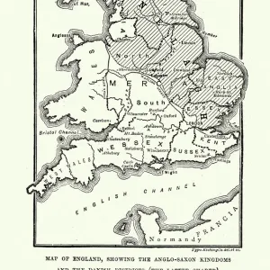
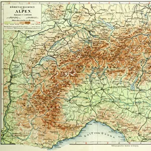
Framed Print : Map of England Showing the Anglo-Saxon Kingdoms and Danish Districts


![]()
Framed Photos from Liszt Collection
Map of England Showing the Anglo-Saxon Kingdoms and Danish Districts
Liszt Collection of nineteenth-century engravings and images to browse and enjoy
Media ID 12978366
© Quint Lox Limited
Anglo Saxon Danish Districts Kingdoms Plan Showing
18"x14" Modern Frame
Introducing the captivating "Map of England Showing the Anglo-Saxon Kingdoms and Danish Districts" from the 000031 collection at Media Storehouse. This exquisite framed print transports you back in time, showcasing the historical territories of Anglo-Saxon kingdoms and Danish districts in England during the early Middle Ages. Crafted from premium materials, this intricately detailed map is an essential addition to any history enthusiast's collection or a unique decorative piece for your home or office. With its antique, aged look, the map adds an air of sophistication and character to any space. The high-quality framing ensures the map is protected and beautifully presented, allowing you to appreciate the intricate details of this historical masterpiece. Explore the rich history of England and celebrate the legacy of its Anglo-Saxon and Danish past with the "Map of England Showing the Anglo-Saxon Kingdoms and Danish Districts" from Media Storehouse.
16x12 Print in an MDF Wooden Frame with 180 gsm Satin Finish Paper. Glazed using shatter proof thin plexiglass. Frame thickness is 1 inch and depth 0.75 inch. Fluted cardboard backing held with clips. Supplied ready to hang with sawtooth hanger and rubber bumpers. Spot clean with a damp cloth. Packaged foam wrapped in a card.
Contemporary Framed and Mounted Prints - Professionally Made and Ready to Hang
Estimated Image Size (if not cropped) is 35.6cm x 40.6cm (14" x 16")
Estimated Product Size is 35.6cm x 45.7cm (14" x 18")
These are individually made so all sizes are approximate
Artwork printed orientated as per the preview above, with portrait (vertical) orientation to match the source image.
FEATURES IN THESE COLLECTIONS
> Europe
> Denmark
> Related Images
> Europe
> United Kingdom
> England
> Maps
> Maps and Charts
> Related Images
> Liszt Collection
> Engravings
> Nineteenth Century Engraving
EDITORS COMMENTS
This nineteenth-century engraving titled "Map of England Showing the Anglo-Saxon Kingdoms and Danish Districts" takes us on a journey back in time to explore the rich history of England. The intricately detailed map showcases the various Anglo-Saxon kingdoms and Danish districts that once shaped the landscape of this ancient land. With its retro-styled vintage appeal, this engraved image is not only a testament to Victorian arts and culture but also an illustrative technique that transports us into a bygone era. The engravement technique used in creating this print adds depth and texture, enhancing our visual experience as we study each kingdom and district meticulously depicted on the map. The Map of England serves as both a plan and chart, allowing us to delve into historical narratives while appreciating its artistic value. It offers a glimpse into how boundaries were drawn during that period, shedding light on political dynamics between different regions. As we observe this piece from Liszt Collection's vast archives, we are reminded of the importance of preserving cultural heritage through art. This print invites us to reflect upon our roots, fostering an appreciation for history's role in shaping our present-day society. Whether you are an avid historian or simply captivated by vintage aesthetics, this enchanting depiction will undoubtedly spark curiosity about England's past and leave you yearning for more knowledge about these fascinating Anglo-Saxon kingdoms and Danish districts.
MADE IN THE USA
Safe Shipping with 30 Day Money Back Guarantee
FREE PERSONALISATION*
We are proud to offer a range of customisation features including Personalised Captions, Color Filters and Picture Zoom Tools
SECURE PAYMENTS
We happily accept a wide range of payment options so you can pay for the things you need in the way that is most convenient for you
* Options may vary by product and licensing agreement. Zoomed Pictures can be adjusted in the Cart.