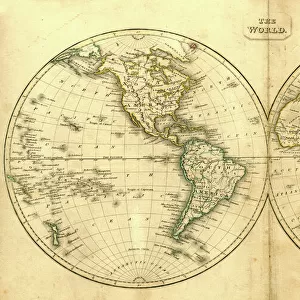
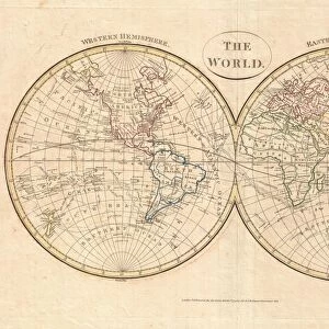
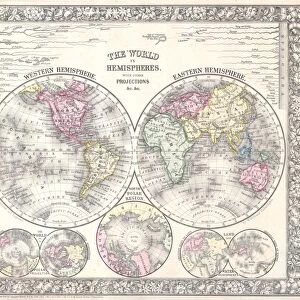
Framed Print : 1862, Stieler Hemisphere Map of the World, topography, cartography, geography, land


![]()
Framed Photos From Liszt Collection
1862, Stieler Hemisphere Map of the World, topography, cartography, geography, land
1862, Stieler Hemisphere Map of the World
Liszt Collection of nineteenth-century engravings and images to browse and enjoy
Media ID 14007807
© Artokoloro Quint Lox Limited
1862 Antique Map Latitude Longitude Mappa Mundi Old Antique Plan Old Antique View Ols Antique Map Rare Old Maps Topo
12"x10" Modern Frame
Discover the wonders of the world's geography with our stunning Framed Prints from the Media Storehouse collection. This captivating piece features the 1862 Stieler Hemisphere Map of the World, meticulously sourced from the renowned Liszt Collection. With intricate topography, cartography, and geographical details, this map transports you back in time to an era of exploration and discovery. Each print is carefully framed in a sophisticated design, making it a perfect addition to any home or office space. Bring history into your living space and ignite a sense of adventure with this beautiful and educational Framed Print.
10x8 Print in an MDF Wooden Frame with 180 gsm Satin Finish Paper. Glazed using shatter proof thin plexi glass. Frame thickness is 1 inch and depth 0.75 inch. Fluted cardboard backing held with clips. Supplied ready to hang with sawtooth hanger and rubber bumpers. Spot clean with a damp cloth. Packaged foam wrapped in a card.
Contemporary Framed and Mounted Prints - Professionally Made and Ready to Hang
Estimated Image Size (if not cropped) is 25.4cm x 25.4cm (10" x 10")
Estimated Product Size is 30.5cm x 25.4cm (12" x 10")
These are individually made so all sizes are approximate
Artwork printed orientated as per the preview above, with landscape (horizontal) or portrait (vertical) orientation to match the source image.
EDITORS COMMENTS
This print showcases the intricate details of the "1862, Stieler Hemisphere Map of the World". A true masterpiece in cartography, this vintage map takes us back to a time when exploration and discovery were at their peak. The topography and geography are meticulously depicted, offering a glimpse into how our ancestors perceived the Earth. The artist's skill is evident in every stroke, as they bring to life an ancient world filled with history and wonder. This decorative piece serves as both a navigational tool and a work of art, transporting us to different regions across the globe. As we examine this aged treasure, we can't help but marvel at its historical significance. It reminds us of humanity's insatiable thirst for knowledge and adventure throughout time. Each latitude and longitude line represents countless journeys taken by brave explorers who sought to unravel the mysteries of our planet. With its faded colors and delicate paper texture, this antique map exudes charm and nostalgia. It invites us on a journey through time while serving as a reminder that even in today's modern age, there is still so much left to discover about our vast world. Whether displayed in an office or home setting, this rare gem from the Liszt Collection adds sophistication and intrigue to any space. Its presence sparks curiosity about past civilizations while igniting dreams of future expeditions yet to come
MADE IN THE USA
Safe Shipping with 30 Day Money Back Guarantee
FREE PERSONALISATION*
We are proud to offer a range of customisation features including Personalised Captions, Color Filters and Picture Zoom Tools
SECURE PAYMENTS
We happily accept a wide range of payment options so you can pay for the things you need in the way that is most convenient for you
* Options may vary by product and licensing agreement. Zoomed Pictures can be adjusted in the Basket.