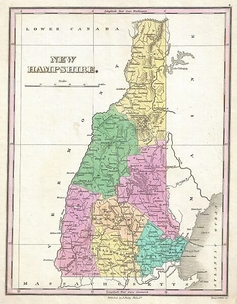
Framed Print : 1827, Finley Map of New Hampshire, Anthony Finley mapmaker of the United States in the 19th century
![]()

Framed Photos From Liszt Collection
1827, Finley Map of New Hampshire, Anthony Finley mapmaker of the United States in the 19th century
Liszt Collection of nineteenth-century engravings and images to browse and enjoy
Media ID 14007117
© Artokoloro Quint Lox Limited
1827 Antique Map Latitude Longitude Mappa Mundi Old Antique Plan Old Antique View Ols Antique Map Rare Old Maps Topo
12"x10" Modern Frame
Step back in time with our exquisite 1827 Finley Map of New Hampshire from the esteemed Liszt Collection. This rare and captivating framed print showcases the meticulous work of 19th-century American mapmaker, Anthony Finley. Meticulously preserved, the intricate details of this antique map reveal the historical landscape of New Hampshire as it appeared over 200 years ago. A perfect addition to any home or office, this framed print is not only a beautiful decorative piece but also a testament to the rich history of cartography. Bring the past into your present with the Media Storehouse's 1827 Finley Map of New Hampshire.
10x8 Print in an MDF Wooden Frame with 180 gsm Satin Finish Paper. Glazed using shatter proof thin plexi glass. Frame thickness is 1 inch and depth 0.75 inch. Fluted cardboard backing held with clips. Supplied ready to hang with sawtooth hanger and rubber bumpers. Spot clean with a damp cloth. Packaged foam wrapped in a card.
Contemporary Framed and Mounted Prints - Professionally Made and Ready to Hang
Estimated Image Size (if not cropped) is 25.4cm x 25.4cm (10" x 10")
Estimated Product Size is 25.4cm x 30.5cm (10" x 12")
These are individually made so all sizes are approximate
Artwork printed orientated as per the preview above, with landscape (horizontal) or portrait (vertical) orientation to match the source image.
EDITORS COMMENTS
This print showcases the 1827 Finley Map of New Hampshire, a remarkable creation by Anthony Finley, one of the most renowned mapmakers in 19th century United States. With its intricate details and exquisite craftsmanship, this vintage map offers a fascinating glimpse into the topography and geography of New Hampshire during that era. The illustration beautifully captures the diverse landscapes and geographical features of the region, allowing viewers to embark on a visual journey through time. The carefully plotted grid lines denote latitude and longitude coordinates, providing an accurate representation of the area's layout. This geometric precision highlights Finley's mastery in cartography. As an ancient relic from history, this decorative piece serves as both art and educational tool. Its aged appearance adds a touch of nostalgia while reminding us of our planet's rich past. The old antique view transports us back to a time when exploration and discovery were at their peak. Whether you are an avid traveler or simply fascinated by historical maps, this rare gem is sure to ignite your curiosity about New Hampshire's heritage. Displayed proudly on any wall or shelf, it invites you to delve into its intricacies and immerse yourself in the wonders of early American cartography.
MADE IN THE USA
Safe Shipping with 30 Day Money Back Guarantee
FREE PERSONALISATION*
We are proud to offer a range of customisation features including Personalised Captions, Color Filters and Picture Zoom Tools
SECURE PAYMENTS
We happily accept a wide range of payment options so you can pay for the things you need in the way that is most convenient for you
* Options may vary by product and licensing agreement. Zoomed Pictures can be adjusted in the Basket.


