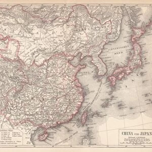
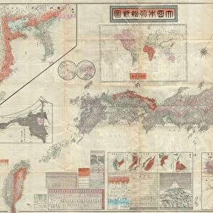
Framed Print : 1781, Japanese Temmei 1 Manuscript Map of Taiwan and the Ryukyu Dominion, topography


![]()
Framed Photos from Liszt Collection
1781, Japanese Temmei 1 Manuscript Map of Taiwan and the Ryukyu Dominion, topography
1781, Japanese Temmei 1 Manuscript Map of Taiwan and the Ryukyu Dominion
Liszt Collection of nineteenth-century engravings and images to browse and enjoy
Media ID 14006906
© Artokoloro Quint Lox Limited
1781 Antique Map Latitude Longitude Mappa Mundi Old Antique Plan Old Antique View Ols Antique Map Rare Old Maps Topo
18"x14" Modern Frame
Introducing the Media Storehouse Framed Print of the Rare 1781 Japanese Temmei 1 Manuscript Map of Taiwan and the Ryukyu Dominion from the Liszt Collection. This exquisite piece showcases intricate details of the topography of Taiwan and the Ryukyu Islands during the Edo period. The manuscript map's vibrant colors and intricate lines are brought to life in this high-quality print, making it a stunning addition to any home or office. Each print is carefully framed with a sleek and modern design, ensuring that the intricacies of the map are preserved and displayed beautifully. Travel back in time and explore the rich history of East Asia with this unique and captivating framed print.
16x12 Print in an MDF Wooden Frame with 180 gsm Satin Finish Paper. Glazed using shatter proof thin plexiglass. Frame thickness is 1 inch and depth 0.75 inch. Fluted cardboard backing held with clips. Supplied ready to hang with sawtooth hanger and rubber bumpers. Spot clean with a damp cloth. Packaged foam wrapped in a card.
Contemporary Framed and Mounted Prints - Professionally Made and Ready to Hang
Estimated Image Size (if not cropped) is 35.6cm x 40.6cm (14" x 16")
Estimated Product Size is 35.6cm x 45.7cm (14" x 18")
These are individually made so all sizes are approximate
Artwork printed orientated as per the preview above, with portrait (vertical) orientation to match the source image.
EDITORS COMMENTS
This print showcases a remarkable piece of history - the 1781 Japanese Temmei 1 Manuscript Map of Taiwan and the Ryukyu Dominion. With its intricate topography, this map offers a fascinating glimpse into the cartography and geography of that era. The detailed illustration takes us on a virtual journey through time, allowing us to explore the landforms, grid lines, latitude and longitude markings with precision. As we delve into this vintage treasure, we are transported back to an ancient world where paper maps were meticulously crafted by skilled artisans. The artistry behind this historical document is evident in its decorative elements and aged appearance, reminding us of the importance placed on navigation and exploration during those times. With its rare nature, this old antique map holds immense value for collectors and enthusiasts alike. It serves as a window into our past - an invaluable resource for researchers studying historical journeys or discovering new insights about regions long gone. The Liszt Collection has beautifully preserved this Japanese Temmei 1 Manuscript Map, ensuring that it continues to inspire awe and curiosity among those who appreciate both art and history. This print captures every detail of this magnificent relic so that it may be admired for generations to come.
MADE IN THE USA
Safe Shipping with 30 Day Money Back Guarantee
FREE PERSONALISATION*
We are proud to offer a range of customisation features including Personalised Captions, Color Filters and Picture Zoom Tools
SECURE PAYMENTS
We happily accept a wide range of payment options so you can pay for the things you need in the way that is most convenient for you
* Options may vary by product and licensing agreement. Zoomed Pictures can be adjusted in the Cart.