Framed Print > Europe > United Kingdom > England > London > Boroughs > City of London
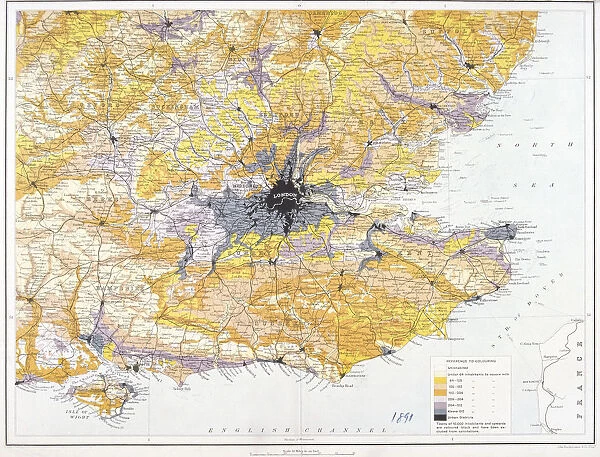
Framed Print : Map of London and south-east England, 1891. Artist: John Bartholomew
![]()

Framed Photos From Heritage Images
Map of London and south-east England, 1891. Artist: John Bartholomew
Map of London and south-east England, 1891. Map showing the population density of London and the surrounding counties
Heritage Images features heritage image collections
Media ID 15175636
© London Metropolitan Archives (City of London) / Heritage-Images
Bartholomew Cartography John Bartholomew Map Making Population Urban Sprawl Urbanisation Metaphor Population Density
12"x10" Modern Frame
Step back in time with our exquisite Framed Prints from Media Storehouse. This stunning piece showcases a historic Map of London and South-East England, dated 1891. Created by renowned cartographer John Bartholomew, this map offers a captivating glimpse into the past. Meticulously detailed, it highlights the population density of London and the surrounding counties, making it an intriguing addition to any room. Bring history into your home and transport yourself on a journey through time with our Framed Prints. Order yours today!
10x8 Print in an MDF Wooden Frame with 180 gsm Satin Finish Paper. Glazed using shatter proof thin plexi glass. Frame thickness is 1 inch and depth 0.75 inch. Fluted cardboard backing held with clips. Supplied ready to hang with sawtooth hanger and rubber bumpers. Spot clean with a damp cloth. Packaged foam wrapped in a card.
Contemporary Framed and Mounted Prints - Professionally Made and Ready to Hang
Estimated Image Size (if not cropped) is 25.4cm x 25.4cm (10" x 10")
Estimated Product Size is 30.5cm x 25.4cm (12" x 10")
These are individually made so all sizes are approximate
Artwork printed orientated as per the preview above, with landscape (horizontal) or portrait (vertical) orientation to match the source image.
FEATURES IN THESE COLLECTIONS
> Europe
> United Kingdom
> England
> London
> Boroughs
> City of London
> Europe
> United Kingdom
> England
> Maps
> Maps and Charts
> Related Images
EDITORS COMMENTS
This print showcases a remarkable piece of cartographic artistry by John Bartholomew, depicting the Map of London and south-east England in 1891. With its vibrant colors and intricate details, this lithograph offers a fascinating glimpse into the past, revealing not only the geographical layout but also the population density of London and its surrounding counties during that time. As we delve into this snapshot from history, we are transported back to an era characterized by rapid urbanization and sprawling development. The map serves as a metaphorical window into the challenges faced by a growing city grappling with expanding populations and changing landscapes. The Guildhall Library and Art Gallery has preserved this invaluable artifact, allowing us to appreciate both Bartholomew's skillful craftsmanship and his ability to capture the essence of 19th-century London. Every street corner, river bend, and county boundary is meticulously rendered on this map-making masterpiece. Through studying this visual representation of population density, one can discern how London evolved over time - witnessing firsthand how it transformed from quaint country villages to bustling metropolises. This print invites us to reflect upon our own place within history while marveling at the ingenuity required for such detailed cartography. Let this image transport you back in time as you explore every nook and cranny of London's streets through Bartholomew's artistic lens.
MADE IN THE USA
Safe Shipping with 30 Day Money Back Guarantee
FREE PERSONALISATION*
We are proud to offer a range of customisation features including Personalised Captions, Color Filters and Picture Zoom Tools
SECURE PAYMENTS
We happily accept a wide range of payment options so you can pay for the things you need in the way that is most convenient for you
* Options may vary by product and licensing agreement. Zoomed Pictures can be adjusted in the Basket.


