Framed Print > North America > Cuba > Cuba Heritage Sites > Old Havana and its Fortification System
Framed Print : Map of Havana, (1608), 1920s
, 1920s")

, 1920s")

![]()
Framed Photos From Heritage Images
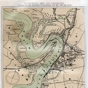
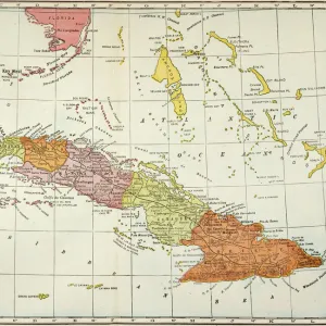
Map of Havana, (1608), 1920s
Map of Havana in 1604. We assume this map was made by Christopher Rodal. Havana had in 1608 a population of five hundred. Cigar card from the History of Cuba, Geografico Universal, Propaganda de los Cigarros Susini y La Corona, Tabacalera Cubana
Heritage Images features heritage image collections
Media ID 14958922
© The Print Collector
Access Cartography Christopher Cuba Cuban Island Map Making Shipping Industry Shipping Route Rodal
12"x10" Modern Frame
Step back in time with our exquisite Framed Print from Media Storehouse, featuring a captivating Map of Havana from the 1920s. This vintage map, sourced from Heritage Images, showcases the layout of Havana as it appeared in 1608, believed to be the work of Christopher Rodal. With a population of just five hundred, this rare and intriguing piece offers a glimpse into the rich history of Cuba. Add an air of sophistication and nostalgia to any room with this beautifully framed, historically significant print.
10x8 Print in an MDF Wooden Frame with 180 gsm Satin Finish Paper. Glazed using shatter proof thin plexi glass. Frame thickness is 1 inch and depth 0.75 inch. Fluted cardboard backing held with clips. Supplied ready to hang with sawtooth hanger and rubber bumpers. Spot clean with a damp cloth. Packaged foam wrapped in a card.
Contemporary Framed and Mounted Prints - Professionally Made and Ready to Hang
Estimated Image Size (if not cropped) is 25.4cm x 25.4cm (10" x 10")
Estimated Product Size is 30.5cm x 25.4cm (12" x 10")
These are individually made so all sizes are approximate
Artwork printed orientated as per the preview above, with landscape (horizontal) or portrait (vertical) orientation to match the source image.
FEATURES IN THESE COLLECTIONS
> Arts
> Minimalist artwork
> Monochrome artwork
> Fine art
> Arts
> Minimalist artwork
> Monochrome artwork
> Monochrome paintings
> Maps and Charts
> Related Images
> North America
> Cuba
> Cuba Heritage Sites
> Old Havana and its Fortification System
> North America
> Cuba
> Havana
> North America
> Cuba
> Maps
> North America
> Cuba
> Related Images
EDITORS COMMENTS
This print takes us back in time to the early 17th century, specifically Havana in 1608. The Map of Havana, believed to be crafted by Christopher Rodal, provides a fascinating glimpse into the city's past. At that time, Havana was a bustling hub with a modest population of five hundred inhabitants. The close-up view showcases the intricate details of this historical map. It highlights the bay area and its strategic location as an entrance point to Cuba, emphasizing its significance for trade and shipping industries during that era. This monochrome representation offers a unique perspective on how cartography was approached in the 1920s when this print was created. As we explore this piece further, it becomes evident that colonialism played a significant role in shaping Havana's development. The map serves as both an object of historical interest and a testament to Cuba's complex history. Preserved through time by The Print Collector29, this print is part of the History of Cuba collection produced for Geografico Universal - Propaganda de los Cigarros Susini y La Corona - Tabacalera Cubana. While we admire its beauty and appreciate its cultural value today, let us remember not to mention any commercial use associated with it. In conclusion, this remarkable image invites us to reflect on Havana's rich heritage while appreciating the artistry involved in map-making centuries ago.
MADE IN THE USA
Safe Shipping with 30 Day Money Back Guarantee
FREE PERSONALISATION*
We are proud to offer a range of customisation features including Personalised Captions, Color Filters and Picture Zoom Tools
SECURE PAYMENTS
We happily accept a wide range of payment options so you can pay for the things you need in the way that is most convenient for you
* Options may vary by product and licensing agreement. Zoomed Pictures can be adjusted in the Basket.