Framed Print > Maps and Charts > World
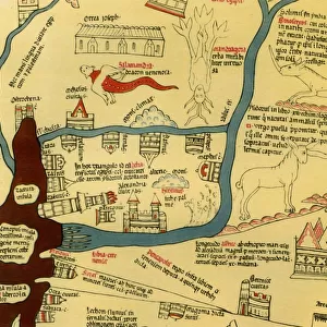
Framed Print : The Ebstorf Map, c. 1300. Artist: Anonymous master


![]()
Framed Photos From Heritage Images
The Ebstorf Map, c. 1300. Artist: Anonymous master
The Ebstorf Map, c. 1300. Found in the collection of Ebstorf Abbey, Lueneburg
Heritage Images features heritage image collections
Media ID 15023494
© Fine Art Images
Anonymous Master Watercolour On Parchment World Map Mappa Mundi
12"x10" Modern Frame
Introducing the Media Storehouse Framed Print of 'The Ebstorf Map, c. 1300' from Heritage Images. This awe-inspiring work of medieval cartography, created by an anonymous master around 1300, is a true testament to the artistic and geographical knowledge of the time. The Ebstorf Map, housed in the collection of Ebstorf Abbey in Lueneburg, Germany, is a rare and intricately detailed representation of the known world during the Middle Ages. Our Framed Print brings this historic masterpiece into your home or office, offering a captivating glimpse into the past. Each print is carefully crafted with museum-quality materials, ensuring lasting beauty and durability. Add this unique and educational piece to your collection today and enjoy the rich history it brings to your space.
10x8 Print in an MDF Wooden Frame with 180 gsm Satin Finish Paper. Glazed using shatter proof thin plexi glass. Frame thickness is 1 inch and depth 0.75 inch. Fluted cardboard backing held with clips. Supplied ready to hang with sawtooth hanger and rubber bumpers. Spot clean with a damp cloth. Packaged foam wrapped in a card.
Contemporary Framed and Mounted Prints - Professionally Made and Ready to Hang
Estimated Image Size (if not cropped) is 25.4cm x 25.4cm (10" x 10")
Estimated Product Size is 30.5cm x 25.4cm (12" x 10")
These are individually made so all sizes are approximate
Artwork printed orientated as per the preview above, with landscape (horizontal) or portrait (vertical) orientation to match the source image.
FEATURES IN THESE COLLECTIONS
> Maps and Charts
> Related Images
> Maps and Charts
> World
The Ebstorf Map, c. 1300 - A Glimpse into Medieval Cartography
EDITORS COMMENTS
. This print showcases the remarkable "Ebstorf Map" a masterpiece of medieval cartography created by an anonymous master in the year 1300. Found within the esteemed collection of Ebstorf Abbey in Lueneburg, Germany, this world map offers a fascinating insight into how our ancestors perceived and represented their known world. Crafted with meticulous detail on watercolour-painted parchment, this mappa mundi is a testament to both artistic skill and geographical knowledge of its time. Measuring approximately three meters in diameter, it presents Europe at its center while depicting other continents such as Africa and Asia surrounding it. The Ebstorf Map not only serves as a navigational tool but also conveys religious symbolism prevalent during the Middle Ages. Biblical scenes are intricately woven throughout the map's borders, illustrating stories from both Old and New Testaments. These illustrations remind viewers that faith played an integral role in shaping people's understanding of geography during this era. Preserved through centuries of history, this fine art piece continues to captivate scholars and enthusiasts alike with its unique blend of artistic beauty and historical significance. It stands as a testament to human curiosity about our place in the world and serves as a reminder that maps have always been more than mere representations; they reflect cultural beliefs, aspirations, and perceptions. As we gaze upon this exquisite print capturing The Ebstorf Map's intricate details today
MADE IN THE USA
Safe Shipping with 30 Day Money Back Guarantee
FREE PERSONALISATION*
We are proud to offer a range of customisation features including Personalised Captions, Color Filters and Picture Zoom Tools
SECURE PAYMENTS
We happily accept a wide range of payment options so you can pay for the things you need in the way that is most convenient for you
* Options may vary by product and licensing agreement. Zoomed Pictures can be adjusted in the Basket.