Framed Print > Europe > United Kingdom > England > Related Images
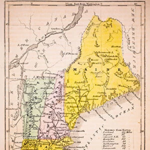
Framed Print : MAP OF NEW ENGLAND, 1732. Henry Popples map of New England, published in London


![]()
Framed Photos From Granger
MAP OF NEW ENGLAND, 1732. Henry Popples map of New England, published in London
MAP OF NEW ENGLAND, 1732.
Henry Popples map of New England, published in London, England, in 1732
Granger holds millions of images spanning more than 25,000 years of world history, from before the Stone Age to the dawn of the Space Age
Media ID 12321056
1732 Atlantic Ocean Coast Colonial Henri New England Seashore United States Popple
18"x14" Modern Frame
Step back in time with our exquisite Framed Prints from the Media Storehouse collection. This captivating piece showcases the intricately detailed 1732 Henry Popples Map of New England, published in London. Beautifully preserved, this antique map transports you to a bygone era, offering a unique glimpse into the historical geography of New England over three centuries ago. Add this stunning work of art to your home or office and bring a touch of history into your space.
16x12 Print in an MDF Wooden Frame with 180 gsm Satin Finish Paper. Glazed using shatter proof thin plexiglass. Frame thickness is 1 inch and depth 0.75 inch. Fluted cardboard backing held with clips. Supplied ready to hang with sawtooth hanger and rubber bumpers. Spot clean with a damp cloth. Packaged foam wrapped in a card.
Contemporary Framed and Mounted Prints - Professionally Made and Ready to Hang
Estimated Image Size (if not cropped) is 35.6cm x 40.6cm (14" x 16")
Estimated Product Size is 35.6cm x 45.7cm (14" x 18")
These are individually made so all sizes are approximate
Artwork printed orientated as per the preview above, with portrait (vertical) orientation to match the source image.
FEATURES IN THESE COLLECTIONS
> Europe
> United Kingdom
> England
> London
> Related Images
> Europe
> United Kingdom
> England
> Related Images
> North America
> Related Images
EDITORS COMMENTS
This print showcases the historic "Map of New England, 1732" by Henry Popple. Published in London, England during the early colonial era, this map offers a fascinating glimpse into the North American continent's past. With intricate details and precision, Popple's map depicts the vast expanse of New England, stretching from the Atlantic Ocean to its picturesque coastlines. The rivers meander across the landscape like lifelines connecting communities and providing vital transportation routes. As we delve into this piece of cartographic artistry, it becomes evident that Popple was not only an exceptional geographer but also a keen observer of nature. The seashore is beautifully rendered with delicate strokes, capturing both its rugged beauty and untamed allure. This historical artifact serves as a testament to America's rich heritage and its colonial roots. It transports us back in time to an era when exploration and settlement were shaping what would eventually become the United States. Whether you are an avid history enthusiast or simply appreciate fine artistry, this print invites you to immerse yourself in a world where discovery meets artistic brilliance. Hang it proudly on your wall and let it be a conversation starter for all who admire its beauty – reminding us of our collective journey through time.
MADE IN THE USA
Safe Shipping with 30 Day Money Back Guarantee
FREE PERSONALISATION*
We are proud to offer a range of customisation features including Personalised Captions, Color Filters and Picture Zoom Tools
SECURE PAYMENTS
We happily accept a wide range of payment options so you can pay for the things you need in the way that is most convenient for you
* Options may vary by product and licensing agreement. Zoomed Pictures can be adjusted in the Basket.