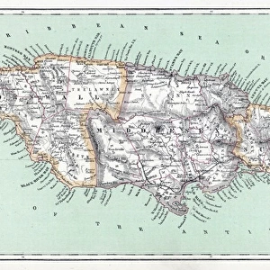
Framed Print > Arts > Landscape paintings > Waterfall and river artworks > River artworks
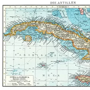
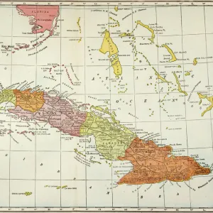
Framed Print : MAP: CUBA, 1900. Map of Cuba printed in the United States, c1900


![]()
Framed Photos from Granger
MAP: CUBA, 1900. Map of Cuba printed in the United States, c1900
MAP: CUBA, 1900.
Map of Cuba printed in the United States, c1900
Granger holds millions of images spanning more than 25,000 years of world history, from before the Stone Age to the dawn of the Space Age
Media ID 6617535
1900 Cuba Cuban Island Latin America
12"x10" Modern Frame
Introducing the latest addition to our Media Storehouse Framed Prints collection: "MAP: CUBA, 1900." This captivating vintage map, originally printed in the United States around 1900, is now available as a beautifully framed print from Granger Art on Demand. The intricate details of Cuba's geography, including its major cities, bays, and islands, are brought to life in this antique map. Hang this unique piece in your home or office to add a touch of history and character to any space. Experience the charm of the past with our high-quality framed print of "MAP: CUBA, 1900." by The Granger Collection, New York.
10x8 Print in an MDF Wooden Frame with 180 gsm Satin Finish Paper. Glazed using shatter proof thin plexi glass. Frame thickness is 1 inch and depth 0.75 inch. Fluted cardboard backing held with clips. Supplied ready to hang with sawtooth hanger and rubber bumpers. Spot clean with a damp cloth. Packaged foam wrapped in a card.
Contemporary Framed and Mounted Prints - Professionally Made and Ready to Hang
Estimated Image Size (if not cropped) is 25.4cm x 25.4cm (10" x 10")
Estimated Product Size is 30.5cm x 25.4cm (12" x 10")
These are individually made so all sizes are approximate
Artwork printed orientated as per the preview above, with landscape (horizontal) or portrait (vertical) orientation to match the source image.
FEATURES IN THESE COLLECTIONS
> Arts
> Landscape paintings
> Waterfall and river artworks
> River artworks
> Maps and Charts
> Early Maps
> Maps and Charts
> Related Images
> North America
> Cuba
> Maps
> North America
> Cuba
> Related Images
> Granger Art on Demand
> Maps
EDITORS COMMENTS
This print showcases a remarkable piece of history - a map of Cuba from the year 1900. Created and printed in the United States, this meticulously detailed map offers a glimpse into the early days of this enchanting island nation. The intricate cartography beautifully captures the topography, rivers, and various regions that make up Cuba's diverse landscape. As we delve into this snapshot from the past, it is impossible not to be transported back to an era when Cuba was on the cusp of significant change. This map serves as a testament to both its historical significance and cultural importance within Latin America. The Granger Collection has expertly preserved this valuable artifact, allowing us to appreciate its beauty and educational value today. Through their careful preservation efforts, they have ensured that future generations can continue to explore and learn about Cuban history through visual representations like this one. Whether you are an avid historian or simply captivated by maps, this print is sure to spark curiosity and ignite your imagination. It invites us all to embark on a journey through time as we trace our fingers along each contour line and immerse ourselves in the rich heritage of Cuba.
MADE IN THE USA
Safe Shipping with 30 Day Money Back Guarantee
FREE PERSONALISATION*
We are proud to offer a range of customisation features including Personalised Captions, Color Filters and Picture Zoom Tools
SECURE PAYMENTS
We happily accept a wide range of payment options so you can pay for the things you need in the way that is most convenient for you
* Options may vary by product and licensing agreement. Zoomed Pictures can be adjusted in the Cart.