Framed Print > Maps and Charts > Americas
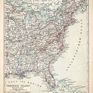
Framed Print : Map of the Eastern United States of America, 19th Century


![]()
Framed Photos From Fine Art Storehouse
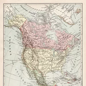
Map of the Eastern United States of America, 19th Century
Vintage engraving of a Map of the Eastern United States of America, late 19th Century
Unleash your creativity and transform your space into a visual masterpiece!
duncan1890
Media ID 19684331
© of Duncan P Walker
12"x10" Modern Frame
Step back in time with our vintage engraving of a Map of the Eastern United States of America, a stunning addition to your decor from the Fine Art Storehouse at Media Storehouse. This beautiful framed print, created by duncan1890, showcases intricate detail and authenticity of a bygone era. The late 19th century map captures the historical essence of the Eastern United States, making it a unique and captivating conversation piece for your home or office. Bring history to life and transport yourself to another era with this exquisite framed print.
10x8 Print in an MDF Wooden Frame with 180 gsm Satin Finish Paper. Glazed using shatter proof thin plexi glass. Frame thickness is 1 inch and depth 0.75 inch. Fluted cardboard backing held with clips. Supplied ready to hang with sawtooth hanger and rubber bumpers. Spot clean with a damp cloth. Packaged foam wrapped in a card.
Contemporary Framed and Mounted Prints - Professionally Made and Ready to Hang
Estimated Image Size (if not cropped) is 25.4cm x 25.4cm (10" x 10")
Estimated Product Size is 25.4cm x 30.5cm (10" x 12")
These are individually made so all sizes are approximate
Artwork printed orientated as per the preview above, with landscape (horizontal) or portrait (vertical) orientation to match the source image.
FEATURES IN THESE COLLECTIONS
> Maps and Charts
> Related Images
> North America
> United States of America
> Related Images
EDITORS COMMENTS
This print showcases a vintage engraving of a Map of the Eastern United States of America, dating back to the late 19th century. With intricate details and exquisite craftsmanship, this piece from Duncan1890 takes us on a journey through time, offering a glimpse into the past. As we gaze upon this map, we are transported to an era where exploration and discovery were at their peak. The carefully etched lines trace the borders of each state with precision, while rivers and mountain ranges come alive with delicate strokes. It is as if history unfolds before our eyes. The faded hues add a touch of nostalgia to this artwork, reminding us that it has witnessed countless stories unfold over generations. From bustling cities to vast stretches of untouched wilderness, every inch holds tales waiting to be discovered. This map not only serves as a geographical guide but also offers insight into the cultural and historical fabric that shaped the Eastern United States during that period. It invites us to ponder how these lands have evolved since then and appreciate the rich heritage they hold. Whether you are an avid historian or simply captivated by art's ability to transport us across time and space, this print is sure to spark curiosity and ignite your imagination. Let it adorn your walls as both a testament to human ingenuity in cartography and an invitation for exploration within yourself.
MADE IN THE USA
Safe Shipping with 30 Day Money Back Guarantee
FREE PERSONALISATION*
We are proud to offer a range of customisation features including Personalised Captions, Color Filters and Picture Zoom Tools
SECURE PAYMENTS
We happily accept a wide range of payment options so you can pay for the things you need in the way that is most convenient for you
* Options may vary by product and licensing agreement. Zoomed Pictures can be adjusted in the Basket.